background image

21

GPSmap 76C

GPS Navigation

Find Menu

Using Find 

Using the Find Menu

The Find Feature provides you with a method for searching for Cities, 

Exits and Marine Tide Stations which are included in the GPSmap 76C 
basemaps. If you have downloaded Garmin MapSource mapping data 
that contains additional map detail, you can search for and fi nd Points of 
Interest, Addresses and Intersections. If you download BlueChart

®

 data*, 

you can fi nd detailed Marine items such as Wrecks and Obstructions, 
NAVAIDS, and Anchorages. If this additional data is not loaded, these 
options are not available. Waypoints and Geocache Points are items you 
can create and add to the Find Menu.

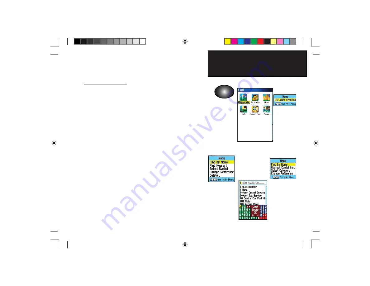
Searching for a map item is simplifi ed by separating the map database 

into groups which are shown as icons on the Find Menu Page.

• When you access a Find group list, by default it will contain only 

those items near your current location or the Panning Arrow (if active). 

• To save effort in searching again for an item already found, you can 

use the “Recent Finds” group which contains a list of 50 last found 
items of all categories. 

The options menu for each map item group offers its own unique 

search options such as “Find By Name”, “Find Nearest”, “Select Symbol” 
(for Waypoints),  “Change Reference” ( by moving the map Panning Arrow 
to a new location), “Nearest Containing” (a key word you enter), “Select 
Category” (for those groups such as Food and Drink, Lodging, etc.). Using 
these options can effectively shorten your search. 

* Refer to the Garmin website: http://www.garmin.com//cartography/mapSource/ 

         bluechartCD.jsp

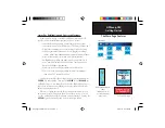
FIND

Press the 

FIND key to 

display the 
Find Menu

Find By Name

Option

Options Menu 

for groups with 
Sub-Categories

Options Menu 

for Waypoints

Auto Ordering 

Option places 

the last selected 

category at the 

top of the order.

GPSmap 76C Owner's Guide copy.indd   21

3/25/2004, 11:29:48 AM

Summary of Contents for GPSMAP 76C

Page 1: ...color map navigator owner s manual GPSMAP GPSmap 76C Front Cover indd 1 3 25 2004 1 38 38 PM...

Page 2: ...and to print one copy of this manual or of any revision hereto provided that such electronic or printed copy of this manual must contain the complete text of this copyright notice and provided further...

Page 3: ...d an overview of the GPSmap 76C functional features Getting Started takes you through installing batteries using the unit control buttons making interface connections from the GPSmap 76C to your PC an...

Page 4: ...y of Garmin and is protected under the United States of America copyright laws and international copyright treaties You further acknowledge that the structure organization and code of the Software are...

Page 5: ...that interference will not occur in a particular installation If this equipment does cause harmful interference to radio or television reception which can be determined by turning the equipment off a...

Page 6: ...SPONSIBILITY TO USE THIS PRODUCT PRUDENTLY THIS PRODUCT IS INTENDED TO BE USED ONLY AS A NAVIGATIONAL AID AND MUST NOT BE USED FOR ANY PURPOSE REQUIRING PRECISE MEASUREMENT OF DIRECTION DISTANCE LOCAT...

Page 7: ...s operated by the United States government which is solely responsible for its accuracy and maintenance The system is subject to changes which could affect the accuracy and performance of all GPS equi...

Page 8: ...r the consequences thereof WARNING When used in vehicles it is the sole responsibility of the driver of the vehicle to operate the vehicle in a safe manner maintain full surveillance of all driving co...

Page 9: ...Smap 76C 5 The Main Page Sequence 6 The Main Page Features 7 Section 3 GPS Navigation 8 54 The Map Page 8 The Compass Page 14 The Trip Computer Page 16 Using Waypoints 17 Using Find 21 The Main Menu 3...

Page 10: ...Non Enhanced Game 67 Section 5 Appendices 68 84 Accessories 68 Specifcations 70 Data Field De nitions 72 Connecting the GPSmap 76C to a Computer 76 Downloading MapSource Map Data 77 UTC Offset Chart 7...

Page 11: ...t backlighting intensity and timeout see page 48 To disable WAAS see page 47 To mute the beep tones see page 50 Getting Started Installing the Batteries The GPSmap 76C operates on two AA batteries not...

Page 12: ...exit a page ROCKER Key Move Up Down or Right Left to move through lists highlight fields on screen buttons icons enter data or move the map panning arrow PAGE Key Press to cycle through the main page...

Page 13: ...Cover USB Connector Port under weather cover Provides interface to a PC for faster data transfer Unit Features GPS Quad Helix Antenna on front of unit Provides quick satellite acquisition External Po...

Page 14: ...t initialization select New Location from the options menu then you can use the Map Page to determine your general location so the GPSmap 76C can search for just those satel lites above your position...

Page 15: ...you map details your current loca tion marks your route to a destination with a route line and leaves a trail track log of where you ve been The Compass Page indicates direction to go and direction of...

Page 16: ...ease the PAGE key repeatedly to cycle through the pages 2 With a Page displayed press the MENU key to display the list of options for that page Satellite Page Trip Computer Page Map Page Compass Page...

Page 17: ...When On it uses a signi cant amount of battery power This icon displays when the backlight is functioning Alarm Clock this icon displays whenever the Alarm is set USB cable connection displays when t...

Page 18: ...nrise and sunset The map also displays geographic details such as rivers lakes highways towns and Tide Prediction Stations contained in the basemaps included with the unit The maps to the left show a...

Page 19: ...n Accuracy Circle surround ing the Position Icon The GPSmap 76C uses both map resolution and GPS accuracy in de ning your location to a point within the circle The smaller the circle the more accurate...

Page 20: ...feature you want to use to customize the Map Page and press the ENTER key Some of these options contain sub menus that allow you to further control of how the option is used The pages that follow disc...

Page 21: ...ce and press ENTER To change Data Fields 1 Display the data elds a Change Data Fields option appears on the options menu when you press the MENU key 2 Select this option and pressing the ENTER key to...

Page 22: ...d whether or not you are navigating If you select Show When Navigating a guidance message will be displayed until you select Stop Navigation from the Options Menu Guidance Text shows you useful inform...

Page 23: ...nt Press QUIT to cancel Turning Declutter On Off This Map Page option allows you to remove map item titles and icons that clutter the view of roadways especially when the map is zoomed to a scale that...

Page 24: ...Bearing Pointer indicates the direction bearing to your destination relative to your current heading direction The compass dial and bearing pointer work independently to show your direction of movemen...

Page 25: ...tinue in that direction If you are using the Course Pointer option instead and you drift away from the line of travel to your destination the Course Deviation Indicator CDI provides graphic indication...

Page 26: ...ta at a glance you can use the Big Numbers option which shows fewer elds with larger displays Before each trip be certain to reset the trip information by highlight ing Reset from the options menu and...

Page 27: ...ER key and ENTER key to select a name for the waypoint If you choose a name that has already been used a Waypoint Already Exits message will appear Press ENTER to acknowledge and choose a new name 3 T...

Page 28: ...this point Do you want to create a user waypoint here Select Yes and press ENTER to display a new waypoint page Another method for creating a waypoint is the Man Overboard MOB feature Typically an app...

Page 29: ...ited to change the map symbol name location coordinates elevation or to delete it Refer to page 21 for details on using the Find Feature To edit a Waypoint 1 Use the Find Feature to display the desire...

Page 30: ...aypoint Projecting a waypoint from any map item another waypoint etc allows you to establish a new waypoint on a bearing and distance pro jected from that map item To project a waypoint 1 Select an it...

Page 31: ...p list by default it will contain only those items near your current location or the Panning Arrow if active To save effort in searching again for an item already found you can use the Recent Finds gr...

Page 32: ...and press ENTER to go a list where you can select the item 5 Next the Information Page for that location will display Searching for a location using Recent Finds The Recent Finds Page saves all of yo...

Page 33: ...t the bottom of the page are three on screen buttons these buttons will appear differently depending on whether you are selecting a Find item to navigate to or adding a Find item to a route list as a...

Page 34: ...ly it samples a waypoint location over time and averages the result for a more accurate position reference Refer to page 19 for detailed information on Location Averaging Project Waypoint Create a new...

Page 35: ...xisting route See Using Routes page 45 on for details View Sun and Moon View the Sun and Moon tables for this item location Refer to page 62 for detailed information about the Sun and Moon Tables View...

Page 36: ...of search options Find By Name allows you to enter the name of the waypoint in a search eld Find Nearest allows you to list only those waypoints near your current location Select Symbol allows you to...

Page 37: ...NTER to display the Geocache List You can display either found geocaches or those that have not been found 3 Use the ROCKER key to highlight the desired geocache on the list and press ENTER to display...

Page 38: ...ities near est a new location on the map 3 If using nd By Name begin spelling the name of the city by using the keyboard When you have entered enough characters to de ne the name a match list displays...

Page 39: ...to highlight the desired exit 6 Press ENTER to display the Information Page for that exit This page contains the exit description with a list of available ser vices near that exit along with the dista...

Page 40: ...n then press ENTER 4 A list of tide stations nearest to you displays If a None Found message displays then you are not currently located near a coast line Press the MENU key to display the Tide Statio...

Page 41: ...list and press ENTER to display the information page for that item At the bottom of the Information Page are on screen buttons for Go To Map and Save To find Marine Services 1 Follow the same procedur...

Page 42: ...ion and make your selection Use the on screen keypad to enter the rst few letters of the city name until the desired city moves to the top of the list Highlight OK on the key pad and press ENTER With...

Page 43: ...f cities for the region and make your selection Use the on screen keypad to enter the rst few let ters of the city name until the desired city moves to the top of the list Highlight OK on the key pad...

Page 44: ...the MENU key to choose from search options or choose Select Category to narrow your search 4 Highlight the desired item from the list and then press ENTER to display the Information Page for that item...

Page 45: ...t you wish to navigate to in a speci c order and save for later use Highway A useful graphic perspective for navigating a route Setup Controls the settings for many of the unit operating system featur...

Page 46: ...display the Tracks Page The page contains On and Off buttons to activate or cancel the Track Log and a Track Log meter which displays the percentage of track log space used 3 Beneath the Track Log eld...

Page 47: ...Entire Track If you select Yes a Saving Track message appears followed by the Saved Track Page The new saved track will be a representation of the entire track log from beginning to end 2 If you selec...

Page 48: ...Map Page 2 A map showing the entire track appears with Begin and End markers Any User Waypoints added to the Track will be displayed as well To calculate the area of a Track 1 With the Track Log Page...

Page 49: ...ved Tracks Page for the Track displayed press the MENU key to display the Pro le option 2 Then press ENTER to display the Track Pro le The beginning of the track is marked by a ag and you can scroll a...

Page 50: ...ime you use TracBack 4 When the TracBack Navigation Page displays directions to the rst turn on the track display at the top of the page Move in the direction of the rst turn When you reach the rst tu...

Page 51: ...ghlight the New button and press ENTER to display the route Setup Page 3 With an empty row dashed in the route list highlighted press ENTER to display the Find Menu 4 Use the Find Menu to select a rou...

Page 52: ...ROCKER key Up or Down arrows while the route is active These two navigation methods change when you select the Follow Roads option from the Routing Setup Page Both Go To navigation and point to point...

Page 53: ...an Active Route 1 From the Routes Page highlight the route from the Routes list 2 Press ENTER to display the Route Page for the route 3 Highlight the Navigate button and press ENTER to begin navigatio...

Page 54: ...press ENTER A prompt will display asking Do you really want to delete all routes Select Yes and press ENTER To select the Off Road transition for a route 1 Access the Saved Routes Page from the Main M...

Page 55: ...7 for details 1 Select Pro le and press ENTER to display the route pro le To copy the route 1 Highlight the Copy Route option and press ENTER The copied route displays on the Routes Page and is named...

Page 56: ...own the middle of the graphic As you move toward each point on your route the graphic will show the direction you should move to stay on course to the point Five scale settings allow you to Zoom In or...

Page 57: ...are explained in the sections that follow System Setup The System Setup Page allows you to select from four modes of GPS operation enable disable WAAS see page 80 designate battery type cur rently be...

Page 58: ...t and output of standard NMEA 0183 version 3 01 data Text Out Allows ASCII text output of location and velocity informa tion No input Interface Setup Page Data Format Options Display Setup Display Set...

Page 59: ...s the Interface Setup Page as explained at the beginning of this section 2 Highlight the desired setting and press ENTER 3 When you select Text Out and or RTCM In additional elds will appear Use the R...

Page 60: ...d to the sequence it will no longer appear in the Main Menu To move insert or remove a page 1 Access the Page Sequence Setup Page 2 To move a page in the order highlight the page and press ENTER Selec...

Page 61: ...ure The map display for your GPSmap 76C is user con gurable A factory set of default settings currently control the Map Page display and may be satisfactory for your current requirements The Map Setup...

Page 62: ...isplayed You can lock the Position Arrow to display on the nearest road compensating for variances in map position accuracy Map Setup Tracks Settings The Tracks feature settings which records a log of...

Page 63: ...of downloaded detailed maps such as topographic marine charts and MapSource maps with auto routing capability Use the ROCKER key to highlight the desired map and then the ENTER key to show it on the m...

Page 64: ...me a route is being calculated Otherwise the chosen method will always be used for navigation 3 If you chose Follow Road then the Follow Road Method eld will offer a similar choice of Prompted Faster...

Page 65: ...certain you are not in viola tion of ordinances or laws governing use of these properties Marine Setup The Marine Setup Page allows you to set values for limits which acti vate alarms for features sp...

Page 66: ...r loca tion Refer the UTC Chart on page 78 4 Daylight Savings Time offers choices of Yes No and Auto Units Setup The Units Setup Page allows you to select the units of measurement for your GPSmap 76C...

Page 67: ...Reference eld press ENTER and select from True North Magnetic North Grid North or User Grid North Welcome Page Setup The Welcome Page Setup Page allows you to insert a message such as ownership inform...

Page 68: ...tion Page for that item 4 With the Use button at the bottom of the page highlighted press ENTER to place the point in the list on the Proximity Waypoints Page 5 Next use the ROCKER key to highlight t...

Page 69: ...type of point you want to place on the Day Page See page 21 for details on using the Find Feature With the Information Page for that point displayed highlight the Use button and press ENTER to place...

Page 70: ...isplay the On Off switch 4 Highlight the Alarm Beep eld and select the type of alarm tone desired When you turn the alarm On an Alarm Set message appears and allows you to turn the unit Off When the S...

Page 71: ...opwatch 1 With the stopwatch stopped use the ROCKER key to highlight the Reset eld and then press ENTER To time lap by distance 1 Use the ROCKER key to highlight the Options Menu and then press ENTER...

Page 72: ...at a given time date The button to the left animates the display of the sun and moon The center button animates more rapidly showing the phases of the moon The right button stops animation To display...

Page 73: ...ghlight the Location eld and press ENTER to display the New Location options menu Choose Use Map to select a point on the map using the Panning Arrow Then press ENTER to display the table for that loc...

Page 74: ...ch square has which symbol then clear the board by matching all of the two symbol sets together Travel to each square highlight Open at the bottom of the screen and press ENTER to view the symbol Pres...

Page 75: ...f 2 Turn the cheat mode Off by pressing the ENTER key Geko Smak Geko Smak is a GPS based game that features you as the player piece In measured rhythm Gekos will appear on the screen Before the Geko d...

Page 76: ...ing hit Before you begin to play make certain to make your game settings Orient Map Northwards rotates your ship in the center of the map The map is stationary and north is always up Orient Map Ship U...

Page 77: ...ames Menu and press ENTER to display the game prompt window 2 Read the prompt and then press ENTER to display the Dif culty Options window Make your choice and press ENTER to display Visibility Option...

Page 78: ...des protection during transport of the unit Not shown Auto Navigation Kit Allows installation on a vehicle dash and includes Garmin MapSource City Select North America v5 CD ROM CD Not shown Marine Mo...

Page 79: ...Cable Connector Serial Port under weather cover Carry Lanyard Installation External Antenna Connector MCX under weather cover USB Connector under weather cover Marine Mount Kit Bicycle Handlebar Moun...

Page 80: ...quad helix with remote antenna capability Keypad Nine multifunction backlit keys Operating Range 5 to 158 o F 15 to 70 o C 1 PERFORMANCE Receiver WAAS enabled 12 parallel channel Acquisition Time War...

Page 81: ...l use 4 Speci cations subject to change without notice 1 The temperature rating to the GPSmap 76C may exceed the usable range of some batter ies Some batteries can rupture at high temperatures 2 Subje...

Page 82: ...on point Depth The depth of water from sonar NMEA input Distance Next The distance to the next point on a route Distance Destination The entire distance from beginning to end of a route ETA Next The e...

Page 83: ...her than lat lon Odometer The total distance you have traveled for all trips Off Course The distance off your direct course line right or left Pointer The arrow that indicates the direction to travel...

Page 84: ...mat in local time or universal UTC time To Course Your direction of travel to get back on course Trip Odometer The running total of distance traveled since the Trip Computer was reset Trip Time Moving...

Page 85: ...of accent to a predetermined height Water Speed The data acquired from measurement devices interfaced to the GPSmap 76C is used to calculate your current speed over water Water Temperature The tempera...

Page 86: ...76C and insert the smaller connector on the USB cable provided with the unit into the matching port 2 Connect the remaining cable end to your PC USB port 3 Set your GPSmap 76C interface setting to GA...

Page 87: ...the same loca tion at the same time one will draw over the other When you leave a MetroGuide area for example and enter the area of a topographic map the display will change to contour lines The same...

Page 88: ...e Mark Waypoint Location field It should fall within the sets of values on the chart Press the QUIT key to avoid marking a waypoint Longitudinal Zone Offset W180 0 to W172 5 12 00 W172 5 to W157 5 11...

Page 89: ...ference the map datum in the GPS unit should be set to the same datum as the map or chart to insure the most accurate navigation What is a Position Format and which should I use Your current location...

Page 90: ...ore information go to http gps faa gov Programs WAAS waas htm What is Differential GPS DGPS The U S and Canadian governments among others have set up Differential GPS DGPS stations to transmit correct...

Page 91: ...L GPGSA GPGSV GPRMB GPRMC GPRTE GPVTG GPWPL GPBOD Garmin Proprietary Sentences PGRME estimated error PGRMM datum string PGRMZ altitude PSLIB beacon receiver control DGPS Differential GPS corrections a...

Page 92: ...ache 29 Find Intersections 35 Find Points of Interest 36 Find Waypoints 38 G Games 64 67 Geocache Setup 55 Global Positioning System GPS 4 Go To 5 23 H Heading Setup 57 Highway Page 46 Hunt and Fish T...

Page 93: ...1 45 W WAAS Enable Disable 47 Warnings iv vi Waypoints 17 20 Deleting 19 Editing 19 List 26 Marking 17 Moving 20 Naming 17 Projecting 20 Proximity 58 Symbols 17 Welcome Page Setup 57 Wiring Diagram In...

Page 94: ...BLE FOR ANY INCIDENTAL SPECIAL INDIRECT OR CONSEQUENTIAL DAMAGES WHETHER RESULT ING FROM THE USE MISUSE OR INABILITY TO USE THIS PRODUCT OR FROM DEFECTS IN THE PRODUCT Some states do not allow the exc...

Page 95: ...GPSmap 76C Front Cover indd 3 3 25 2004 1 40 01 PM...

Page 96: ...Abbey Park Industrial Estate Romsey SO51 9DL U K Garmin Corporation No 68 Jangshu 2nd Road Shijr Taipei County Taiwan www garmin com Part Number 190 00340 00 Rev A For the latest free software update...

Reviews: