
Specifications are preliminary and subject to change
without notice.
* Subject to accuracy degradation to 100m
2DRMS under the U.S. Department of Defense
imposed Selective Availability Program.
**Depth capacity is dependent on water salinity,
bottom type, and other water conditions.
Power
Source:
8-35v DC
Usage:
4 watts max. at 13.8v DC
Physical
Size:
6.3" W x 6.2" H x 2.6" D
Weight:
1.4 lbs. (.64 kg)
Display:
5.0" diagonal (12.7 cm) 16-color TFT
display with backlighting (234 x 320 pixels)
Case:
Fully gasketed, high impact plastic alloy,
waterproof to IEC 60529 IPX7 standards
Temp. range:
5ºF to 158ºF (-15ºC to 70ºC)
Accessories
Standard:
GPSMAP 192C, external GPS antenna, unit,
power/data cable, swivel/ball mount, GA
29 antenna, unit cover, owner’s manual
and quick reference guide
GPSMAP 192C, internal GPS antenna,
unit, power/data cable, swivel/ball
mount, quad helix antenna, unit cover,
owner’s manual and quick
reference guide
Optional:
preprogrammed data cards with
BlueChart
™
marine cartography
AC/PC adapter
12-volt adapter cable
bail mount antenna bracket
USB data card programmer
MapSource
®
CDs:
BlueChart
®
Minnesota LakeMaster
®
U.S. Recreational Lakes with
Fishing Hot Spots
®
REV0405
M01-10196-00
Navigation features
Waypoints/icons:
3000 with name, symbol and comments;
support for proximity waypoints
Routes:
50 reversible routes with up to 254 points
each, plus MOB and TracBack
®
modes
Tracks:
2500 point automatic track log, 15 saved
tracks; 500 points per saved track, lets
you retrace your path in both directions
Alarms:
Anchor drag, arrival, off course,
proximity waypoint, clock and low battery
Tables:
Built-in celestial tables with sun and
moon rise, set and location. Tide tables
for the U.S.
Map datums:
More than 100, plus user datum
Position format:
Lat/Lon, UTM/UPS, Loran TDs and other
grids, including user grid
Languages:
10
GPS performance
Receiver:
WAAS enabled, 12 parallel channel GPS
receiver continuously tracks and uses up
to 12 satellites to compute and update
your position
Acquisition times:
Warm:
Approximately 15 seconds
Cold:
Approximately 45 seconds
AutoLocate
™
:
Approximately 5 minutes
Update rate:
1/second, continuous
GPS accuracy:
Position:
< 15 meters, 95% typical*
Velocity:
0.05 meter/sec steady state
DGPS (USCG) accuracy:
Position:
3-5 meters, 95% typical
Velocity:
0.05 meter/sec steady state
DGPS (WAAS) accuracy:
Position:
3 meters, 95% typical
Velocity:
0.05 meter/sec steady state
Dynamics:
6g’s
Interfaces:
2-RS232 with NMEA 0183, RTCM 104 DGPS
data format and proprietary Garmin
Antenna:
External:
patch style, GA 29 with 30 ft. cable
Internal:
quad-helix
Plotter/moving map features
Detailed maps:
Unit comes preprogrammed with detailed
MapSource
®
BlueChart
®
marine
cartography, covering all U.S. coastal
waters – including Alaska and Hawaii
Basemap:
Built-in worldwide basemap to 32nm
with coastlines, rivers, lakes, political
boundaries, tide data for the U.S.,
cities and interstates
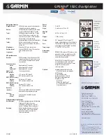
The graphic
pointer helps
you stay on
course to your
destination.
The big numbers
option makes
data fields
readable from
a distance.
Tide charts
display detailed
tide data for
the U.S.
c o m p a t i b l e
GPSMAP
®
192C chartplotter
©2005 Garmin Ltd. or its subsidiaries
Garmin International, Inc.
1200 East 151st Street
Olathe, Kansas 66062, U.S.A.
913/397.8200 fax 913/397.8282
Garmin (Europe) Ltd.
Unit 5, The Quadrangle
Abbey Park Industrial Estate
Romsey, SO51 9DL, U.K.
44/1794.519944 fax 44/1794.519222
Garmin Corporation
No. 68, Jangshu 2nd Rd.
Shijr, Taipei County, Taiwan
886/2.2642.9199 fax 886/2.2642.9099
www.garmin.com