Garmin Etrex Manual Download Page 5

Tristan Darwin Project

GPS Training - Garmin Etrex
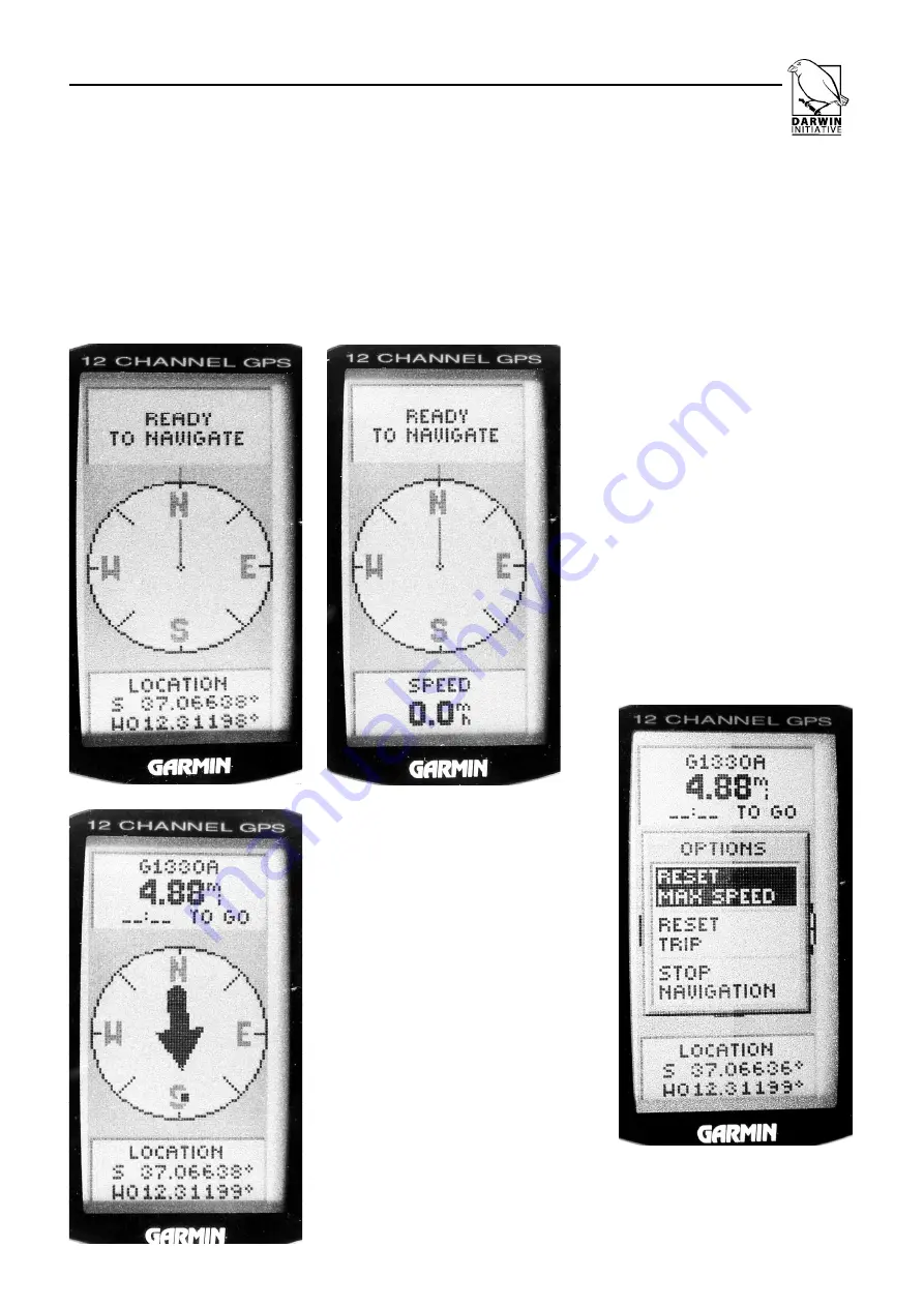
3. COMPASS SCREEN

The main part of this screen shows a repre-
sentation of a compass. In normal use this
will act like a compass showing your direc-
tion  of  travel  (see  note  on  previous  page
about its limitations). When used to navigate
to a particular waypoint or to follow a route
or track, an arrow will show you which way
you should be going. When used like this it
will also tell you how far it is to go and how

long it will take to get there at your current
speed.

There is a lot of additional information avail-
able at the foot of this screen. This includes:
Location,  Current  Speed,  Max  Speed,
Heading,  Trip  Time,  Distance  Covered,
Sunrise, Sunset etc. You can cycle through
these using the UP/DOWN buttons.

The ENTER button shows a menu
where  you  can  reset  the  trip  time
and  max  speed  as  well  as  stop
navigating  to  a  waypoint  or  route
(STOP NAVIGATION).

Pressing  the  UP/DOWN  but -
tons will change which informa -
tion is shown at the foot of the
screen eg Location and Speed
as shown here

Here the arrow shows that you
need  to  travel  South  to  get  to
waypoint  ‘G1330A’ which  is
currently  4.88  miles  away  as
the crow flies. 

No time is shown for how long
it will take to get there ( ‘--.-- TO
GO’)  because  the  unit  isn’t
moving, ie our current speed is
0 mph.

Press  the  ENTER  button  to
reset max speed or to stop nav -
igating to Waypoint ‘G1330A’.

Summary of Contents for Etrex

Page 1: ...Tristan Darwin Project GPS Training A Guide to Using the Garmin Etrex GPS...

Page 2: ...rk on a car dashboard or inside the wheel house of a boat ENTER Press this button when you want to choose an option or to say YES Pressing and holding it down will tell the unit to mark a way point at...

Page 3: ...et a fix on each satellite As more satellites are locked on the accuracy improves An Advanced Skyview can be seen as an alternative view by pressing the ENTER button and choosing this option the displ...

Page 4: ...le man who walks as you move Your position is where his head is and the map always shows what s ahead of you An arrow shows where North is This screen is most useful when you are retracing your steps...

Page 5: ...his screen This includes Location Current Speed Max Speed Heading Trip Time Distance Covered Sunrise Sunset etc You can cycle through these using the UP DOWN buttons The ENTER button shows a menu wher...

Page 6: ...his screen where you can see details of the waypoint and edit it WAYPOINTS Here you will find all the stored waypoints listed in alphabetical order This unit will store up to 500 waypoints Here you ca...

Page 7: ...ck but will begin to delete the track recorded right at the start You can check how full the memory is at the top of the screen You can save up to 10 track logs you have made The unit will ask what ti...

Page 8: ...ject in Tristan uses GMT timezone WGS84 map projection ddd ddddd position format not really the most convenient but its required for a software pack age we use called MAPINFO and True North The Interf...

Reviews: