background image

• If there are specific roads you need to use or avoid, you can 

customize the route (

Shaping Your Route

, page 5

).

• You can add multiple destinations to a route (

Adding a 

Location to Your Route

, page 4

).

Starting a Route

1

Select 

Where To?

, and search for a location (

Finding and 

Saving Locations

, page 7

).

2

Select a location.

3

Select an option:
• To start navigating using the recommended route, select 

Go!

.

• To choose an alternate route, select  , and select a route.

Alternate routes appear to the right of the map.

• To edit the course of the route, select   > 

Edit Route

, and 

add shaping points to the route (

Shaping Your Route

page 5

).

The device calculates a route to the location and guides you 

using voice prompts and information on the map (

Your Route on 

the Map

, page 4

). A preview of the major roads in your route 

appears at the edge of the map for several seconds.
If you need to stop at additional destinations, you can add the 

locations to your route (

Adding a Location to Your Route

page 4

).

Starting a Route by Using the Map

You can start route by selecting a location from the map.

1

Select 

View Map

.

2

Drag and zoom the map to display the area to search.

3

If necessary, select   to filter the displayed points of interest 

by category.
Location markers (  or a blue dot) appear on the map.

4

Select an option:
• Select a location marker.
• Select a point, such as a street, intersection, or address 

location.

5

Select 

Go!

.

Going Home

The first time you start a route home, the device prompts you to 

enter your home location.

1

Select 

Where To?

 > 

Go Home

.

2

If necessary, enter your home location.

Editing Your Home Location

1

Select 

Where To?

 > 

Saved

 > 

Set Home Location

.

2

Enter your home location.

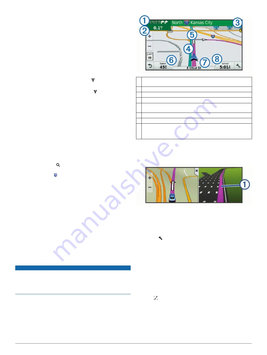
Your Route on the Map

NOTICE

The speed limit feature is for information only and does not 

replace your responsibility to abide by all posted speed limit 

signs and to use safe driving judgment at all times. Garmin will 

not be responsible for any traffic fines or citations you receive for 

failing to follow all applicable traffic laws and signs.

As you travel, the device guides you to your destination using 

voice prompts and information on the map. Instructions for your 

next turn or exit, or other action appear across the top of the 

map.
The speed limit may appear as you travel on major roadways. 

This feature is not available in all areas.

À

Next action in the route. Indicates the next turn, exit, or other action 
and the lane in which you should travel, if available.

Á

Distance to the next action.

Â

Name of the street or exit associated with the next action.

Ã

Route highlighted on the map.

Ä

Next action in the route. Arrows on the map indicate the location of 
upcoming actions.

Å

Vehicle speed.

Æ

Name of the road on which you are traveling.

Ç

Estimated arrival time.

TIP: 

You can touch this field to change the information it shows 

(

Changing the Map Data Field

, page 10

).

Active Lane Guidance

As you approach a turn while navigating a route, a detailed 

simulation of the road appears beside the map, if available. A 

colored line 

À

 indicates the proper lane for the turn.

Viewing Turns and Directions

While navigating a route, you can view upcoming turns, lane 

changes, or other directions for your route.

1

From the map, select an option:
• To view upcoming turns and directions as you navigate, 

select   > 

Turns

.

The map tool displays the next four turns or directions 

beside the map. The list updates automatically as you 

navigate the route.

• To view the complete list of turns and directions for the 

entire route, select the text bar at the top of the map.

2

Select a turn or direction (optional).
Detailed information appears. An image of the junction may 

appear for junctions on major roadways, if available.

Viewing the Entire Route on the Map

1

While navigating a route, select anywhere on the map.

2

Select  .

Adding a Location to Your Route

Before you can add a location to your route, you must be 

navigating a route (

Starting a Route

, page 4

).

You can add locations to the middle or end of your route. For 

example, you can add a fuel station as the next destination in 

your route.

4

Navigating to Your Destination

Summary of Contents for DriveSmart 50

Page 1: ...Garmin DriveSmart 50 60 70 Owner s Manual November 2015 190 01921 00_0A...

Page 2: ...nds n Maps Guarantee and n Maps Lifetime are trademarks of Garmin Ltd or its subsidiaries These trademarks may not be used without the express permission of Garmin Android is a trademark of Google Inc...

Page 3: ...ding a City 8 Finding a Location Using Coordinates 8 Viewing Recently Found Locations 8 Clearing the List of Recently Found Locations 8 Finding Your Last Parking Spot 8 Viewing Current Location Inform...

Page 4: ...ttings 17 Setting the Time 17 Language and Keyboard Settings 17 Proximity Alerts Settings 17 Device and Privacy Settings 17 Restoring Settings 17 Device Information 17 Specifications 17 Power Cables 1...

Page 5: ...o calculate accurate and efficient routes to your destinations Garmin Express is available for Windows and Mac computers 1 On your computer go to www garmin com express 2 Select an option To install o...

Page 6: ...wer saving mode while charging the battery To turn off the device completely hold the power key until a prompt appears on the screen and select Off The prompt appears after five seconds If you release...

Page 7: ...n the speed limit icon when you exceed the posted speed limit for the current road Wrong way on a one way street The device plays a message and displays a full screen warning if you travel the wrong w...

Page 8: ...citations you receive for failing to follow all applicable traffic laws and signs As you travel the device guides you to your destination using voice prompts and information on the map Instructions f...

Page 9: ...drive Trip Planner You can use the trip planner to create and save a trip which you can navigate later This can be useful for planning a delivery route a vacation or a road trip You can edit a saved...

Page 10: ...o avoid traffic delays automatically If you have disabled this option in the traffic settings Traffic Settings page 17 you can view and avoid traffic delays manually 1 While navigating a route select...

Page 11: ...low the search bar 4 Select an option To search for a type of business enter a category name for example movie theaters To search for a business name enter all or part of the name To search for an add...

Page 12: ...running Smartphone Link and log in to your Foursquare account You can view detailed Foursquare location information such as user ratings restaurant pricing information and hours of operation 1 From th...

Page 13: ...Location You can add custom categories to organize your saved locations NOTE Categories appear in the saved locations menu after you have saved at least 12 locations 1 Select Where To Saved 2 Select...

Page 14: ...stomizing the Trip Data Fields Before you can customize the data that appears in the trip data map tool you must add the trip data tool to the map tools menu Enabling Map Tools page 10 1 From the map...

Page 15: ...r device can display traffic information and help you avoid traffic delays Receiving Traffic Data Using Smartphone Link The Live Traffic service provides real time traffic data 1 Download Smartphone L...

Page 16: ...d feature you can place and answer calls using voice commands Notifications Displays phone notifications and messages on your device This feature is not available for all languages Send Locations to D...

Page 17: ...martphone Link app you must pair and connect your Garmin DriveSmart device with your phone If you did not connect to the Smartphone Link app during the pairing process you can connect to it for additi...

Page 18: ...dismissing the notification from your phone select View and select an option NOTE Additional actions are available for only some notification types and must be supported by the app generating the noti...

Page 19: ...be receiving weather data You can connect your device to the Smartphone Link app to receive weather data Pairing with Your Phone and Connecting to Smartphone Link page 12 In some areas product models...

Page 20: ...e a distraction while driving GPS Simulator Stops the device from receiving a GPS signal and saves battery power Calculation Mode Settings Select Settings Navigation Calculation Mode The route calcula...

Page 21: ...mbers up or down Language and Keyboard Settings To open the Language and Keyboard settings from the main menu select Settings Language Keyboard Voice Language Sets the language for voice prompts Text...

Page 22: ...ab on the suction cup toward you Changing the Fuse in the Vehicle Power Cable NOTICE When replacing the fuse do not lose any of the small pieces and make sure they are put back in the proper position...

Page 23: ...verviews page 1 2 Insert a memory card into the slot 3 Press it in until it clicks Data Management You can store files on your device The device has a memory card slot for additional data storage NOTE...

Page 24: ...r 15 I icons status bar 2 ID number 17 intersections finding 8 K keyboard language 17 layout 17 L language keyboard 17 voice 17 latitude and longitude 8 locations 8 16 calling 15 current 8 9 recently...

Page 25: ...ing for delays 10 traffic cameras viewing 16 travel history 17 trip information 10 resetting 10 viewing 10 trip log viewing 10 trip planner 5 6 editing a trip 5 shaping points 6 troubleshooting 18 19...

Page 26: ...5 69 33 99 39 02 36 699699 52 001 855 792 7671 0800 427 652 0800 0233937 47 815 69 555 00800 4412 454 44 2380 662 915 35 1214 447 460 386 4 27 92 500 0861 GARMIN 427 646 27 0 11 251 9800 34 93 275 44...

Reviews: