


Garmin G1000 Cockpit Reference Guide for the DA42
190-00406-06 Rev. A
Appendix
74
Fl
ig
ht
In
st
ru
m
en
ts
EI
S
N
av
/C
om
/
XP
D
R/
A
ud
io
A
FC
S
G
PS
N
av
Fl
ig
ht
Pl
an
ni
ng
Pr
oc
ed
ur
es
H
az
ar
d
Av
oi
da
nc
e
A
dd
iti
on
al
Fe
at
ur
es
A
bn
or
m
al
O
pe
ra
tio
n
A
nn
un
/
A
le
rt
s
A
pp
en
di
x
In
de
x
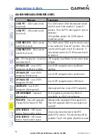
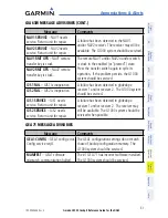
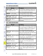
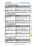
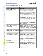
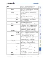
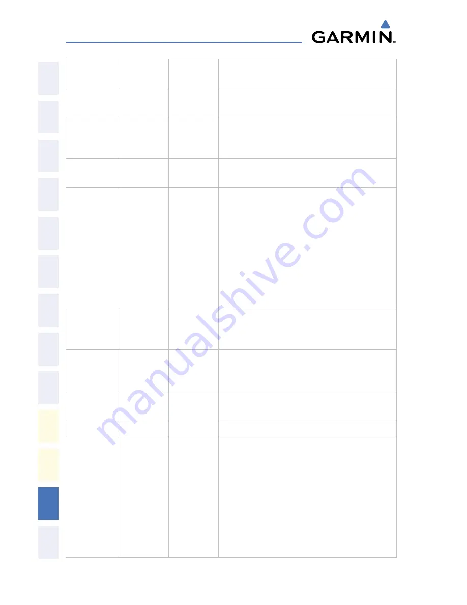
MAP
Enables second-level Navigation Map
softkeys
TRAFFIC
Displays traffic information on
Navigation Map
TOPO
Displays topographical data (e.g.,
coastlines, terrain, rivers, lakes) and
elevation scale on Navigation Map
TERRAIN
Displays terrain information on
Navigation Map
AIRWAYS
Displays airways on the map; cycles
through the following:
AIRWAYS: No airways are displayed
AIRWY ON: All airways are
displayed
AIRWY LO: Only low altitude
airways are displayed
AIRWY HI: Only high altitude
airways are displayed
STRMSCP
Displays Stormscope weather and
coverage information on Navigation
Map (optional feature)
NEXRAD
Displays NEXRAD weather and
coverage information on Navigation
Map (optional feature)
XM LTNG
Displays XM lightning information on
Navigation Map (optional feature)
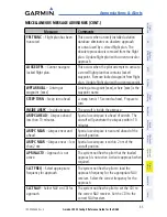
BACK
Returns to top-level softkeys
DCLTR (3)
Selects desired amount of map detail;
cycles through declutter levels:
DCLTR (No Declutter): All map
features visible
DCLTR-1: Declutters land data
DCLTR-2: Declutters land and SUA
data
DCLTR-3: Removes everything
except the active flight plan
Summary of Contents for DA42 G1000
Page 1: ...G1000 Integrated Flight Deck Cockpit Reference Guide for the DA42...
Page 2: ......
Page 4: ......
Page 95: ......