background image

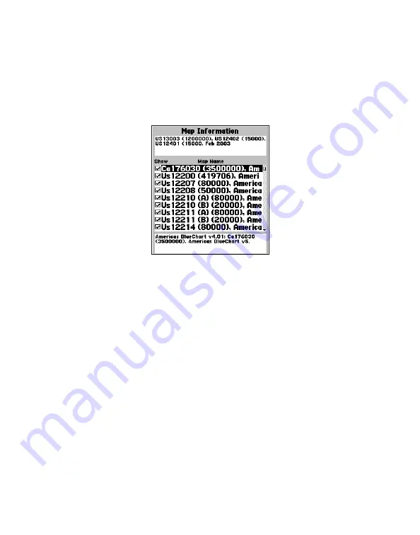
A feature of presenting data in a chart-by-chart manner is selecting only those 

paper charts that you have on hand or that you want displayed on the Garmin unit. 

By default, all available charts are displayed from preprogrammed cards. With 

MapSource, you can choose which charts to download. See your Garmin unit’s 

owner’s manual for specific steps, but the Garmin unit screen generally appears as 

shown. 

From this screen, use the Garmin unit’s on-screen cursor and press the 

ENTER

 key to 

deselect (remove the check mark from the box) the individual paper charts that you do 

not want to display.

To display chart information on your PC screen using MapSource:

1.  Place the mouse cursor within a chart boundary, and (with the selection tool) 

right-click the mouse. 

2.  Select the name of a chart, and then select 

Feature Properties

. The 

Properties window appears.

8

Summary of Contents for BlueChart

Page 1: ...BlueChart user s guide...

Page 2: ...ded that such electronic or printed copy of this manual must contain the complete text of this copyright notice and provided further that any unauthorized commercial distribution of this manual or any...

Page 3: ...e no 03 01453 and the UK Hydrographic Of ce and the Controller of Her Majesty s Stationery Of ce the British Crown 2001 GB AC 001 Garmin 24 March 2005 All rights reserved Wavey Line charts are produce...

Page 4: ...the Explorer Chartbook series WARNING No national hydrographic of ce has veri ed the information in this product and none accept liability for the accuracy of reproduction or any modi cations made the...

Page 5: ...rrent Tables which are required under the Charts and Nautical Publications Regulations of the Canada Shipping Act and which must be used for navigation within Canadian waters Of cial Canadian Tide and...

Page 6: ...ueChart 5 Viewing BlueChart Information 5 Getting Additional Object Information 6 Getting Paper Chart Speci c Information 7 Using MapSource BlueChart 9 Viewing Tides and Marine Services Information 11...

Page 7: ...w products Preprogrammed BlueChart Cards Have the ID code of your preprogrammed BlueChart card handy and connect to Garmin s Web site at http www garmin com See page 14 of this guide for information a...

Page 8: ...Garmin units This offers more exibility in choosing speci c maps within a coverage area For information about purchasing BlueChart cards see page 16 of this guide For information about transferring M...

Page 9: ...noaa com GETTING STARTED Installing a BlueChart Card Look for a compartment door or rubber weather cap on the bottom of your Garmin unit Beneath that door is a slot for the BlueChart card To insert t...

Page 10: ...data If you overwrite the preprogrammed data on a BlueChart card Garmin will not replace or recover the lost data DISCLAIMER Your MapSource unlock code is valid for use with your own Garmin unit You m...

Page 11: ...n The details and symbols in BlueChart cartography are almost identical whether you are looking at MapSource data on your PC screen or directly on your Garmin unit Viewing MapSource BlueChart on a PC...

Page 12: ...th additional information for the selected object To get additional information when using MapSource on a PC 1 Move the mouse cursor onto a map object The map object name appears in a white box 2 With...

Page 13: ...ctly from which chart and scale each displayed feature is digitized BlueChart electronic charts are a faithful reproduction of the published of cial paper charts that mariners are required to carry Bl...

Page 14: ...ual for speci c steps but the Garmin unit screen generally appears as shown From this screen use the Garmin unit s on screen cursor and press the ENTER key to deselect remove the check mark from the b...

Page 15: ...apSource you can also create waypoints routes and map sets to transfer to your Garmin unit see the MapSource Help le for more information In MapSource BlueChart data is in locked regions within each o...

Page 16: ...ly one chart at a time 1 With the Map Tool selected right click the mouse within the desired chart boundary 2 Select the desired chart name if necessary 3 Select Show This Map Only 4 To return to the...

Page 17: ...nual for compatibility and instructions on viewing tide information on your unit To view tide or marine services information using MapSource 1 Go to View then Region and then select Tides and Marine S...

Page 18: ...Select and download the desired tide and marine services maps the same way you would with MapSource BlueChart maps 2 To display the same marine properties information found in MapSource on your Garmin...

Page 19: ...re often not re ected on paper charts for years The same is true for new marinas and ports Sometimes well known local landmarks might be shown so small on the paper chart that they are indistinguishab...

Page 20: ...Product M data card X microSD card Region AE Asia East for example Japan China and Indonesia AF Africa AW Asia West CA Canada EU Europe including all of the Mediterranean Sea PC Paci c Ocean for exam...

Page 21: ...s of cards can be interchangeable for example trade in a Small BlueChart card for a Bathymetric card or vice versa For e X tra large cards you may update or trade in ONLY for the same extra large card...

Page 22: ...compile disassemble modify reverse assemble reverse engineer or reduce to human readable form the Software or any part thereof or create any derivative works based on the Software You agree not to exp...

Page 23: ...all Garmin units MicroSD cards work only with the X series Garmin handheld units Please refer to the product information for your Garmin unit at garmin com for information about which Garmin units wo...

Page 24: ......

Page 25: ......

Page 26: ...pe Ltd Unit 5 The Quadrangle Abbey Park Industrial Estate Romsey SO51 9DL U K Garmin Corporation No 68 Jangshu 2nd Road Shijr Taipei County Taiwan www garmin com Part Number 190 00246 00 Rev F For the...

Reviews: