


Ignis Operations Manual (DJI M600 Variant)
Drone Amplified
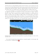
photos may not be taken at exactly those locations. However, they should be useful for
determining whether your photos will overlap or not. Adjust the transect spacing, altitude,
and cruise speed or distance between photos to get a satisfactory amount of overlap between
all of the photos along your mission.
You can also make fine adjustments to the waypoint mission, such as adding new way-
points, moving waypoints, and changing the altitude of individual waypoints, and the photo
locations will be updated to reflect those changes. For example, in Figure 105, I may want to
add more intermediate waypoints along the transect lines so that the flight path can follow
the terrain at a more consistent altitude. This would result in a more consistent spacing
between the photos.
7.15 Saving and Loading Missions
After you’ve placed some waypoints, a transect region, and/or a geofence, you can save them
as a mission file.
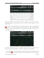
Figure 106: Touch the Save Current Mission button to save the current waypoints, transect
region, and geofence as a mission file.
Touch the Folder icon in the top bar, and then the Missions button to bring up the
missions menu, shown in Figure 106. Then touch the Save Current Mission button. This
will make the app write a comma-separated-value (.csv) file containing the mission’s in-
formation into a folder called /Drone Amplified/Missions/. A specification for this file
can be found here:
https://droneamplified.com/downloads/android/mission_file_
Last Updated March 12, 2020
Page 121


