


32
3
First, copy "VisualGPSce" from your computer to your PDA/smart phone
(Pocket PC OS). Before running the software, establish a Bluetooth connection
between the device and the terminal. Refer to P.18 for the operation.
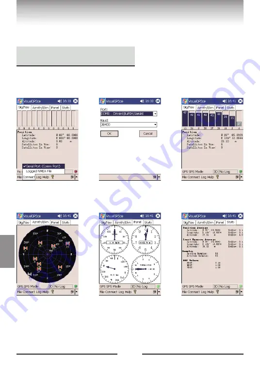
(1) Click "VisualGPS", choose
"Connect" - "Serial Port".
(2) Setup com port: baud rate:
38,400bps, COM
port(COM1~COM10*), the click
"OK" to confirm.
(3) You can check these
information in the “Sig/Nav”:
Satellites in view, Signal
intensity*2, latitude, longitude,
altitude, positioning mode*3,
etc.
(4) You can check these
information in the
“Azmth/Elvn”: satellites No.
direction, elevation, and
motion trace of each satellite in
use.
(5) The Panel interface displays
information about the speed,
altitude, direction, vertical
speed, etc.
(6) The Stats interface displays
information about the average
latitude/longitude, the last
latitude/longitude, quantity of
samples, DOP (Dilution of
Precision) values, etc.
*1
The Bluetooth port No. may vary depending on the PDA model.
*2 The signal intensity is dependent on the climate, day or night, weather, environment of placement, etc.
*3 Accurate plane positioning information is offered in the 2D mode, accurate 3D latitude information is offered in the 3D mode.
Relevant Software
Visual GPS
English
Visual GPS