background image

4.7.2.4  Manage POI (Points of Interest) 

Here you can set all the parameters of POIs that you have created and the visibility 
of the built-in POIs that come with the map. 

Manage built-in POI visibility 

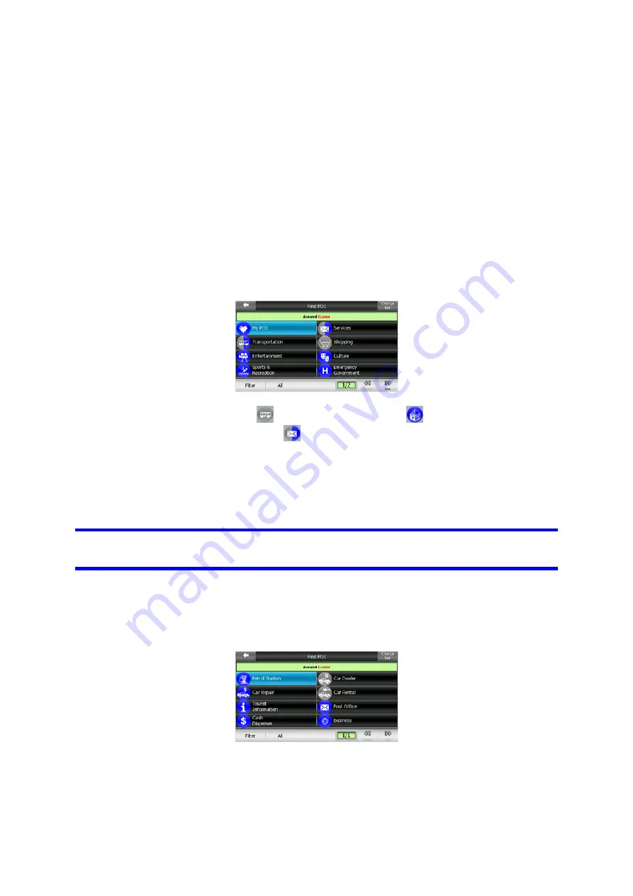
The maps in Clarion come with a huge number of POIs. Displaying all of them would 
make the maps too crowded (to see how POI items are shown on the map see  
Page 

). In order to avoid that, you can decide which POI groups to show and 

which ones to hide on the map. 

23

Clarion has a multi-level POI category system. You 

can set the visibility of the top two levels. All levels below that will be shown or 
hidden according to their respective category (i.e. you can set the visibility of Petrol 
Stations in the Services category, but all brands listed under that will either be shown 
or suppressed together). 


Groups shown with a grey icon 

 are hidden; blue icons 

 are visible on the map, 

while the ones shown in two colours 

 have some of their subcategories shown and 

some others hidden. 

If you highlight any of the POI groups by tapping them, the button in the bottom left 
corner will become Show if the POI group is hidden, or Hide if the group is shown or 
partly shown.  

Tip: To make a partly shown group fully shown, tap this button twice. First you will 
hide the whole group, and then you will have it displayed with all its subgroups. 

Tapping again the highlighted POI group (except for My POI – described later) opens 
the list of subcategories of that group. Here you cannot see bicolour subgroups, as 
visibility can only be set for the top two levels of categories. Showing and hiding a 
subgroup is done the same way as for the main groups. 


Manage My POI 

By highlighting then tapping again the My POI switch on the Manage POI main 
screen you can manage the POI groups and items that you have created. 


45

Summary of Contents for MAP670

Page 1: ...Navigation Owner s manual ...

Page 2: ...s 2006 Telstra Corporation Limited and its licensors Data Source 2006 Tele Atlas N V Austria BEV GZ 1368 2003 Denmark DAV France IGN France Great Britain Ordnance Survey data with permission of Her Majesty s Stationery Office Crown Copyright Italy Geonext DeAgostini Northern Ireland Ordnance Survey of Northern Ireland Norway Norwegian Mapping Authority Public Roads Administration Mapsolutions Swit...

Page 3: ...rt Guide first and start using Clarion right away This document is the detailed description of the software Although Clarion can easily be discovered by experience it is still recommended that you read through this manual to clearly understand the exact function of each button and icon 3 ...

Page 4: ... 1 16 Main menu Navigation Menu 4 2 17 About screen 4 3 17 The map 4 3 1 17 2D and 3D map views 4 3 2 18 Zoom levels 4 3 3 19 Daylight and night colour schemes 4 3 4 20 Streets and roads 4 3 5 21 Other objects 4 3 6 21 Current position and Lock on Road 4 3 7 22 Selected map point also known as the Cursor 4 3 8 22 Marked map points Pin 4 3 9 23 Visible POIs Points of Interest 4 3 10 24 Road safety ...

Page 5: ... 17 38 Next street Next settlement No 19 4 5 18 38 Approaching next turn No 20 4 5 19 38 Current speed limit No 21 4 5 20 39 Bluetooth or Phone call status No 22 4 6 39 Route Information screen 4 6 1 40 Route data displayed for destination and via points 4 6 1 1 40 Route line 4 6 1 2 40 Distance Left 4 6 1 3 41 Method 4 6 1 4 41 Time Left 4 6 1 5 41 Estimated Arrival 4 6 1 6 41 Destination Via poi...

Page 6: ...9 5 60 Change the settings of the camera warning 5 61 Settings 5 1 61 General settings 5 1 1 61 Safety Mode 5 1 2 62 Set Favourite Destinations 5 1 3 62 Automatic Night Colours 5 1 4 62 Alerts 5 1 5 63 Warn When Speeding 5 1 5 1 63 Speeding tolerance 5 1 5 2 63 Alternative speed limit 5 1 5 3 63 Alternative speeding tolerance 5 1 6 64 Enable Safety Cameras 5 1 6 1 64 Audible Warning 5 1 7 64 Route...

Page 7: ...gement 5 6 3 74 Smart Zoom 5 6 3 1 75 Smart Zoom settings 5 6 3 2 75 Enable Overview mode 5 6 3 3 75 Restore Lock to Position and Smart Zoom 5 6 4 76 Route options 5 6 4 1 77 U turn penalty 5 6 4 2 77 Cross border planning 5 6 4 3 77 Keep position on road Lock on Road 5 6 5 77 User data management 5 6 5 1 77 Backup Data 5 6 5 2 78 Restore Data 5 6 5 3 78 Remove Pins 5 6 5 4 78 Clear Data 5 6 5 5 7...

Page 8: ...6 3 2 85 Find in History 6 3 3 86 Find Coordinates 6 3 4 87 Find a POI 6 3 5 89 Find one of the Favourites Home Work 7 90 Troubleshooting guide 8 92 Glossary 8 ...

Page 9: ...er if you need to change route parameters Clarion has a built in optional Safety Mode that will prevent you from using the screen functions if your car is in motion Unless a passenger will be the only one to operate Clarion we strongly encourage you to turn on the Safety Mode It is also important that you look at the display only if it is absolutely safe to do so You should always observe traffic ...

Page 10: ...nctions of the program by using hardware and screen buttons With the help of these buttons you can travel through all the screens of the program Most of the screens especially menu functions and settings can be accessed from several other screens minimising the number of actions needed to reach the desired function When using Clarion you do not need to double tap or tap hold the touch screen as th...

Page 11: ...s running when you turn the device back on Clarion will continue the navigation as soon as the built in GPS determines the location again While the device is switched off the GPS will not work no position will be calculated track log will not be saved and navigation will stop 3 1 2 Toggling between the Map and Cockpit screens You may want to temporarily switch between the Cockpit screen and the Ma...

Page 12: ... sometimes together with a short description in a horizontal stripe with arrows at both ends The arrows are buttons Tap to move left in the list or tap to move right You need not confirm your selection As soon as you leave the screen the selected value becomes effective 3 2 3 Sliders When a feature has several different unnamed numeric values Clarion will show sliders that look like analogue poten...

Page 13: ...tus 3 2 5 Special switches Some switches behave differently Instead of being dark when not selected the light turns red and the lamp becomes crossed out to emphasize the prohibition of use Furthermore the switches used for the road types to be included or avoided when planning a route on the Route Parameters screen Page cannot be changed for some vehicle types When such a vehicle is selected not o...

Page 14: ...look pleasant 3 2 7 1 ABC type keyboards These keyboards contain only letters Latin Hebraic Greek or Cyrillic If you wish to enter numbers you need to tap the Keys button to switch to the numeric keyboard Use Backspace arrow pointing left between Space and Keys to delete the last letter you have entered if you have made a mistake tap Space to enter more words and hit Done to finish entering the te...

Page 15: ...eyboard The numeric keyboard only contains numbers on huge buttons The special keys you find on the other keyboards except Space are available here as well Although QWERTY type keyboards also contain number keys when entering a house number the program offers the more convenient numeric keypad 15 ...

Page 16: ...re very rarely while using the program Screens are also accessible from each other to reduce the number of actions needed to initiate a function or change a setting Most parts of the program are directly accessible from here by using the buttons described below No Content 1 Destination Button to open Find menu 2 Button to open Map screen 3 Button to open Cockpit screen 4 Current position 5 Current...

Page 17: ...re optimised for different uses The map they display is common The elements of the map are described here For the controls and special functions of the two map screens see Page 28 The current version of Clarion is primarily intended for land navigation That is why maps in Clarion look similar to paper roadmaps when using daytime colours and 2D map mode However Clarion provides much more than regul...

Page 18: ...Finally 2D view will be reached When you zoom back in 3D view will gradually return Note Using the Advanced settings you can force Cockpit mode to always start in 3D Track up view Page You can still rotate and tilt the maps in either mode but the next time you enter this screen the preset look will reappear Similarly you can force Map mode to always start in 2D North up view 72 4 3 2 Zoom levels C...

Page 19: ...emes The different colour schemes let you adjust Clarion to the brightness of the environment Use the daylight and night colour schemes accordingly Daylight colours are similar to paper roadmaps while the night colour schemes use dark tints for large objects to keep the average brightness of the screen low with carefully selected colours to still keep you informed about all the necessary informati...

Page 20: ...oadmaps is also convenient when it comes to streets the most important elements of the map concerning navigation Clarion uses similar colour codes to those you are accustomed to and the width of the streets also refers to their importance so it will not be difficult to tell a highway from a small street Streets and roads have names or numbers for identification Of course this information can be di...

Page 21: ... other navigating function than to help you recognise your location on the map These are surface waters large buildings forests etc Tip These objects are normally displayed using textured polygons that look natural to the eye You may wish to switch the textured display off Page to free some of the resources of your 66 PNA by replacing textures with plain coloured surfaces 4 3 6 Current position an...

Page 22: ...position 4 3 7 Selected map point also known as the Cursor If you tap the map somewhere or select a specific item in Find it will become the selected point on the map marked with a small red dot and permanently radiating red circles to make it conspicuous at all zoom levels even when it is in the background of a 3D map view You can use this point as starting point via point or destination of your ...

Page 23: ...ousands of built in POIs and you can create your own POI database as well Having all of them displayed on the map would make the map too crowded To avoid this Clarion lets you select which POIs to show and which ones to hide Page using their categories and subcategories 45 POIs are represented by icons on the map For a built in POI it is the icon of the subcategory of the actual POI For points you...

Page 24: ... a particular POI in the list tap the blue i icon on the right If you have too may POIs nearby this list may not be complete In the Cursor menu Page 47 35 there is a button called POI that leads you to the screen of all nearby POI items There you can open them one by one to see their details and select any of them as a route point 4 3 10 Road safety cameras Road safety cameras such as speed camera...

Page 25: ...displayed in light green red It is always the most conspicuous part of the map even when in the background of a 3D map view The line of the route is displayed on the driving side of the road for two way and on the axis in case of one way streets When the map is zoomed in and the line is wide enough small arrows show the direction of the route This can be useful if you preview the route before star...

Page 26: ...d The virtual sky on the left represents the currently visible part of the sky above you with your position as the centre The satellites are shown at their current positions The GPS receives data from both the green and grey satellites Signals from the grey satellites are only received while green ones are used by the GPS to calculate your current location On the right you can see the satellite si...

Page 27: ... Different colours represent different signal quality black with a red cross means there is no connection with the GPS device This should never be the case if your device has a built in GPS red means the GPS is connected but no GPS position is available yellow means 2D reception A GPS position has been acquired Clarion is ready for navigation but the GPS is using enough satellites for calculating ...

Page 28: ...d controls are optimised for different purposes The Map screen is to be used mainly without a GPS to browse the map create user POI items or to plan your route based on map points The Map screen is designed to give you the maximum map area This screen is usually used in 2D North up mode You can set Clarion so it always opens the Map screen in 2D North up mode Page 72 73 The Cockpit screen is for d...

Page 29: ...PS position and heading is inactive Re enables Lock to Position Smart Zoom 7 Selected map point Cursor Opens Popup Info and Cursor menu 8 Map only Map scale Zooms in out by dragging 9 n a Menu Find Quick Route Main 10 Map orientation and Overview Switches North up Track up and Overview 11 GPS position quality Opens the list of TMC messages 12 Battery status Opens settings 13 Sound on or muted Open...

Page 30: ...oute is active Contents differ when a route is active Appears only when a route is active Appears only when a route is active and the next turn is near Appears only if speed limit is known for the current road 4 5 1 Turn preview No 1 On the Cockpit screen this field shows a graphic illustration of the next manoeuvre For example when you approach a turn an arrow will show whether it is a slight nor...

Page 31: ...ly after a few seconds in case of the Cockpit screen Page 75 4 5 3 Tilt up and down No 4 5 These semi transparent buttons are only displayed if Zoom Tilt is enabled in the Quick menu Page 44 This function modifies the vertical viewing angle of the map in 3D mode You can change the angle in a wide range starting from a top down view 2D view is seamlessly integrated all the way to a flat view that l...

Page 32: ...an set a delay time after which Clarion pushes the Follow button for you on the Cockpit screen automatically Page This can be turned on for re enabling both Lock to Position and Smart Zoom 75 4 5 5 Cursor No 7 As described earlier Page if you tap the map somewhere or select one specific item in Find it will become the selected point on the map marked with a small red dot and radiating red circles ...

Page 33: ... to show the new rotation mode Tap the icon again to enter Overview mode This mode looks similar to the North up mode with one difference the zoom level in this mode has a fixed default to give you a better look of where you are on the map You can change the zoom level at any time this will not cause the Follow button to appear but when entering Overview mode later the default zoom level will be r...

Page 34: ...shows there is a GPS position and navigation is possible When only one arc is shown the position is 2D no altitude available and position error may be significant yet Clarion is ready to navigate A black dish and two arcs represent a 3D GPS position Clarion is ready to navigate When small car symbols are displayed under the dish TMC information is available 4 5 10 Battery status No 12 The status o...

Page 35: ... the screen anywhere stops the simulation 4 5 13 Cursor menu No 15 The Cursor is the selected point on the map marked by a red dot and radiating red circles around it or the current GPS position when it is available and Lock to Position is enabled When you tap the screen to place the Cursor the Cursor menu pops up automatically to give you the list of possible functions you can use the Cursor for ...

Page 36: ...ome fuel at B or want to influence the direction of the route This menu point works only if a route is already active Remove Via removes the via point near or at the Cursor The route will be recalculated immediately excluding the deleted point This menu point replaces Add Via and is available only if the Cursor is near or at a via point Add Dest add a new destination to be reached after the previo...

Page 37: ...te or navigating following an active route While cruising the fields show the present speed the current speed limit and the time of day While navigating a route these fields show the estimated time needed to reach the destination ETE the distance to destination and the estimated arrival time at the destination ETA by default You can choose what to display in these three fields during navigation by...

Page 38: ...ll appear next to the name of settlements to help you tell them apart from street names This field is only displayed when navigating a route 4 5 18 Approaching next turn No 20 This bar is only visible when approaching the next route event It appears on the screen to visualise the distance when you get closer than 300 meters 1000 feet to the next turn and it remains visible till you reach the turn ...

Page 39: ...ue navigation without stopping the phone call with the button in the top right corner Then navigation continues without voice guidance sound is reserved for the phone call and an icon depicting a telephone handset is shown here Tap the icon to pause Clarion and return to the phone call screen When you hang up the call the icon returns to the blue Bluetooth logo 4 6 Route Information screen The Rou...

Page 40: ... to the right giving you visual feedback of your journey When you reach a via point it becomes the starting point of the route the past will be deleted the line with all the other via points will be modified instantly and the arrow jumps back to the left When Clarion needs to recalculate the route the arrow will not jump back to the left as when reaching a via point but it may drift a bit as the l...

Page 41: ...Estimated Arrival This is an estimated value that can also be displayed in one of the Route data fields on the Cockpit screen as ETA to destination It shows the estimated arrival time at the final destination of the route based on information available for the remaining segments of the route The calculation cannot take into account traffic jams and other possible delays If via points exist tap and...

Page 42: ...te near the start or the destination This icon warns you that Clarion had to recommend a route that does not match all your preferences given at the Route Parameters settings The recommended route contains areas only accessible to pedestrians The recommended route contains unpaved roads The recommended route contains roads that require a permit or permission to enter Information any other piece of...

Page 43: ...ly used functions of Clarion 4 7 1 Find tab The first page of the Menu is Find It lets you select a destination without first having to locate it on the map The Find menu will be described in detail later here Page 79 4 7 2 Quick tab This provides quick access to some configurable options 4 7 2 1 3D Map switch When the green light is on the map shows a perspective view When the green light is off ...

Page 44: ... according to the new state of the button 4 7 2 2 Zoom Tilt switch When the green light is on additional transparent buttons Page and Page 31 31 appear on the left side of the map screens for zooming and tilting without the use of hardware buttons The Tilt buttons appear only at higher zoom levels If you zoom out they disappear 4 7 2 3 Night Mode switch Turn on or off the night colours manually to...

Page 45: ...ether Groups shown with a grey icon are hidden blue icons are visible on the map while the ones shown in two colours have some of their subcategories shown and some others hidden If you highlight any of the POI groups by tapping them the button in the bottom left corner will become Show if the POI group is hidden or Hide if the group is shown or partly shown Tip To make a partly shown group fully ...

Page 46: ...similarly to built in POIs you have the possibility to show or hide all POIs of the selected category on the map Groups with a blue icon are displayed groups with a grey icon are hidden New you can create a new My POI group by tapping this button You need to select an icon a name and the maximum zoom level at which the POI is still visible on the map provided you let the POI group be displayed at ...

Page 47: ... a few letters of the desired POI name When the number of mat items can fit in one page Clarion will automatically display the list If you ta any time before this happens you receive the list of matches on multiple pages ABC Distance by tappin Here you have the following options OK if you tap this button the map screen returns with the selected POI in the middle Edit you can edit the attributes na...

Page 48: ...time when it was recorded You can change their name to something more meaningful if you wish Each track log has a colour shown to the left of its name when the track log is visible on the map If the track is not visible an underscore character is shown here Tapping the line of the highlighted track log will toggle between showing and hiding that log The track log will be drawn on the map using the...

Page 49: ...the sa g ved track log on the map A reen icon Page 35 will appear on the map screens to let you know it is not a fly you parameters ou do not need such a ry is used by to turn of over but a simulation based on a real saved log Delete you can delete a track log if it is not needed any more Clarion will ask to confirm this action Track log options this button in the upper right corner leads to a set...

Page 50: ...memory card if inserted and they cannot be shown or replayed in Clarion They are for post processing needs should you have any Be careful when saving native GPS data as it can soon eat up available memory 4 7 3 Route tab This menu contains options to manage different settings in the program 4 7 3 1 Recalculate This menu point is only available if an active route exists and GPS position is present ...

Page 51: ... not want to actually reach it or you have already almost reached it and Clarion still keeps on navigating towards that point When there are no via points left only the destination the name of this button turns to Delete Route and it cancels Note This function is to give you an alternative for the next section of the recommended route To change later parts of the route or to avoid specific streets...

Page 52: ...tton once you will see the list of events that need your attention i e the list of manoeuvres during the route These are the events shown in the Turn preview field and announced by the voice instructions Route summary tapping the Mode button again will show an overview of the Display modes items are always shown with all information available including pictograms of the needed action and distance ...

Page 53: ...ey are similar to the ones in the Bypass list of the Recalculate menu Page but these can also be used for distant parts of the route 50 Note You need not open Itinerary if you run into a roadblock or traffic jam To get an immediate alternative route use the Bypass function of Recalculate Page 50 Note When you use this feature Clarion will keep on excluding the same part of the until you manually d...

Page 54: ...you can optimise the order in which you will drive through the via to save you time and fuel Optimisation is for via points only Your starting point and destination remain in their positions of 4 7 3 6 Info This button opens the Route In Page 39 This screen shows information about the current route and has a few additional options to check and modify your active route automatically to let you sear...

Page 55: ...not need to set anything in the program The receiver will automatically search the FM radio stations for TMC data and the decoded information will immediately be used in route planning The formation that may affect your route the program Tap the small satellite dish icon on the Main menu Map or Cockpit screen to open this window 4 8 1 List of TMC mess The main screen of the TMC section is the list...

Page 56: ...gnal strength bars on the GPS Data screen If there aren t FM CCIR radio band 87 5 108 M information the indicator will show the frequency and detailed information for the TMC station If you wish to receive TMC data f radio station will be added to the list of excluded stations Clarion will start searching for another TMC station and will always skip the excluded station in the future 4 8 2 3 Show ...

Page 57: ... speed cameras and red light cameras ar ou can fine tune this warning in General settings anually It is described in detail d cameras may be prohibited by law in certain countries Warning Detecting spee Your device can be considered as a speed traps warning system if it contains radar data 4 9 1 Camera types There are four types of speed cameras 4 9 1 1 Fixed cameras Some cameras stand by the road...

Page 58: ... same as for the fixed hey work lik proximit cameras These cameras are displayed with the following symbol 4 9 1 4 Section control cameras These cameras work in pairs and do not measure your current speed but your verage speed between the two cameras Both will identify your car and record the exact time you pass them The difference between the two points of time will be used our average speed is m...

Page 59: ... with the following symbol 4 9 2 Controlled traffic direction the traffic both directions or even se an intersection when they are mounted on a rotating base Clarion warns you only if ured or possibly measured direction The measured direction of the cameras is displayed with the following symbols The different cameras can measure the speed of one direction of veral directions in you drive in a mea...

Page 60: ... set its parameters To edit an existing camera find it at the end of t tails Tap Delete on this screen if you wish to cancel the camera eters of existing o the POI button in the Cursor menu st of POIs around the selected he POI list and tap it A new screen will open with its de a warning ng and fine tune its 4 9 5 Change the settings of the camer You can turn on and off the camera warni settings i...

Page 61: ...con Page 16 34 while some of its sub screens are accessible from other parts of the program 5 1 General settings These are the basic settings of Clarion 5 1 1 Safety Mode Safety mode will disable the touch screen above 10 km h 6 mph to keep your attention on the road You are still able to use the hardware buttons but you cannot set a new destination or change the settings When you disable Safety M...

Page 62: ...longitude position or both Note If you tap either of your favourite destinations in the Main menu Page 89 before defining it Clarion will offer to take you to this screen to set it up 5 1 3 Automatic Night Colours Using the automatic night mode Clarion will change between the daylight and night colour schemes a few minutes before sunrise and a few minutes after sunset based on the time and locatio...

Page 63: ...lider will change depending on which mode you have chosen Both positive and negative values can be given in either offset or percentage mode 5 1 5 2 Alternative speed limit If the speed limit of the current road segment equals or is above this limit the speed warning will use the alternative tolerance instead of the previous one Move the slider to its rightmost position to turn off the alternative...

Page 64: ...when you approach one of these cameras Note Detecting the location of speed cameras may be prohibited by law in certain countries or regions Be sure to check if it is legal to turn on this warning or not before doing so 5 1 6 1 Audible Warning You can disable the audible warning have a simple warning when you are warned only if you exceed the speed limit when approaching a camera or a complex soun...

Page 65: ...t and recalculate the route without it If you have only one target left the label of the button will be Delete Route and it will end navigation Bypass if you have deviated from the original route because of a traffic jam or roadworks you can instruct Clarion to avoid the original route for a specified distance Cancel you can exit without recalculating the route Navigation stops and will be activat...

Page 66: ...reet names are displayed either aligned with the street or on signposts stuck into the streets Page 20 If you switch these signs on it will be easier to recognise your location on the map if you turn them off it will be easier to see the road geometry Note You can only disable street names and POI icons if Clarion follows your position As soon as you move the map and Lock to Position Page is disab...

Page 67: ...unds are turned on the slider on the right will adjust their loudness In its leftmost position the key sounds are suppressed in its rightmost position they are played at the master volume level Note The sound effects of Clarion are context sensitive They will be different if for example you open or close a window or you enable or disable a setting They will even let you know if you have entered en...

Page 68: ...ge Settings here determine how routes will be calculated This screen is directly accessible from the Route Information screen Page 39 5 4 1 Method Use the handle to set the speed of the route calculation In the leftmost position the route may not be optimal but the calculation will be very fast Sliding it to the right will result in more accurate routing in an increased amount of time Note Since C...

Page 69: ...ing some of the road types will be excluded from the route e g motorways for pedestrians or some of the restrictions may not be taken into account e g emergency vehicles have no restrictions Furthermore when Bus or Lorry is chosen the program assumes that high speeds cannot be achieved and this information is taken into account when calculating the route the estimated time enroute ETE and the esti...

Page 70: ...oad types this is a type of action Most drivers prefer to replace them with a few normal left and or right turns in the next few junctions so it is disabled by default Turning back on dual carriageways is not considered as a u turn Note If you are not totally against u turns leave them on here and add a certain penalty equivalent extra distance to travel in Advanced settings Route options Page 77 ...

Page 71: ... 5 5 2 Voice language This button shows the current language of the voice guidance By tapping the button you can select from a list of available languages and speakers Tap any of these to hear a sample voice prompt Just tap OK when you have selected the new spoken language 5 5 3 Units You can set the distance units to be used by the program Clarion may not support all of the listed units in some v...

Page 72: ...elements or how it presents the screens 5 6 1 1 2D in Map mode and North up orientation The normal use of the Map mode is to browse the map and look for different places on it It is usually done in a top down view having north towards the top of the map By default Clarion uses the same look for the map in both Map and Cockpit modes Use this switch to instruct Clarion to always open the Map mode in...

Page 73: ...depends on the type of object you have searched for For example in the case of a city search the zoom level will show you the whole settlement or at least a significant part of it around its centre Selecting a POI a junction or an exact address will give you a closer look with only a few streets on the display 5 6 1 4 Coordinate display format Positions are sometimes displayed with their addresses...

Page 74: ...helps you achieve a longer battery life 5 6 3 Smart Zoom Smart zoom is a lot more than just a usual automatic zoom While navigating a route when approaching a turn it will zoom in and raise the view angle to let you easily recognise your manoeuvre at the next junction If the next turn is at a distance it will zoom out and lower the view angle to be flat in order to let you see the road in front of...

Page 75: ...n in the middle again Note when this automatic feature is disabled you can still enable the Overview mode manually as described here Page 33 5 6 3 3 Restore Lock to Position and Smart Zoom As described at the hardware buttons and the map screen functions you can move rotate tilt and zoom the map during navigation In these cases a Lock icon Page appears on the screen 32 As already mentioned you can...

Page 76: ...estore Lock to Position the view changes smoothly Note Smart Zoom can only be re enabled when it is activated at the top of this page With Smart Zoom turned off neither does the Follow button appear nor will the view return to its previous state if you zoom or tilt the map Delay before restoring You can set the timeout for both Restore Lock to Position and Restore Smart Zoom here Shorter delays ar...

Page 77: ...all GPS errors For pedestrian use you may consider disabling Lock on Road to make Clarion always show your exact position Note By turning off Lock on Road you also turn off the GPS position error filtering The position shown on the map will be subject to all position errors and position fluctuations 5 6 5 User data management Everything that was saved pins My POIs Favourites track logs etc or modi...

Page 78: ...one by one you can tap this button to restore the state of Clarion to the latest backup By tapping this button you will lose all of the changes made since the time of the latest backup Clarion will warn you about this before overwriting the current database with the backup 5 6 5 3 Remove Pins Normally Pins can be deleted one by one Since they are shown at all zoom levels and you may end up having ...

Page 79: ...ockpit mode and start navigation 6 1 Destination Main menu As just mentioned the fastest way to find your destination and start navigating is to tap Destination in the Main menu Page This will put you on the Find screen and as soon as you pick a destination 16 Clarion will immediately show the Cockpit screen and start navigation This means that if you plan your route to one of your Favourite desti...

Page 80: ...structure of the address search module There are five levels Country City Street and Address The state level appears only in case of some countries The list of recent cities and states is the entry point of the module The green rectangles are the exits You can complete your search by selecting the centre of a settlement the midpoint of a street an intersection of two roads or an exact address You ...

Page 81: ...find on the list tap Other City in the top right corner This will take you to the city name or postcode input screen where you can select the desired city by entering a few letters of its name or some digits of its postcode then select from the list of results automatically given by the program if the matching items can be displayed on one page or displayed on more pages if you tap Done after ente...

Page 82: ...n stops searching and displays 300 at the right end of the input line Enter more letters to narrow the list Note When the name of the settlement contains a character that is not available on the keyboard e g apostrophe or dash Clarion considers it a space that splits the word That is why you can search for Hilde Rygol Siedlung with all the following search criteria H R S Si H or Hi Ry Tip If you h...

Page 83: ...e inactive and grey Selecting the centre of the settlement If you wish to navigate to the settlement displayed in the top centre of the screen just tap Done before entering any letters The search result will be the centre point of the city where its name is displayed on the map Note This point is not the geometrical centre but an arbitrarily selected point chosen by the creators of the map usually...

Page 84: ...lect a street you are automatically taken to the House Number Input screen Page 84 Selecting a house number from several streets If you are uncertain which of the result streets contain the house number you are looking for tap Find In All and proceed to the House Number Input screen without selecting the street first Enter the house number tap Done and a list appears with only those streets where ...

Page 85: ...p Done to rue d Uzès Paris France is selected 6 3 2 Find in History they all appear in the History list This list is ordered by the time the points were last used The most recently used locations are always at the beginning of the list abroad In this example y an address in Paris Fran be taken after entering the Find Address section Tap France in the list Now select the city in France Enter Paris ...

Page 86: ...re always shown in the format configured in Advanced settings Display options Page but you can enter the coordinates in any of the three formats You can even enter the latitude and longitude in different formats 73 Entering a latitude longitude pair is easy The left field contains the latitude It starts with an N North or S South letter This tells Clarion whether the point is in the Northern or th...

Page 87: ...els altogether The search will be carried out around a certain reference point Always look at the current reference point shown in the green field above the POI category buttons and confirm that it matches what you want To change the reference tap the Change ref button in the top right corner Once you tap the Change ref button you are presented with these choices Address you can specify an address...

Page 88: ...ring up a text input screen to let you narrow the list of POIs If you tap Search in the list of subgroups you will only search in the group you are already in See all POIs of the current group in a list tapping the All button opens the list of all points in the group or subgroup you are already in Use the Next and Previous buttons to browse through the list Search results are ordered by their dist...

Page 89: ...one as a handsfree device a new Dial button appears if a telephone number is displayed for the selected POI Tap Dial and your PNA will call the phone number displayed for this POI 6 3 5 Find one of the Favourites Home Work If you have already set up your favourite destinations in General settings Page you can select either of them by simply tapping the button with the name on it 62 Using the Desti...

Page 90: ...re that moves the map back to your actual location 32 The blue yellow when using night colours arrow shows my location but I cannot see the route green or red line and no voice instructions are announced It is likely that you have no active route Check the upper left corner of the Cockpit screen Page if you can see the indication for the next turn or not If this field is blank you have no route pl...

Page 91: ...without a warning message If you already have a multi point route Clarion warns you before deleting the whole route I enabled the speed warning as soon as I bought the product but I have just been fined for speeding because Clarion failed to warn me For an accurate speed warning the actual speed limits of each street and road must be present correctly on the map This is a relatively new feature of...

Page 92: ...osition in the sky This information is shown in Clarion on the GPS Data screen Page Use it as a general reference only Note that several other factors affect the real accuracy some of which the GPS is incapable of estimating e g signal delay in the ionosphere reflecting objects near the GPS device etc 26 Active route A route is an itinerary planned to reach your chosen destinations A route is acti...

Page 93: ...nts the time needed to reach your destination based upon calculations using the remaining part of the route and available information of the roads used This estimation can be used only as a general reference It will not be able to take into account your future speed or the traffic delays In Clarion this value is shown as Time left on the Route Information screen Page 41 GPS Abbreviation of Global ...

Page 94: ...econds depending on your GPS settings When you start the recording position data are saved in the database until you stop recording it This set of sequential GPS positions is called track log Each set of consecutive positions has a name originally it is the time of recording but you can change it to any name you like and a colour in which it can be displayed on the map Later you can replay the jou...

Reviews: