background image

Specifications include Brunton model 5009 & 5010 GEO transits.

Magnetism:  

NdFeB Magnet

(rare earth magnet)

Accuracy:

Bearing -- +/- 1/2° accurate
Inclination  --  +/- 1° accurate (30 minute readable)

Size (Closed):

Length -- 9.45 cm (3.72 in.)
Width -- 7.06 cm (2.78 in.)
Height -- 3.43 cm (1.35 in.)

Weight -- 289 g (10.2 oz.)

Engraving -

Personalize the Brunton GEO Transit with engravings (up to 18 characters,

including spaces).  Call Brunton at (307) 856-6559 for details.

Balancing -

Brunton GEO transits must be balanced for use in specific regions of the world.

If using the GEO outside North America, the GEO’s needle may need to be balanced.  Call
Brunton at (307) 856-6559 for details.

Repair / Service -

Brunton’s repair department is capable of handling repairs, or conversions

of any genuine Brunton Pocket, or GEO transits.  Periodic maintenance and calibration is high-
ly recommended and will prolong the life of your pocket transit.  Call Brunton at (307) 856-6559
for details.

A description of the claim, shown in Figure 40, would read:

Beginning at Corner #1, NE corner: Thence 600 feet, 290° to Corner #2.  Thence 1,500 feet,
200° to Corner #3.  Thence 600 feet, 110° to Corner #4.  Thence 1,500 feet, 10° to Corner #1.

Inches

1/8
1/4
3/8
1/2
5/8
3/4
7/8
1
2
3
4
5
6
12

Feet

0.0104
0.0208
0.0313
0.0417
0.0521
0.0625
0.0729
0.0833
0.1667
0.2500
0.3333
0.4167
0.5000
1.0000

mm

3.1750
6.3500
9.5250
12.700
15.875
19.050
22.225
25.400
50.800
76.200
101.60
127.00
152.40
304.80

cm

.31750
.63500
.95250
1.2700
1.5875
1.9050
2.2225
2.5400
5.0800
7.6200
10.160
12.700
15.240
30.480

Conversions

1 inch = 2.54 centimeters
1 foot = 12 inches
1 foot = 0.305 meters
1 yard = 3 feet
1 yard = 0.914 meters
1 chain = 66 feet
1 mile = 5,280 feet
1 mile = 80 chains
1 mile = 1.609 kilometers
1 acre = 43,500 feet

2

1 acre = 0.4047 hectares

Conversions

1 centimeter = 10 millimeters
1 centimeter = 0.01 meters
1 centimeter = 0.394 inches
1 meter = 100 centimeters
1 meter = 3.281 feet
1 meter = 1.094 yards
1 kilometer = 1,000 meters
1 kilometer = 0.6214 miles
1 hectare = 10,000 meters

2

1 hectare = 2.471 acres
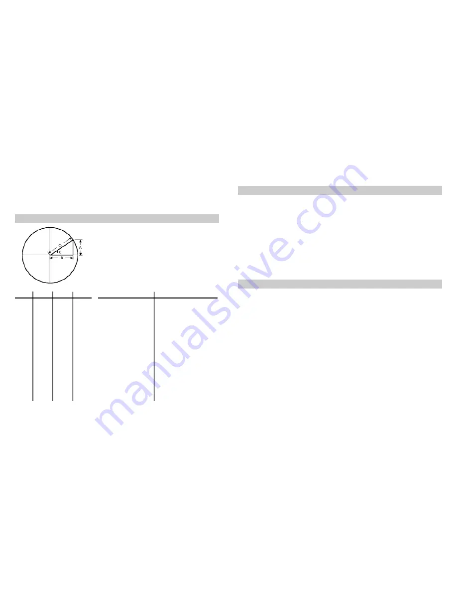
SIN(

θ

) = A/C

CSC(

θ

) = C/A

COS(

θ

) = B/C  

SEC(

θ

)

C/B

TAN(

θ

) = A/B

COT(

θ

) = B/A

A  =  Side opposite angle 

θ

B  =  Side adjacent to angle 

θ

C is the hypotenuse
C

2

= A

2

+ B

2

25

26

10 -- Reference Materials

11 -- Specifications

12 -- Service

Summary of Contents for GeoTransit

Page 1: ...tional Measurements 18 9 Prospecting 19 10 Reference Material 25 11 Specifications 26 12 Service 26 i Copyright BRUNTON 2001 Printed in U S A form 11 GEO rev 0109 Owner s Purchase Record Model _______...

Page 2: ...h is induction damped allowing the needle to seek magnetic north and come to a complete rest in a minimum amount of time 1 3 Graduated Circle Fig 2 In combination with the needle the 1 graduated circl...

Page 3: ...ng Why are EAST WEST switched The GEO Transit is a direct reading compass Read azimuth directly where the needle points on the graduated circle With the large sight toward the object read azimuth dire...

Page 4: ...ca only Use the isogonic chart a current United States Geological Survey USGS Bureau of Land Management BLM another map or a computer program to determine magnetic declination at your position Declina...

Page 5: ...st declination rotate graduated circle clockwise from the zero pin Fig 9A For West declination rotate graduated circle count er clockwise Fig 9B If magnetic declination is 0 no adjustment is necessary...

Page 6: ...er the body 4 Press left forearm against your waist and steady with right hand 5 Look just over the large sight and at the object through window opening on mirror Fig 16 Adjust mirror and large sight...

Page 7: ...bubble is centered in the long level 6 Read inclination at vernier s center line The Brunton GEO Transit is capable of measuring vertical angles with an accuracy better than 1 with readings to 10 min...

Page 8: ...ly height calculation as shown in figure 24A or 24B Note Do not calculate tangent of an angle by adding tangents of two smaller angles Example Tan 60 Tan 30 Tan 30 Find Tan 60 from a table use a calcu...

Page 9: ...on its side and along on the rock surface so the vernier scale is at the bottom Fig 27 3 Adjust vernier until bubble is centered in long level 4 Read dip angle at the vernier s center line bottom sca...

Page 10: ...the GEO transit 1 On a USGS topographic map place a point at a starting position and an X at a destination 2 Draw a line connecting both marks 3 At the starting point draw a true north line Fig 31 Use...

Page 11: ...d center of each side line NRS 517 030 4 Within 90 days of posting the location notice prepare two copies of a claim map scale of 500 feet to the inch showing the position of the claim monuments the r...

Page 12: ...ck pile 4 feet in diameter and 4 feet high or a steel post 3 inches in diameter and 5 feet high The description must also include the sec tion township and range The map need not be perfect but in acc...

Page 13: ...township and range It is marked so that it must be read while standing on the south side of the monu ment The south side of the monument is marked with the date of the monument Fig 36 9 3 Sample Claim...

Page 14: ...inning at Corner 1 NE corner Thence 600 feet 290 to Corner 2 Thence 1 500 feet 200 to Corner 3 Thence 600 feet 110 to Corner 4 Thence 1 500 feet 10 to Corner 1 Inches 1 8 1 4 3 8 1 2 5 8 3 4 7 8 1 2 3...

Page 15: ......

Page 16: ..._________________ Serial _____________________________ Date Purchased ____________________ Store _______________________________ City _______________________________ State _________ Zip ______________...

Page 17: ...urn Authorization Number RA and send the unit to the address below Include a brief description of the problem Loss is not covered by this warranty Any repair to the unit must be done by a Brunton auth...

Reviews: