

Cycle Parts GmbH
Große Ahlmühle 33
D-76865 Rohrbach
Tel.: +49 (0) 63 49 - 96 35 - 0
www.vdocyclecomputing.com
www.vdo-gp7.com
Bike GPS Naviga
tor
SPECIFICATIONS
DESCRIPTION
CPU (PROCESSOR)
SAMSUNG 400MHZ
MEMORY
ROM –128MB RAM – 64MB
GPS
SIRF STAR III
SD/MMC
MICRO SDHC (UP TO 16 GB)
DISPLAY
3.5 ‘’ 240X320 TRANSFLECTIVE TOUCH-SCREEN
BAROMETER
300 ~ 1100 MBAR
CHARGING
DATA CABLE 5V
AC ADAPTER 5V
BATTERY
RECHARGEABLE, REPLACEABLE, LITHIUM, 1800 MAH
WATERPROOF
IP X7
DIMENSIONS/WEIGHT
78*117*32MM, 200 GR INC. BATTERY
ANT+ INTEROPERABILITY
- HR MONITOR
- SPEED
- CADENCE
DEVICE SPECIFICATIONS:
14
TECNICHAL
SPECIFICATIONS
GPS SIGNAL RECEPTION AND MAP POSITIONING:
09
GPS & MAP
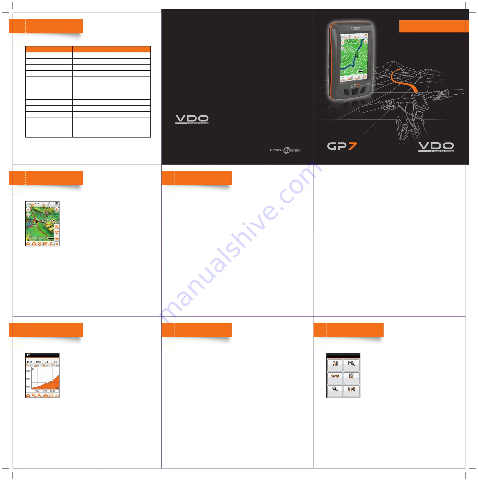
Once chosen the profi le, go outside and wait for the device
to receive the GPS signal and show the location on the map.
It may take up to 15-20 seconds.
When the GPS receives the signal, the device shows the
position with a green arrow on the map. Now the bike trip
can start! The green arrow will follow the changing of the
position on the map.
Press
REC
placed in the upper left part of the map to start
the track recording. Using the same key will stop the recording.
VDO bike navigator powered by MyNav also calculates the route; enter the starting
point and the target:
Main Menu -> Route Planning
STREET:
Odometer
Moving time
Speed
Speed max
Speed avg
ELEVATION:
Ascent/descent
Inclination
Inclination avg ascent/descent
Height, height max, height min
Speed ascent/descent
FITNESS:
HR, max, avg
Pulsation % of FC max
Pulse time (HR sensor)
Cadence, cadence max, avg
Calories
GPS:
Direction, track direction
Ascent to destination/waypoint
Descent to destination/waypoint
Distance to destination/waypoint
Time to destination/waypoint
Arrival time at destination/waypoint
Coordinates
OTHER:
Battery
Date
Time
Besides map position, while running, it is possible to view also the trip computer data.
Use the device key (C) to visualize the trip computer.
The trip computer is composed by a series of screens which appear alternatively by
simply touching the device display.
The data
(1)
available are:
Use “
Function
” to choose to see actual, total or lap values.
With “
Reset
” the data will be deleted from the Trip Computer and stored in History
Trip.
From
Settings -> Advanced -> Trip Computer -> Interface Layout
, it possible to
choose how many values display in every Trip Computer screen. From the same menu
choose “
Confi gure
”, to select which values have to be shown in each data fi eld and
on the map.
HISTORY:
VDO bike navigator powered by MyNav, keeps memory of the trip data in the history.
From
My Menù -> History Trip
,
Logbook
or
Total.
Thoroughly, the Logbook enables to register the trip computer data (actual and lap)
and store them in a single fi le. The archive fi les are automatically generated at each
Reset of “
Actual values
” and “
Lap
”.
Every Reset in the “
Total values
” window will automatically generate a new archive
fi le, which can be seen in “
Total
”.
VIEW TRIP DATA:
10
TRIP COMPUTER
(1)
The values visualizable may vary according to the settings chosen by the user.
After a route has been planned (Point 9), an elevation profi le
of the current route can be displayed (distance/height).
In navigation, the shifting of the position on the map is
alligned to the shifting of the position on the elevation
profi le graph.
The double view “map + elevations”, which enables to
see in the same screen both the elevations graph and the
position on the map can be displayed.
The profi le can be viewed thanks to zoom and pan functions: select a point on the
graph to get distance, height and inclination data.
With a simple touch it is possibile to switch from a point on the map to a point on the
graph or to maintain both the visualizations.
NAVIGATE WITH ELEVATIONS:
11
ELEVATIONS
From
Main Menu -> Profi les -> Personal data
set personal data (gender, age, weight and HR max).
Enter
My Menu -> Training,
please choose between a
FREE TRAINING
or to compete on a
TRACK RACE.
FREE TRAINING
The free training can be carried out setting targets according to:
•
HR
(zone, target)
•
CALORIES
(kcal burning, target)
•
TIME
(time min, target)
•
DISTANCE
(distance km, target)
TRACK RACE
A track recorded as at Point 9, can be saved and loaded second time to challenge with
Track Race, from “
Load
”.
Track Race
is a competiton on a track previuosly done, VDO bike navigator show
positive/negative values, comparing actual GPS data with the ones of the track pre-
voiusly recorded, showing on the map the position of the target with a red point.
TRAINING FUNCTIONALITIES AND TRACK RACE:
12
TRAINING
The Main Menu enables to manage all the different
functionalities of the program. For more information please
read carefully the complete user guide, here a quick
overview:
MAP:
map viewing.The map can be queried simply touching
it to get a lot of useful information.
FIND DESTINATION
and start navigation towards: addresses,
POIs, Geo Notes, coordinates, recent destinations, favourites,
outdoor elements, etc.
ROUTE PLANNING
, to plan a route entering waypoints and choosing how to connect
them, delete and edit a route previously set.
MY MENU
, personal data recording and management: Points (Geo Notes) and tracks
stored by the user, points collected among favourites or saved routes, trip, history
and training data.
SETTINGS
, main software settings: map customization, (view and menu), route
planning type and mode, system settings and advanced confi gurations.
PROFILES
, to manage the different profi les and to calculate the max HR entering
personal data.
OTHER FUNCTIONS:
13
MAIN MENU
QUICK START GUIDE
English