19-20
19 TOP FIELD MODE
19.5.2To Delete Coordinate Data
6
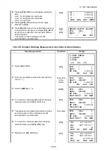
Enter the horizontal distance (OFFSET) from
"END" point.
To select directions, press
{F1}
(LEFT) to move to
the left and
{F2}
(RIGHT) to the right.
Enter
OFFSET,
{F1}
or
{F2}
7
Set with
{ENT}
key.
The conditions for calculating coordinate data will
be displayed.
{ENT}
8
Press
{F1}
(OK) to calculate coordinate data.
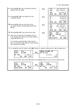
After the coordinate data is calculated, the
procedure will move onto coordinate point/
description entries.
The procedures below will be the same as the
ones for entering coordinates directly
(COORDINATE).
{F1}
Enter PT#,
Enter
DESC
The calculated value will be displayed for the
coordinate data. Set with
{ENT}
key.
{ENT}
{ENT}
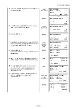
Operating procedure
Operation
Display
1
Select
{F2}
(DELETE POINT).
{F2}
2
Select the type of data to delete.
{F1}
(DESIGN PT)
••••••
Coordinate data entered directly and
recorded for addition of coordinates
{F2}
(MEASUREMENT PT)
••••••
Coordinate data observed and recorded
through layout, TOPO, etc.
{F1}
or
{F2}
ENTER FROM END PT#
R = 5.000_ m
LEFT RIGHT CLR
START [P01 ]
END [P02 ]
R : 5.000 m
OK EDIT
↓
ENTER NEW POINT:
PT#: [_ ]
DESC: [ ]
ALP CLR
ENTER NEW POINT:
PT#: [P03 ]
DESC: [POINT_ ]
ALP CLR
N [ 10.000 ]
E [ 5.000 ]
Z [ 0.000 ]
ENTER
PT#: [P03 ]
STORED!
JOB [JOB1 ]
1.COORDINATES
2.REFLINE
3.TAPE
[1] [2] [3]
1.ADD POINT
2.DELETE POINT
3.VIEW POINT
[1] [2] [3]
↓
1.DESIGN PT
2.MEASUREMENT PT
[1] [2]
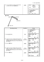
ENTER PT TO DEL
PT#: [_ ]
DESC: [ ]
↑
↓
ALP CLR


