background image

Black plate (68,1)

Connecting the system

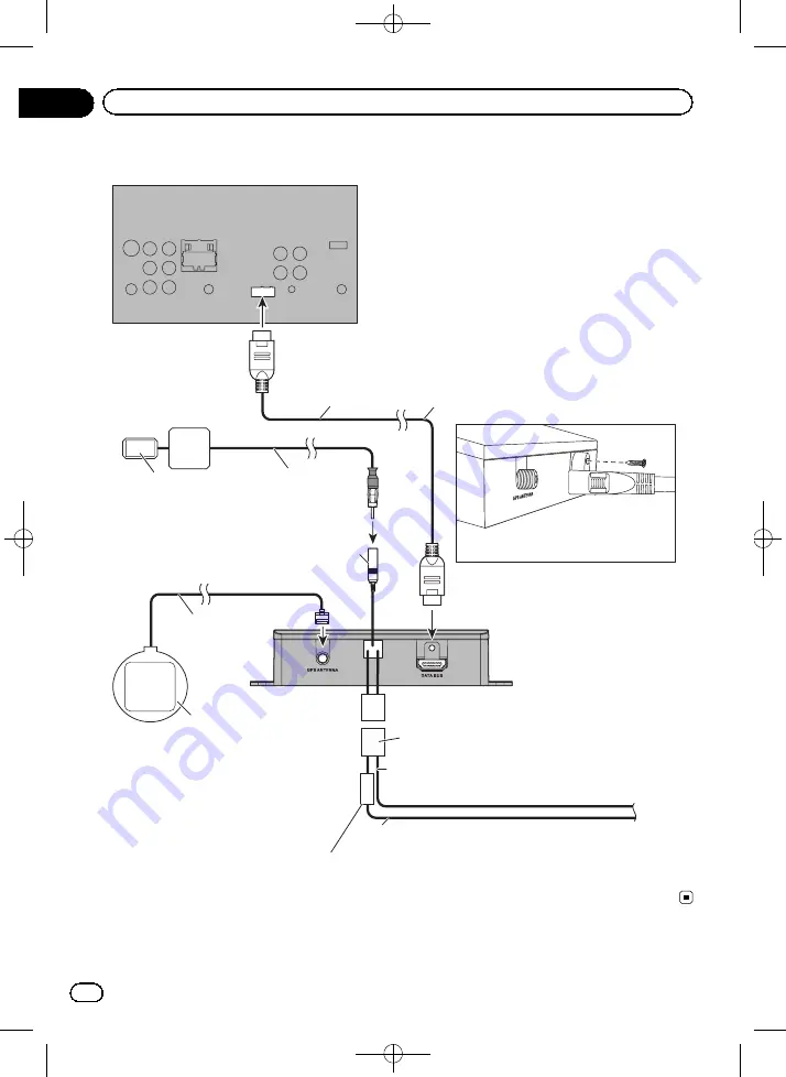
FUSE

Secure the RGB cable with 
the 11 mm (.4 in) screw

The navigation unit

Where applicable, secure the cable to 
the AV receiver using an 11 mm (.4 in) 
screw (supplied).

Insert one end of the RGB cable into the “DATA BUS” 
slot on the side of this product and secure it with an 
11 mm (.4 in) screw (supplied). Connect the other 
end of the cable to RGB IN input on the back of your 
Pioneer AV receiver.

TMC aerial (supplied)

Attach the GPS aerial to 
the “GPS ANTENNA” jack 
on the side of this product.

GPS aerial (supplied)

TMC aerial IF

AV receiver

RGB cable (supplied)

Yellow (B+)

To the terminal that the power is always supplied 
regardless of the ignition switch position.

Black (GND)

To vehicle (metal) body.

Power cord (supplied)

Fuse (3 A, 250 V)

Affix the double-sided tape (supplied) 
on the surface as level as possible 
where the GPS aerial faces the 
window. Place the GPS aerial on the 
double-sided tape.

2.65 m

3 m

2 m

<127075024473>68

Engb

68

Chapter

13

Installation

Содержание AVIC-F130

Страница 1: ...k plate 1 1 Owner s Manual HIDE AWAY NAVIGATION SYSTEM FOR TRUCKS CAMPER VANS AVIC F130 HIDE AWAY NAVIGATION SYSTEM AVIC F250 For details on software updates visit www naviextras com English 127075024473 1 ...

Страница 2: ...Black plate 2 1 127075024473 2 Engb 2 ...

Страница 3: ...nctions 15 Inserting an SD memory card 15 Resetting the microprocessor 16 Before you start On first time startup 17 Regular startup 18 How to use the navigation menu screens Screen switching overview 19 What you can do on each menu 20 Operating list screens e g route settings screen 20 Operating the on screen keyboard 20 Monitoring the GPS reception quality 21 How to use the map How to read the ma...

Страница 4: ...t waypoints 46 Setting driving time alerts 47 Modifying the route 48 Selecting a new destination when already having a route 48 Setting a new starting position for the route 48 Editing the list of destinations 49 Cancelling the current route guidance 49 Checking route alternatives for the current route 50 Watching the simulation of the route 50 Navigating in off road mode 51 Registering and editin...

Страница 5: ... system 68 Installing with the hook and loop fastener 69 Appendix Positioning technology 70 Positioning by GPS 70 Handling large errors 70 When positioning by GPS is impossible 70 Conditions likely to cause noticeable positioning errors 70 Route setting information 72 Route search specifications 72 SD and SDHC logo 73 Display information 74 Glossary 74 Specifications 75 127075024473 5 Engb 5 Conte...

Страница 6: ...slation that re quires proper treatment recovery and recy cling Private households in the member states of the EU in Switzerland and Norway may return their used electronic products free of charge to designated collection facilities or to a retai ler if you purchase a similar new one For countries not mentioned above please con tact your local authorities for the correct meth od of disposal By doi...

Страница 7: ...ny other means You shall not use the Software to operate a service bureau or for any other use involving the processing of data for other per sons or entities Pioneer and its licensor s shall retain all copy right trade secret patent and other proprie tary ownership rights in the Software The Software is copyrighted and may not be cop ied even if modified or merged with other pro ducts You shall n...

Страница 8: ...on of this warranty is prohibited by any country or local law which cannot be pre empted 4 EXPORT LAW ASSURANCES You agree and certify that neither the Software nor any other technical data received from Pioneer nor the direct product thereof will be exported outside the country or district the Country governed by the government having jurisdiction over you the Government ex cept as authorised and...

Страница 9: ...Black plate 9 1 END USER LICENSE AGREEMENT 127075024473 9 Engb 9 Chapter 02 Introduction Introduction ...

Страница 10: ...Black plate 10 1 127075024473 10 Engb 10 Chapter 02 Introduction ...

Страница 11: ...Do not attempt to install or service your navi gation system by yourself Installation or servi cing of the navigation system by persons without training and experience in electronic equipment and automotive accessories may be dangerous and could expose you to the risk of electric shock or other hazards If liquid or foreign matter should get inside this navigation system park your vehicle to safe p...

Страница 12: ...f your navigation system Do not operate this navigation system or the rear view camera option if purchased if doing so will divert your attention in any way from the safe operation of your vehicle Always observe safe driving rules and fol low all existing traffic regulations If you ex perience difficulty in operating the system or reading the display park your vehicle in a safe location and apply ...

Страница 13: ...proaching a restricted road segment or such roads must be used in your route Warnings are both visual and audible There are different kinds of warnings When approaching a restricted road segment without a route you are warned that there is a restricted area ahead Restricted road segments are excluded from your routes but in some cases some restricted roads need to be used to reach the given destin...

Страница 14: ...m fail to operate properly contact your dealer or nearest authorised Pioneer Service Station Visit our website Visit us at the following site http www pioneer eu Register your product We will keep the de tails of your purchase on file to help you refer to this information in the event of an insurance claim such as loss or theft We offer the latest information about PIONEER CORPORATION on our websi...

Страница 15: ...t to the left WQVGA video is output When the switch is set to the right WVGA video is output 3 Reset button For details refer to Resetting the micro processor on the next page 4 Power indicator Inserting an SD memory card p The included SD memory card must be in serted into the SD card slot for prior to using the AVIC F130 or AVIC F250 for the first time 1 Insert an SD memory card into the SD card...

Страница 16: ...uct fails to operate properly If there appear to be problems with the op eration of the system When changing the combination of equip ment When adding removing additional pro ducts that connect to the navigation sys tem If your vehicle position is shown on the map with a significant positioning error Press the reset button on this product with a pointed object such as the tip of a pen Reset button...

Страница 17: ...one p Later you can change it in Regional set tings For details refer to Customising the regional settings on page 62 The navigation system will restart and the End User Licence Agreement screen is dis played 5 Read the disclaimer carefully checking its details and then touch Accept if you agree to the conditions The configuration wizard starts 6 Touch Next to continue 7 Select the language that y...

Страница 18: ...ch Finish The initial setup is now complete After touching Finish the Navigation Menu screen appears and you can start using the navigation system Regular startup 1 Start the engine to boot up the system 2 Press the MODE button of the AV recei ver After a short pause the navigation screen ap pears p The display will turn off if you press the MODE button of the AV receiver immedi ately after the na...

Страница 19: ...switching overview Navigation screen Press the MODE button of the AV receiver AV receiver screen e g AVH P4300DVD 127075024473 19 Engb 19 Chapter 04 How to use the navigation menu screens How to use the navigation menu screens ...

Страница 20: ...n 5 My Route menu You can display your route information on the map You can also perform route related ac tions such as editing or cancelling your route on this menu 6 More menu You can customise the way the navigation sys tem works to simulate demo routes or to run some additional applications 7 Traffic summary screen You can check the summary of traffic events on the set route Operating list scr...

Страница 21: ...ng appear in a list after entering a couple of characters to open the list of results before it appears automati cally touch Results 6 Touch to switch to a keyboard offering nu meric and symbol characters 7 Touch to correct your entry on the keyboard Touching and holding deletes several char acters or the entire input string 8 Touch to finalise the keyboard entry accept the suggested search result...

Страница 22: ... shows the type of the second next manoeuvre if it is near the first one For details refer to Frequently shown route events on the next page 3 Distance to the next guidance point man oeuvre Shows the distance to the next manoeuvre 4 Second manoeuvre arrow Shows the turning direction after next gui dance point and the distance to there 5 Current position Indicates the current location of your vehic...

Страница 23: ... into account in the route calculation b Quick menu Touching this key causes the quick menu to appear For details refer to Quick menu on page 20 Frequently shown route events Icon Description Turn left Turn right Turn back Bear right Turn sharp left Icon Description Keep left Continue straight in the intersec tion Go left on the roundabout 3rd exit next manoeuvre Enter roundabout second next manoe...

Страница 24: ...rch for useful Points Of Interest POI nearby on the screen Follow the steps below to open the Where Am I screen 1 Display the map screen For details of the operations refer to Screen switching overview on page 19 2 If the current street is displayed below the arrow mark current position touch it to open the Where Am I screen Touch in the top right corner of the screen to open the quick menu screen...

Страница 25: ...antee arrival at that time For details refer to Setting the vehicle parameters on page 43 p You can change the value by touching and holding any of the fields Display during motorway driving In certain locations of the motorway lane in formation is available indicating the recom mended lane to be in to easily manoeuvre the next guidance Lane information While driving on the motorway motorway exit ...

Страница 26: ...l keys appear 3 Touch or to change the map scale p Map scaling has a limit in 3D map view mode If you zoom out further the map switches to 2D view mode For details refer to Switching the map be tween 2D and 3D on the next page 4 Touch Back to move the map back to follow the current GPS position Smart Zoom Your navigation system features Smart Zoom that works in two ways When the route is set When ...

Страница 27: ... switching overview on page 19 2 Touch anywhere on the map during na vigation The map stops following the current position and control keys appear 3 Touch to tilt up down or to rotate left right p Touching the key once modifies the view in large steps and touching and holding the key modifies it continuously and smoothly 4 Touch Back to move the map back to follow the current GPS position Switchin...

Страница 28: ...ack to follow the current GPS position Viewing information about a specified location An icon appears at registered places such as Favourites entries and places where there is a POI icon or traffic information icon Place the cursor over the icon to view detailed infor mation 1 Scroll the map and move the scroll cur sor to the icon you want to view 2 Touch to see the details of the se lected locati...

Страница 29: ...f the operations refer to Screen switching overview on page 19 2 Touch Find then Find Address 3 Touch Country enter the first few let ters of the country on the keyboard and then select one country from the list of re sults By default your navigation system proposes the country and city town where you are If no changes are required skip steps 3 and 4 4 Touch Town and enter the name of the city tow...

Страница 30: ...ntre 1 Touch Menu on the map screen The Navigation Menu screen appears For details of the operations refer to Screen switching overview on page 19 2 Touch Find then Find Address 3 If necessary modify the country For details of the operations refer to Search ing for a location by address on the previous page 4 Touch Town and enter the name of the city town on the keyboard 5 Touch Select Town The ma...

Страница 31: ...earching for Points of Interest POI Information of various facilities Points Of In terest POI such as petrol stations car parks or restaurants is available You can search for a POI by using the Quick Search feature or by selecting the category or entering the POI name Searching for POIs using Quick Search You can quickly find a favourite place by its name The search is always carried out along the...

Страница 32: ... The preset search categories are as follows Petrol Station Along Route When the route is set petrol stations are searched along the route When the route is not set they are searched around the current position When the current position is not avail able either no GPS signal they are searched around the last known posi tion Parking At My Destination When the route is set car parks are searched alo...

Страница 33: ...position or if it is not available around the last known posi tion The result list will be ordered by the distance from this position Around Destination Searches for a place around the destination of the current route The result list will be ordered by the distance from the destina tion Along Route Searches along the current route and not around a given point This is useful when you search for a l...

Страница 34: ... directly from the name of the facilities You can search for POIs by their names 1 Touch Menu on the map screen The Navigation Menu screen appears For details of the operations refer to Screen switching overview on page 19 2 Touch Find then Find Places 3 Touch Custom Search 4 Select the area around which the POIs should be searched for In a Town Searches for a place within a selected city town The...

Страница 35: ...y 7 Touch Find by Name if you have not done it before 8 Using the keyboard start entering the name of the place 9 After entering a few letters touch Re sults The screen appears showing the list of places with names containing the entered character sequence 10 Touch the POI you want The searched location appears on the map screen For the subsequent operations refer to Set ting a route to your desti...

Страница 36: ...h Find on Map 4 Move and scale the map to locate your destination 5 Touch Select The selected location appears on the map screen For details refer to Setting a route to your destination on page 39 p You can also select a map location as the destination by scrolling the map For details refer to Searching for a location by scrolling the map on page 38 For details refer to Modifying the route cal cul...

Страница 37: ...d on the Navigation Menu screen 3 Touch or in the History field The searched location appears on the map screen For the subsequent operations refer to Set ting a route to your destination on page 39 History Three most likely destinations are displayed on the first page of the list while the rest of the destinations are ordered by time they were last selected 1 Touch Menu on the map screen The Navi...

Страница 38: ...route to your destination on the next page Searching for a location by scrolling the map Specifying a location after scrolling the map enables you to set the position as destination waypoint 1 Display the map screen For details of the operations refer to Screen switching overview on page 19 2 Touch and drag the screen to scroll the map to the position you want 3 Touch the location that you want to...

Страница 39: ... already having a route on page 48 3 Touch Go Your navigation system starts the route gui dance Touch More to modify route parameters Checking route alternatives when planning the route You can select from different route alternatives or change the route planning method after you have selected a new destination 1 Search for a location For details refer to Searching for and select ing a location on...

Страница 40: ... overview on page 19 2 Touch My Route on the Navigation Menu screen 3 Touch Create Route p The start point of the route normally it is the current GPS position is displayed 4 Touch p When the Create Route option is not dis played touch More to open a list with more options 5 Select the destination you want to set You can select the destination of the route the same way as described in the previous...

Страница 41: ...ted p If you have already set the route to the desti nation Next will appears Touch Next and select the way to modify the current route For details refer to Selecting a new destina tion when already having a route on page 48 7 Touch Go Your navigation system starts the route guidance 127075024473 41 Engb 41 Chapter 07 After the location is decided After the location is decided ...

Страница 42: ... g Fast 7 Estimated delay calculated from traffic events on your route p The following options are available For details refer to Registering and editing locations on page 52 Edit Route Touch this key to add or remove destina tions or change their sequence You can also set a route start point other than your current location This can be useful to plan and save a future map Overview Touch this key ...

Страница 43: ...rictions and directional con straints are taken into account when plan ning a route Roads are used only if access for taxis is al lowed Private roads resident only roads and walk ways are excluded from routes Default Lorry Manoeuvre restrictions and directional con straints are taken into account when plan ning a route Roads are used only if access for lorries is allowed Private roads resident onl...

Страница 44: ...e Height Set the height of the vehicle Trailer Set if there is a trailer attached to the ve hicle Maximum Allowed Weight Set the maximum allowed weight of the vehicle Actual Weight Set the actual weight of the vehicle Freight Select one or more hazard types if the vehicle carries dangerous material You can also set the following option Confirm Parameters for Each Route Plan ning When enabled the l...

Страница 45: ...gardless of the speed this route type is rarely practical for normal vehicles Economical For vehicle types where Green routing is not available this method combines the benefits of Fast and Short This system calculates as if it were calculat ing the Fast route but it takes other roads as well to save fuel p This item is available for AVIC F130 only Easy Results in a route with fewer turns and no d...

Страница 46: ... The navigation system excludes unpaved roads by default Calculate Green Alternative If the selected routing method is not Green you can have your route compared to the best green alternative on the screen when confirming the route If this alterna tive is much better than the selected meth od you can quickly switch to Green mode 5 Touch Back to confirm the changes The navigation system recalculate...

Страница 47: ...an select 2 Drivers to use the vehicle with two drivers The timer defaults are the same but the timers will count down for each driver individually 6 When finished touch and hold Back The map screen returns Whenever the vehicle stops the current driver receives a message a few minutes later whether this stop means a break When a break is initiated the continuous driv ing timer stops and it is rese...

Страница 48: ...e where a waypoint to appear use the Edit Route menu Final Destination Touch this key to append the newly se lected destination at the end of the route The other destinations of the route remain intact The previous final destination is now the last waypoint Setting a new starting position for the route For normal navigation all routes are planned from the current position In order to check fu ture...

Страница 49: ... or reorder the list 1 Touch Menu on the map screen The Navigation Menu screen appears For details of the operations refer to Screen switching overview on page 19 2 Touch My Route on the Navigation Menu screen 3 Touch Edit Route when you already have a route Touch this key to add a new destination Touch this key to delete a destination Touch this key to modify the start point of the route More Tou...

Страница 50: ...For details of the operations refer to Screen switching overview on page 19 2 Touch My Route on the Navigation Menu screen 3 Touch More 4 Touch Route Alternatives 5 Touch any of the alternatives to see it on the map If you cannot find a good alternative touch More Results and scroll down for routes with different routing methods 6 Select one of the alternatives and touch Back The map screen return...

Страница 51: ... simulation Jumps to the next guidance point man oeuvre Increases the speed of the simulation to four eight or 16 times faster Touching the key again returns to the normal speed Touch Back The simulation stops Navigating in off road mode You can switch your navigation to off road mode The off road mode navigates between destinations in a straight line regardless of the road network and traffic reg...

Страница 52: ... download more from our website or save any map location as an alert point a speed camera or a railway crossing for example p This feature can warn you when you ap proach one of these points The following alert types are available Audio and Visual A sound beeps or announces the type of the alert Visual The type of the alert point its distance and the related speed limit ap pear on the map For deta...

Страница 53: ...r a railway crossing for exam ple 1 Scroll the map and select the alert point to edit The cursor appears around the alert point 2 Touch More 3 Scroll down the list and touch Edit Alert Point 4 Modify the necessary parameters Type of Alert Modify the type of alert point Direction of Alert Modify the direction from which you expect the alert Speed Limit Modify the speed limit for this alert point if...

Страница 54: ...raffic jams Receiving real time traffic information TMC Traffic Message Channel TMC can provide you with the real time status of the traffic Your device contains the TMC receiver that is needed to receive traffic incidents the receiver is enabled by default If you need to enable the TMC receiver follow the steps below 1 Touch Menu on the map screen The Navigation Menu screen appears For details of...

Страница 55: ... on the map and small symbols above the road show the nature of the incident p A special icon appears to show you whether traffic incidents are received The icon shows the status of the traffic receiver when there are no traffic incidents on your route otherwise it shows the type of the next traffic incident on your route 1 Touch 2 Touch Event List The list of traffic incidents appears 3 Touch any...

Страница 56: ...een These controls affect key sounds Voice Language Displays the current voice guidance profile If you touch this key you can select a new profile from the list of available languages and speakers Touch any of these to hear a sample voice prompt Just touch Back when you have selected the new spoken language Different voice profiles are capable of differ ent levels of service Natural Voice These pr...

Страница 57: ... the related speed limit appear on the map screen while you are ap proaching one of these cameras For some of the alert points the enforced or expected speed limit is available For these points the audio alert can be different if you are below or above the given speed limit When approaching The audio alert is always played when approaching one of these alert points In order to draw your attention ...

Страница 58: ...S Info Displays the GPS information screen with satellite position and signal strength infor mation Configure Driving Timers Displays the screen for setting the driving timers p This item is available for AVIC F130 only Setting the traffic information The recommended route is not always the same between two points Whenever suitable data exists traffic information can be taken into account in the r...

Страница 59: ...operations refer to Dis playing the settings screen on page 56 2 Touch Map Settings The Map Settings screen appears 3 Touch the setting item You can see the effect when you change a set ting View Mode Switch the map view between a 3D perspec tive view and a 2D topdown view Viewpoint Adjust the basic zoom and tilt levels to your needs Three levels are available Automatic Overview When selected the ...

Страница 60: ...screen on page 56 2 Touch Visual Guidance Settings 3 Touch the setting item Data Fields The data fields in the corner of the map screen can be customised Touch this key and select the values you want to see The values can be different when you navigate a route from when you are just cruising with out a given destination You can select gen eral trip data like your current speed or the altitude or r...

Страница 61: ... Turn to the suggested new direction and the route will be automatically recalcu lated Offer Real time Route Alternatives Alternative routes can be suggested when driving on normal roads This system will select a different turn in the upcoming in tersection and offers you a different route for the next section of the route But you cannot modify the offered detour Offer Parking Around Destination P...

Страница 62: ...tain useful information about your trips Trip logs can be saved manually when you reach your destination or you can turn on the automatic saving here You can ac cess these logs in the Trip Monitor Trip Monitor is available from the More menu 1 Display the settings screen For details of the operations refer to Dis playing the settings screen on page 56 2 Touch Trip Monitor 3 Touch More then touch T...

Страница 63: ... details refer to Customising the regional settings on the previous page 5 If needed modify the default route planning options then touch Next p Later you can change them in Route Set tings For details refer to Setting the route calcula tion on page 45 Resetting to the default settings Delete all saved data and reset all settings to their factory defaults 1 Display the settings screen For details ...

Страница 64: ...regular car mainte nance Sunrise Sunset Touch this key to see the sunlit and dark areas of the world Your current location and route points are marked on the map Touch Details to see the exact sunrise and sunset times for all your route points your current location all waypoints and the final destination Trip Monitor If you save your trip logs when you arrive at some of your destinations or let th...

Страница 65: ...onnected to the battery engine vibration may eventually cause the insulation to fail at the point where the wire passes from the passenger com partment into the engine compartment If the yellow lead s insulation tears as a re sult of contact with metal parts short cir cuiting can occur resulting in considerable danger It is extremely dangerous to allow cables to become wound around the steering co...

Страница 66: ...ause a fire and or damage the products if their earths became detached When replacing the fuse be sure to only use a fuse of the rating prescribed on this product When disconnecting a connector pull the connector itself Do not pull the lead as you may pull it out of the connector This product cannot be installed in a vehi cle without ACC accessory position on the ignition switch ACC O N S T A R T ...

Страница 67: ...mpatibility checked by your dealer If parts other than supplied or compatible ones are used they may damage internal parts of this product or they may work loose and the product may become de tached It is extremely dangerous to allow cables to become wound around the steering col umn or gearstick Be sure to install this product its cables and wiring away in such so that they will not obstruct or h...

Страница 68: ... the back of your Pioneer AV receiver TMC aerial supplied Attach the GPS aerial to the GPS ANTENNA jack on the side of this product GPS aerial supplied TMC aerial IF AV receiver RGB cable supplied Yellow B To the terminal that the power is always supplied regardless of the ignition switch position Black GND To vehicle metal body Power cord supplied Fuse 3 A 250 V Affix the double sided tape suppli...

Страница 69: ...t and attach the hook and loop fastener Navigation unit Protective sheet 3 Decide on the installation position 4 Peel off the other protective sheet and install the navigation unit on the surface of the glove box or similar location Navigation unit Protective sheet Surface of the glove box or similar location 127075024473 69 Engb 69 Chapter 13 Installation Installation ...

Страница 70: ... if signals can not be received from more than two GPS satellites In some driving conditions signals from GPS satellites may not reach your vehicle In this case it is impossible for the system to use GPS positioning In tunnels or en closed parking garages Under elevated roads or similar structures When driving among high build ings When driving through a dense forest or tall trees If a car phone o...

Страница 71: ...e a recently opened road that is not on the map If you drive in zigzags If the road has a series of hairpin bends If there is a loop or similar road configura tion If you take a ferry If you are driving on a long straight road or a gently curving road If you are on a steep mountain road with many height changes 127075024473 71 Engb 71 Appendix Appendix Appendix ...

Страница 72: ...route and voice guidance for the route are automatically set Also for day or time traffic regulations only infor mation about traffic regulations applicable at the time when the route was calculated is consid ered One way streets and street closures may not be taken into consideration For example if a street is open during the morning only but you arrive later it would be against the traffic regul...

Страница 73: ...y route calculation again When there is a traffic jam ahead a detour route may not be suggested if driving through the traffic jam would still be better than taking the detour There may be instances when the starting point the waypoint and the destination point are not on the highlighted route The number of roundabout exits displayed on the screen may differ from the actual number of roads Route h...

Страница 74: ...Clothing Calculator Fuel Consumption Sunrise Sunset Trip Monitor Country Information Help Glossary Current location The present location of your vehicle your cur rent location is shown on the map by a blue triangle mark default Destination A location you choose as the end point of your journey Favourites A frequently visited location such as your workplace or a relative s home that you can registe...

Страница 75: ...a track log It is handy when you want to check a route travelled or if returning along a complex route Voice guidance The giving of directions by navigation voice while in guidance Waypoint A location that you choose to visit before your destination a journey can be built up from multiple waypoints and the destination Specifications General Rated power source 14 4 V DC allowable voltage range 12 0...

Страница 76: ...NEER EUROPE NV Haven 1087 Keetberglaan 1 B 9120 Melsele Belgium Belgique TEL 0 3 570 05 11 PIONEER ELECTRONICS USA INC P O Box 1540 Long Beach California 90801 1540 U S A TEL 800 421 1404 2012 2013 PIONEER CORPORATION All rights reserved Printed in China 127075024473 EU EW KMZZX 13B00000 127075024473 76 ...

Отзывы: