


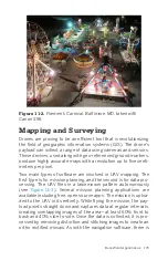


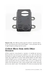


Figure 11-2.
Firemen’s Carnival, Baltimore, MD, taken with
Canon S95.
Mapping and Surveying
Drones are proving to be an efficient tool that is revolutionizing
the field of geographic information systems (GIS). The drone’s
payload can collect a range of data using cameras and sensors.
These devices, used along with geo-referenced ground markers,
produce highly accurate maps with a resolution up to five centi-
meters per pixel.
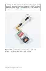
Two main types of software are involved in UAV mapping. The
first type is for mission planning, and the second is for data pro-
cessing. The UAV flies in a lawnmower pattern autonomously
(see
). Several mission planning applications are
available including free, open source apps. The mission is uploa-
ded to the UAV in its entirety. While flying the mission, the pay-
load points straight down and captures data at regular intervals,
creating overlapping images of the area—at least 60% front to
back and 40% side to side. Once the data is collected, it is pro-
cessed by removing distortion and stitching images to create an
ortho rectified mosaic. As with the navigation software, there is
Real-World Applications 173
Содержание Belinda Kilby
Страница 1: ......
Страница 3: ...Make Getting Started with Drones Terry Kilby and Belinda Kilby...
Страница 25: ...Figure 1 5 Basic quadcopter showing how the stick commands would move the craft Introduction 13...
Страница 26: ......
Страница 90: ......
Страница 126: ......
Страница 142: ...Figure 8 7 Mobius camera next to the quick release camera mount 130 Make Getting Started with Drones...
Страница 146: ...Figure 9 4 Firmware upload has begun Figure 9 5 Firmware verification in progress 134 Make Getting Started with Drones...
Страница 153: ...Figure 9 10 Compass setup Figure 9 11 Compass calibration ArduPilot Mega APM Setup 141...
Страница 198: ......


