


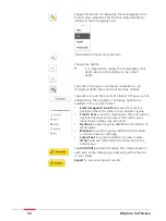


Allows adding points of interest of the area while still on
site. Following options are available in the current POI
list:
•
Electromagnetic Location
is used to mark the
positions where the cable locator detects signals.
•
Trench Scar
is used to mark where the road surface
has been opened and covered. This option gives
ideas where utilities may be buried.
•
Hydrant
is used for giving additional information on
water pipes.
•
Manhole
is used for giving additional information
on water, sewer or drainage.
•
Lamp Post
is a great indication of power cables.
•
Other
: Add POIs which do not belong to the listed
types.
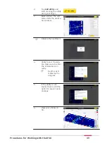
Once the data acquisition is completed, tap
Analyse
Data
to process the scan data. The result is displayed
and by default in animation in the next screen.
4.4
Data Processing
Tap the button
Analyse Data
on the top right of the acquisition screen to
open the processing/tomography screen. This button is greyed out when
data acquisition has not been completed. It turns yellow once the acquisi-
tion is completed.
Data processing
screen
30
DXplore Software
Содержание DSX
Страница 1: ...Leica DSX User Manual Version 1 1 English ...
Страница 51: ...6 The Home screen appears with the GNSS icon in green Procedures for Working with the DSX 51 ...
Страница 53: ...Wet connectors must be dry before attaching the dust cap Connectors with dust caps Care and Transport 53 ...
Страница 57: ......


