


Section 8 Terrain Awareness Warning System
1
st
Ed Nov 2018
IDU-450 EFIS Software Version 8.0H (Rotorcraft)
8-15
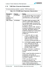
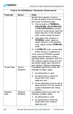
8.10. TAWS Basic Parameter Determination
The fundamental parameters used for TAWS functions are.
Table 8-12: HTAWS Basic Parameters Determination
Parameter Source
Notes
Aircraft
position,
groundspeed
and track
GPS/SBAS
HFOM must be less than or equal to
the greater of 0.3 NM or horizontal
alert limit (HAL) for mode of flight.
MSL Altitude
GPS/SBAS
Geodetic height converted to MSL
with the current EGM database. To
be considered valid for use as MSL
altitude, the VFOM must be less than
or equal to 106 feet.
Secondary source of MSL altitude is
barometric altitude from an air data
computer. Barometric altitude is
determined based upon a barometric
setting in the following order of
preference:
1) If either the pilot or co-pilot
system is operating in QNH
mode, the QNH barometric
setting is used (i.e. on-side
barometric setting preferred); or
2) If
GPS/SBAS
geodetic height has
been valid within the last 30
minutes, a barometric setting
derived from the GPS/SBAS
geodetic height is used.
If neither of the above conditions is
met, MSL altitude is marked as
invalid.
When a reporting station elevation is
determined and outside air
temperature is valid, a temperature
correction is applied.
TAWS uses the lower of the
barometric altitude or the
temperature-corrected altitude. In the
case of QNH-mode barometric
setting, reporting station elevation is