


Section 3 Display Symbology
1
st
Ed Nov 2018
IDU-450 EFIS Software Version 8.0H (Rotorcraft)
3-35
2) a hoop or “tethered balloon” (for fly-over waypoints) or “tethered
diamond” (for fly-by waypoints) depicted at the VNAV altitude or at
aircraft altitude (if there is no VNAV altitude), and
3) a line connecting the “X” and the hoop.
The “X” and connecting line are not shown if ground elevation information
is not encoded with the NavData waypoint information (e.g., terminal and
enroute fixes). The active waypoint symbol is drawn using the hidden
surface removal techniques of terrain and obstruction rendering, so an
active waypoint behind terrain appears to be so. The active waypoint
symbol disappears in unusual attitude mode but turns amber (yellow) in the
event of GPS LON caution.
The identifier of the waypoint along with the distance to the waypoint are
displayed in the lower right corner of the PFD in magenta. If a target altitude
is not set and the active waypoint has a VNAV altitude associated as in
Figure 3-55, the identifier includes a display of the VNAV altitude.
NOTE:
Only the active waypoint is shown on the PFD. Subsequent waypoints in
a route are displayed sequentially as the current active waypoint is
passed. With terrain turned off, the active waypoint is always visible
regardless of distance.
If the active waypoint is beyond the lateral limits of the screen, the
magenta waypoint direction pointer (i.e., magenta triangle) on the
directional scale indicates shortest direction of turn to the waypoint.
If the waypoint is only a hoop hanging in space, it is a fix and not directly
associated with a NAVAID on the ground (e.g. VOR, NDB, user waypoint,
or airport).
If the waypoint X disappears behind terrain on the PFD, there is terrain
between the aircraft present position and the waypoint.
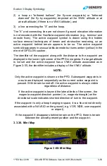
3.3.30. Mini Map
Figure 3-60: Mini Map