background image

Your Route on the Map

NOTICE

The speed limit feature is for information only and does not 

replace your responsibility to abide by all posted speed limit 

signs and to use safe driving judgment at all times. Garmin will 

not be responsible for any traffic fines or citations you receive 

for failing to follow all applicable traffic laws and signs.

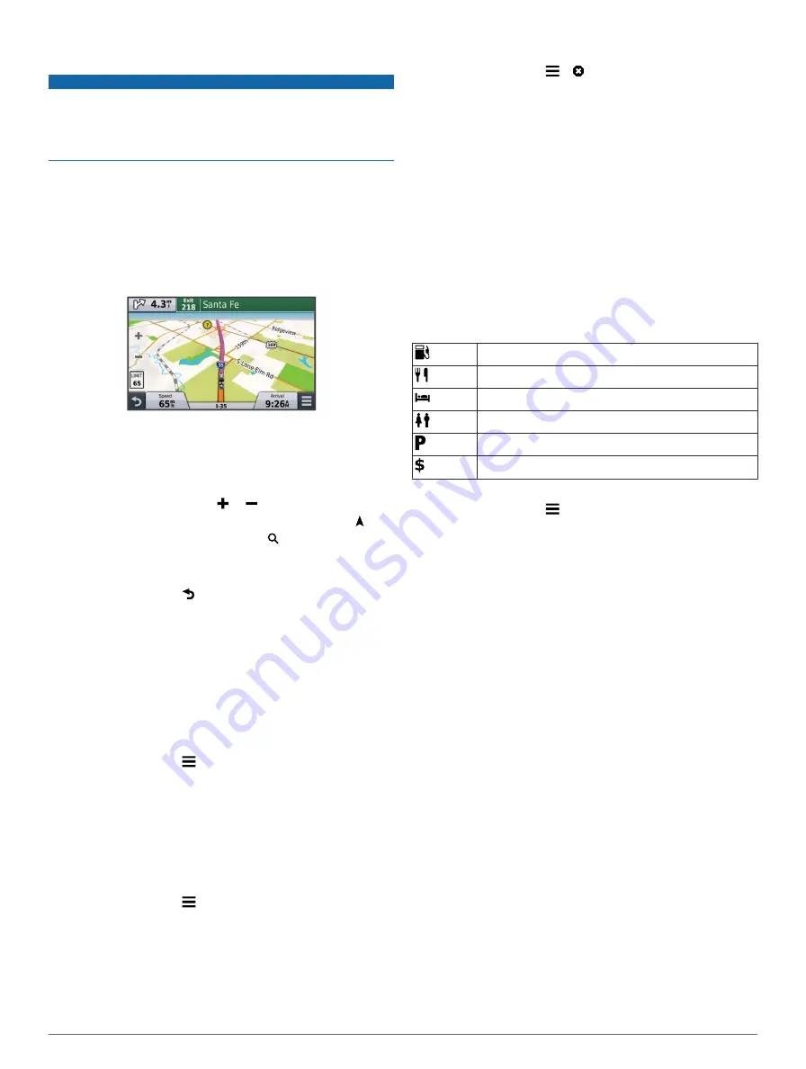
The route is marked with a magenta line. A checkered flag 

marks your destination.
As you travel, the device guides you to the destination with 

voice prompts, arrows on the map, and directions at the top of 

the map. If you depart from the original route, the device 

recalculates the route and provides new directions.
A data field displaying the current speed limit may appear as 

you travel on major roadways.

Using the Map

1

Select 

View Map

.

2

Select anywhere on the map.

3

Select an option:
• To zoom in or out, select   or  .
• To switch between North Up and 3-D views, select  .
• To view specific categories, select  .

Adding a Point to a Route

Before you can add a point, you must be navigating a route.

1

From the map, select   > 

Where To?

.

2

Search for a location.

3

Select a location.

4

Select 

Go!

.

5

Select 

Add to Active Route

.

Skipping a Point in Your Route

If you decide not to go to the next point in your route, you can 

skip the point. This prevents the device from attempting to route 

you back to the missed point. This feature is not available if the 

next point is your final destination.

From the map, select   > 

Change Route

 > 

Skip 

Destination

.

Taking a Detour

Before you can take a detour, you must be navigating a route 

and you must add the change route tool to the map tools menu 

(

Customizing the Map Tools

).

You can take a detour for a specified distance along your route 

or detour around specific roads. This is useful if you encounter 

construction zones, closed roads, or poor road conditions.

1

From the map, select   > 

Change Route

.

2

Select an option:
• To detour your route for a specific distance, select 

Detour 

by Distance

.

• To detour around a specific road on the route, select 

Detour by Road

.

Stopping the Route

From the map, select   >  .

Using Suggested Routes

Before you can use this feature, you must save at least one 

location and enable the travel history feature (

Device and 

Privacy Settings

).

Using the myTrends™ feature, your device predicts your 

destination based on your travel history, the day of the week, 

and the time of day. After you have driven to a saved location 

several times, the location may appear in the navigation bar on 

the map, along with the estimated time of travel, and traffic 

information.

Select the navigation bar to view a suggested route to the 

location.

About Up Ahead

You can view upcoming businesses and services along your 

route or the road on which you are traveling.
Services are listed under tabs by category.

Gas

Food

Lodging

Restrooms

Parking

Banks and ATMs

Finding Upcoming Points of Interest

1

From the map, select   > 

Up Ahead

.

2

Select a tab.

3

Select a point of interest.

Avoiding Road Features

1

Select 

Settings

 > 

Navigation

 > 

Avoidances

.

2

Select the road features to avoid on your routes, and select 

Save

.

About Custom Avoidances

Custom avoidances allow you to avoid specific areas and 

sections of road. You can enable and disable custom 

avoidances as needed.

Avoiding an Area

1

Select 

Settings

 > 

Navigation

 > 

Custom Avoidances

.

2

If necessary, select 

Add Avoidance

.

3

Select 

Add Avoid Area

.

4

Select the upper-left corner of the area to avoid, and select 

Next

.

5

Select the lower-right corner of the area to avoid, and select 

Next

.

The selected area is shaded on the map.

6

Select 

Done

.

Avoiding a Road

1

Select 

Settings

 > 

Navigation

 > 

Custom Avoidances

.

2

Select 

Add Avoid Road

.

3

Select the starting point of the section of road to avoid, and 

select 

Next

.

4

Select the ending point of the road section, and select 

Next

.

5

Select 

Done

.

Navigation

7

Содержание Zumo 590

Страница 1: ...z mo 590 Owner s Manual May 2014 190 01706 00_0B Printed in Taiwan...

Страница 2: ...ies BaseCamp myGarmin myTrends n Maps Guarantee n Maps Lifetime trafficTrends and VIRB are trademarks of Garmin Ltd or its subsidiaries These trademarks may not be used without the express permission...

Страница 3: ...6 Navigation 6 Starting a Route 6 Changing the Route Calculation Mode 6 Previewing Multiple Routes 6 Starting a Route to a Saved Location 6 Taking a Route Using Curvy Roads 6 Your Route on the Map 7 U...

Страница 4: ...15 Connecting the Device to Your Computer 15 Transferring Data From Your Computer 15 Disconnecting the USB Cable 15 Deleting Files 16 Customizing the Device 16 Map and Vehicle Settings 16 Enabling Map...

Страница 5: ...based on available power sources and safe cable routing Motorcycle cradle Bare wires with inline fuse for power connection to motorcycle power Installing the Handlebar Base The device includes parts f...

Страница 6: ...eat store the device out of direct sunlight Do not use the suction cup mount on a motorcycle See the Important Safety and Product Information guide in the product box for product warnings and other im...

Страница 7: ...r product registration optional 7 Click save device 8 Click check for updates A list of available map and software updates appears 9 Select the updates to install 10Click Install Now The Garmin Expres...

Страница 8: ...the keyboard language mode Select to enter special characters such as punctuation marks Select to change character capitalization About Shortcuts Adding a Shortcut You can add shortcuts to the Where T...

Страница 9: ...ct Done 5 Select the longitude coordinate 6 Enter the new coordinate and select Done 7 Select View on Map Finding a Location by Browsing the Map Before you can find places included in the map data suc...

Страница 10: ...ssary install the Garmin Communicator Plugin NOTE Go to www garmin com communicator for more information 3 On your computer find a location on a supported website 4 From the website select Send to GPS...

Страница 11: ...oads or poor road conditions 1 From the map select Change Route 2 Select an option To detour your route for a specific distance select Detour by Distance To detour around a specific road on the route...

Страница 12: ...l stops you must enable Fuel Tracking Enabling Fuel Tracking You can set the device to suggest fuel stops based on your estimated fuel range Select Apps Fuel Settings Dynamic Fuel Stops Map Pages Cust...

Страница 13: ...s can be used for multimedia audio Before you can receive navigation prompts through your headset you must pair your device with a compatible mobile headset 1 Place your headset and your Bluetooth dev...

Страница 14: ...m Smartphone Link using Bluetooth wireless technology Live information is available through free and subscription based plans from Garmin Live Services Garmin Live Services Saved locations and recentl...

Страница 15: ...und Trip Route The device can create a round trip route using a specified starting location and a distance duration or destination 1 From the home screen select Apps Round Trip 2 Select Start Location...

Страница 16: ...oper tire maintenance and it is the driver s responsibility to maintain correct tire pressure even if under inflation has not reached the level to trigger the low tire pressure alert Failure to mainta...

Страница 17: ...your z mo device to report the sensor is disconnected The next time your vehicle moves the sensor exits sleep mode and automatically reconnects to the z mo device It may take up to 30 seconds to reco...

Страница 18: ...armin such as notifications for software and map updates 1 Select Apps myGarmin If you have unread messages the number of unread messages appears on the myGarmin icon 2 Select a message subject The fu...

Страница 19: ...files from myGarmin mapping software including MapSource and BaseCamp Custom Points of Interest GPI custom POI files from Garmin POI Loader Installing POI Loader MP3 audio files About Memory Cards Yo...

Страница 20: ...Mode Disables all functions that require significant operator attention and could become a distraction while driving GPS Simulator Stops the device from receiving a GPS signal and saves battery power...

Страница 21: ...nts for which alerts are played Restoring Settings You can restore a category of settings or all settings to the factory default values 1 Select Settings 2 If necessary select a settings category 3 Se...

Страница 22: ...urchase a subscription or one time update You can purchase a new region or extend an existing subscription at any time You can update safety cameras for an existing safety camera subscription by going...

Страница 23: ...e drive on my computer On most Windows computers the device connects using Media Transfer Protocol MTP In MTP mode the device appears as a portable device and not as a removable drive MTP mode is supp...

Страница 24: ...cation 5 going 5 phone number 10 setting locations 5 I ID number 17 intersections finding 5 J junction view 8 K keyboard 4 language 17 layout 17 L language keyboard 17 voice language 17 latitude and l...

Страница 25: ...18 T theft avoiding 17 time settings 4 17 tire pressure alerts 13 profiles 12 sensors 12 13 sleep mode 13 TracBack 12 tracks 12 traffic 14 15 17 alerts 8 alternate route 14 avoiding 14 cameras 15 dat...

Страница 26: ...39 02 36 699699 52 001 855 792 7671 0800 0233937 47 815 69 555 00800 4412 454 44 2380 662 915 35 1214 447 460 386 4 27 92 500 0861 GARMIN 427 646 27 0 11 251 9999 34 93 275 44 97 46 7744 52020 886 2 2...

Отзывы: