


8-33
190-01004-03 Rev. P
GTN 625/635/650 Pilot’s Guide
Map
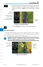
1. While viewing the Map page, touch the
Menu
key.
2. While viewing the Map Menu, touch the
Map Detail
and slide your finger to adjust the level. Features marked with
a • are shown at the indicated Map Detail (Declutter) Level.
Feature
0
1
2
3
Feature
0
1
2
3
River/Lake Names
•
TRSA
•
•
Land/Country Text
•
ADIZ
•
•
Large City
•
Alert Areas
•
•
Medium City
•
Caution Areas
•
•
Small City
•
Danger Areas
•
•
Small Town
•
Warning Areas
•
•
Freeways
•
Large Airports
•
•
•
Highways
•
Medium Airports
•
•
•
Roads
•
Restricted Areas
•
•
•
Railroads
•
Prohibited Areas
•
•
•
Political Boundaries
•
MOAs
•
•
•
User Waypoints
•
•
Runway Labels
•
•
•
VORs
•
•
Lightning Strike Data
•
•
•
NDBs
•
•
NEXRAD Data
•
•
•
Intersections
•
•
Traffic Symbols
•
•
•
Class B Airspace
•
•
Traffic Labels
•
•
•
Class C Airspace
•
•
Water Detail
•
•
•
•
Class D Airspace
•
•
Active FPL Legs
•
•
•
•
Tower
•
•
Airways
•
•
•
•
Table 8-18 Features Shown at Each Map Detail Level
Содержание GTN 625
Страница 608: ...This page intentionally left blank ...
Страница 609: ......
Страница 610: ...190 01004 03 Rev P ...


