Garmin GPSMAP A12 Скачать руководство пользователя страница 67

1

Apply an eyeglass lens cleaner specified as safe for anti-

reflective coatings to the cloth.

2

Gently wipe the screen with a soft, clean, lint-free cloth.

Viewing Images on a Memory card

You can view images that are saved on a memory card. You 

can view .jpg, .png, and .bmp files.

1

Insert a memory card with image files into the card slot.

2

Select 

Info

 > 

Image Viewer

.

3

Select the folder containing the images.

4

Wait a few seconds for the thumbnail images to load.

5

Select an image.

6

Use the arrows to scroll through the images.

7

If necessary, select 

Menu

 > 

Start Slideshow

.

Screenshots

You can capture a screenshot of any screen shown on your 

chartplotter as a .png file. You can transfer the screenshot to 

your computer. You can also view the screenshot in the image 

viewer (

Viewing Images on a Memory card

, page 59

).

Capturing Screenshots

1

Insert a memory card into the card slot.

2

Select 

Settings

 > 

Preferences

 > 

Screenshot Capture

 > 

On

.

3

Go to a screen you want to capture.

4

Hold 

Home

 for at least six seconds.

Copying Screenshots to a Computer

1

Remove the memory card from the chartplotter, and insert it 

into a card reader that is attached to a computer.

2

From Windows Explorer, open the Garmin\scrn folder on the 

memory card.

3

Copy a .bmp file from the card and paste it to any location on 

the computer.

Troubleshooting

My device will not acquire GPS signals

If the device is not acquiring satellite signals, there could be a 

few causes. If the device has moved a large distance since the 

last time it has acquired satellites or has been turned off for 

longer than a few weeks or months, the device may not be able 

to acquire the satellites correctly.
• Ensure the device is using the latest software. If not, update 

the device software.

• Make sure the device has a clear view of the sky so the 

antenna can receive the GPS signal. If it is mounted inside of 

a cabin, it should be close to a window so it can receive the 

GPS signal.

My device will not turn on or keeps turning off

Devices erratically turning off or not turning on could indicate an 

issue with the power supplied to the device. Check these items 

to attempt to troubleshoot the cause of the power issue.
• Make sure the power source is generating power.

You can check this several ways. For example, you can 

check whether other devices powered by the source are 

functioning.

• Check the fuse in the power cable.

The fuse should be located in a holder that is part of the red 

wire of the power cable. Check that the proper size fuse is 

installed. Refer to the label on the cable or the installation 

instructions for the exact fuse size needed. Check the fuse to 

make sure there is still a connection inside of the fuse. You 

can test the fuse using a multimeter. If the fuse is good, the 

multimeter reads 0 ohm.

• Check to make sure the device is receiving is at least 10 V, 

but 12 V is recommended.
To check the voltage, measure the female power and ground 

sockets of the power cable for DC voltage. If the voltage is 

less than 10 V, the device will not turn on.

• If the device is receiving enough power but does not turn on, 

contact Garmin product support.

My device is not creating waypoints in the correct 

location

You can manually enter a waypoint location to transfer and 

share data from one device to the next. If you have manually 

entered a waypoint using coordinates, and the location of the 

point does not appear where the point should be, the map 

datum and position format of the device may not match the map 

datum and position format originally used to mark the waypoint.
Position format is the way in which the GPS receiver's position 

appears on the screen. This is commonly displayed as latitude/

longitude in degrees and minutes, with options for degrees, 

minutes and second, degrees only, or one of several grid 

formats.
Map datum is a math model which depicts a part of the surface 

of the earth. Latitude and longitude lines on a paper map are 

referenced to a specific map datum.

1

Find out which map datum and position format was used 

when the original waypoint was created.
If the original waypoint was taken from a map, there should 

be a legend on the map that lists the map datum and position 

format used to create that map. Most often this is found near 

the map key.

2

Select 

Settings

 > 

Preferences

 > 

Units

.

3

Select the correct map datum and position format settings.

4

Create the waypoint again.

Contacting Garmin Support

• Go to 

support.garmin.com

 for help and information, such as 

product manuals, frequently asked questions, videos, and 

customer support.

• In the USA, call 913-397-8200 or 1-800-800-1020.
• In the UK, call 0808 238 0000.
• In Europe, call +44 (0) 870 850 1241.
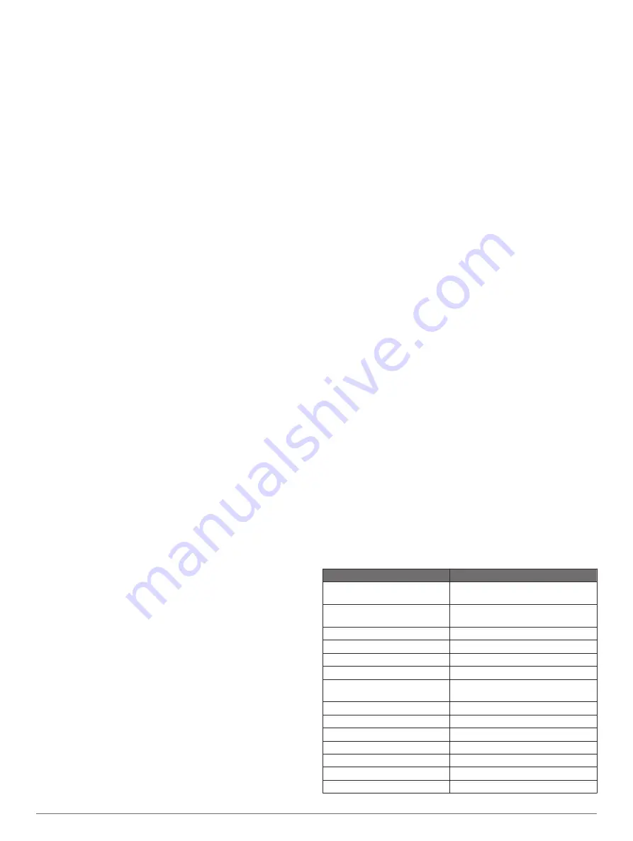
Specifications

Specification

Measurement

Dimensions (W × H × D)

330 × 226 × 79 mm (13 × 8.9 × 
3.1 in.)

Clearance to nearest 
obstruction

95 mm (3

3

/

4

 in.)

Weight

2.72 kg (6 lbs)

Display size (W × H)

262 × 163 mm (10.3 × 6.4 in.)

Display type

WXGA display

Display resolution

1280 x 800 pixels

Material

Die-cast aluminum and 
polycarbonate plastic

Water rating*

IEC 60529 IPX7

Temperature range

From -15° to 55°C (from 5° to 131°F)

Input voltage

From 10 to 32 Vdc

Typical current draw at 10 Vdc

3.5 A

Max. power draw at 10 Vdc

36 W

Max. current draw at 12 Vdc

3.0 A

Fuse

6 A, 125 V fast-acting

Appendix

59

Содержание GPSMAP A12

Страница 1: ...GPSMAP A12 Owner sManual...

Страница 2: ...elm Panoptix Reactor Shadow Drive SmartMode and SteadyCast are trademarks of Garmin Ltd or its subsidiaries These trademarks may not be used without the express permission of Garmin Apple is a tradema...

Страница 3: ...8 Navigating to a Point on the Chart 8 Premium Charts 8 Fish Eye 3D Chart View 9 Viewing Tide Station Information 9 Animated Tide and Current Indicators 9 Showing Tides and Current Indicators 9 Showi...

Страница 4: ...ilboat Autopilot Operation 22 Wind Hold 22 Setting the Wind Hold Type 22 Engaging Wind Hold 22 Engaging Wind Hold from Heading Hold 22 Adjusting the Wind Hold Angle with the Autopilot 22 Tack and Gybe...

Страница 5: ...U Turn Pattern 37 Setting Up and Following the Circles Pattern 37 Setting Up and Following the Zigzag Pattern 38 Following the Williamson Turn Pattern 38 Following an Orbit Pattern 38 Setting Up and F...

Страница 6: ...eather Data Broadcasts 46 Changing the Weather Chart 46 Viewing Precipitation Information 47 Storm Cell and Lightning Information 47 Hurricane Information 47 Weather Warnings and Weather Bulletins 47...

Страница 7: ...Memory Card 56 Copying Built In Maps to a Memory Card 56 Updating Built In Maps with a Memory Card and Garmin Express 57 Backing Up Data to a Computer 57 Restoring Backup Data to a Chartplotter 57 Sav...

Страница 8: ......

Страница 9: ...and functions Some buttons are accessible only in a combination page or SmartMode layout or when accessories such as a radar are connected Button Function Clears the on screen icons and re centers th...

Страница 10: ...le the device locates satellites It may take 30 to 60 seconds to acquire satellite signals When the device acquires satellite signals appears at the top of the Home screen If the device loses satellit...

Страница 11: ...n the station 1 From the home screen select SmartMode Menu Add Layout 2 Select an option To change the name select Name Symbol Name enter a new name and select Done To change the SmartMode symbol sele...

Страница 12: ...splash screen on your chartplotter 1 Insert a memory card that contains the image you want to use 2 Select Settings System Sounds and Display Startup Image Select Image 3 Select the memory card slot...

Страница 13: ...our mobile device 7 If necessary adjust which notifications you receive in your mobile device settings Receiving Notifications WARNING Do not read or reply to notifications while operating the vessel...

Страница 14: ...etwork 3 Enter a password You will need this password to access the wireless network from a wireless device The password is case sensitive Connecting a Wireless Device to the Chartplotter Before you c...

Страница 15: ...Charts and 3D Chart Views The charts and 3D chart views that are available depend on the map data and accessories used You can access the charts and 3D chart views by selecting Charts Nav Chart Shows...

Страница 16: ...rrected course may pass over land or shallow water Use visual sightings and steer to avoid land shallow water and other dangerous objects NOTE The Fishing chart is available with premium charts in som...

Страница 17: ...nd animated current direction indicators on the chart select Animated To enables the tides and current slider which sets the time for which tides and currents are reported on the map select Slider Sho...

Страница 18: ...ading information are provided by an activated AIS target but rate of turn information is not provided the projected course of the target is calculated based on the course over ground information Acti...

Страница 19: ...nd hides tracks on the 3D chart view Range Rings Shows and configures the appearance of range rings on the 3D chart view Range Rings help you to visualize distances in some chart views Chart Layer Set...

Страница 20: ...radient of the bottom with shading This feature is available only with some premium maps Sonar Imagery Shows sonar imagery to help show the density of the bottom This feature is available only with so...

Страница 21: ...in Quickdraw Contours Map You can add labels to a Garmin Quickdraw Contours map to mark hazards or points of interest 1 From the Navigation chart select a location 2 Select Quickdraw Lbl 3 Enter text...

Страница 22: ...your memory card TIP If you cannot find the file look in the Downloads folder The browser may have saved the file there 9 Remove the memory card from your computer 10Insert the memory card into the c...

Страница 23: ...g Go To page 15 How do I make the device guide me along a straight line minimizing cross track to a location using the shortest distance from the present location Build a single leg route and navigate...

Страница 24: ...User Data Waypoints 2 Select a waypoint 3 Select Review Edit 4 Select an option To add a name select Name and enter a name To change the symbol select Symbol To change the depth select Depth To chang...

Страница 25: ...ou must create and save at least one route 1 Select Info User Data Routes Auto Guidance Paths 2 Select a route 3 Select Navigate To 4 Select an option To navigate the route from the starting point use...

Страница 26: ...structions To delete the path select Cancel Auto Guidance To save the path select Done Adjusting a Saved Auto Guidance Path 1 Select Info User Data Routes Auto Guidance Paths 2 Select a path and selec...

Страница 27: ...o Guidance line and determine whether the line safely avoids known obstacles and the turns enable efficient travel Auto Guidance maintains a wide clearance from obstacles in open water even if you set...

Страница 28: ...oute to a Boundary Before you can convert a route to a boundary you must create and save at least one route Creating and Saving a Route page 17 1 Select Info User Data Routes Auto Guidance Paths 2 Sel...

Страница 29: ...ault 1 From the Sail Racing combination screen select Start NOTE You can also access this from the Sailing SmartMode screen and the navigation chart 2 When necessary select Sync to synchronize with th...

Страница 30: ...is engaged To adjust the wind hold angle in increments of 1 select or To adjust the wind hold angle in increments of 10 hold or Tack and Gybe You can set the autopilot to perform a tack or gybe while...

Страница 31: ...ew you can separately adjust the gain for each frequency If you do not see an arrangement of sonar views to suit your needs you can create a custom combination screen Creating a New Combination Page p...

Страница 32: ...rom the current location of the pin select Set Reference Panoptix Sonar Views NOTE Not all models support Panoptix transducers To receive Panoptix sonar you need a compatible chartplotter and a compat...

Страница 33: ...h FrontV sonar decreases as your speed rises above 8 knots To see the FrontV sonar view you must install and connect a compatible transducer such as a PS21 transducer You may need to update the transd...

Страница 34: ...by adjusting the Interference sonar setting Adjusting the Level of Detail You can control the level of detail and noise shown on the sonar screen either by adjusting the gain for traditional transduce...

Страница 35: ...ect an option To adjust the scroll speed automatically using speed over ground or water speed data select Auto The Auto setting selects a scroll rate to match the boat speed so targets in the water ar...

Страница 36: ...etting the FrontV Depth Alarm page 30 This alarm is available only with Panoptix FrontV transducers Water Temp Sets an alarm to sound when the transducer reports a temperature that is 2 F 1 1 C above...

Страница 37: ...e of an orca whale pod It is your responsibility to use the device in compliance with all applicable laws and ordinances 1 From a sonar view select Menu Frequency 2 Select a frequency suited to your n...

Страница 38: ...t a particular area of interest For example you might aim the transducer to follow a bait ball or focus on a tree as you pass it 1 From a LiveV or FrontV sonar view select Menu Transmit Angle 2 Select...

Страница 39: ...location This allows you to view the forward distance from the bow instead of the transducer installation location This feature applies to Panoptix transducers in the FrontV LiveV Forward and RealV 3D...

Страница 40: ...structions 2 Turn on the chartplotter If necessary the radar warms up and a countdown alerts you when the radar is ready 3 Select Radar 4 Select a radar mode A countdown message appears while the rada...

Страница 41: ...the guard zone 5 Select Done MARPA Mini automatic radar plotting aid MARPA enables you to identify and track targets and is primarily used for collision avoidance To use MARPA you assign a MARPA tag...

Страница 42: ...n Echo Trails The echo trails feature enables you to track the movement of vessels on the radar display As a vessel moves you can see a faint trail of the vessel s wake You can change the length of ti...

Страница 43: ...tter and targets A higher sea clutter setting reduces the appearance of clutter caused by nearby waves but it can also reduce or eliminate the appearance of nearby targets NOTE Depending upon the rada...

Страница 44: ...sates for the physical location of the radar scanner on a boat if the radar scanner does not align with the bow stern axis Measuring the Potential Front of Boat Offset The front of boat offset compens...

Страница 45: ...not display any data Autopilot Overlay Bar Actual heading Intended heading heading the autopilot is steering toward Actual heading when in standby mode Intended heading when engaged Engaging the Autop...

Страница 46: ...cancel a pattern using step steering mode Select Standby Enabling the Autopilot Controls on a Garmin Watch You can control the Garmin autopilot with a compatible Garmin watch Go to www garmin com for...

Страница 47: ...r screen prompting you to activate navigation to the man overboard location disappears Man Overboard and SOS Distress Calls Initiated from the Chartplotter When your chartplotter is connected to a Gar...

Страница 48: ...s how the gauges pages are displayed and the data in each gauge 1 Open a gauge page 2 Select Menu Edit Gauge Pages 3 Select an option To change the data shown in a gauge select the gauge To change the...

Страница 49: ...top the engine when this alert is on If you do you may not be able to restart the engine Water in the fuel Water has collected in the fuel filter fuel separator Stop the engine immediately and consult...

Страница 50: ...u can configure the sailing wind gauge to show true or apparent wind speed and angle 1 From the wind gauge select Menu Sailing Wind Gauge 2 Select an option To show true or apparent wind angle select...

Страница 51: ...and for the present date and time Select Info Tides Currents Currents Celestial Information You can view information about sunrise sunset moonrise moonset moon phase and the approximate sky view loca...

Страница 52: ...a screen select Source NOTE After few moments the compatible FUSION PartyBus stereos appear as sources 2 Select the FUSION PartyBus stereo 3 If necessary select Source and select a different source co...

Страница 53: ...lable station in the next ensemble Selecting a DAB Station from a List 1 From the DAB media screen select Browse Stations 2 Select a station from the list Selecting a DAB Station from a Category 1 Fro...

Страница 54: ...e on compatible connected stereos and accessories 1 Go to www fusionentertainment com marine and download the software update onto a USB flash drive Software updates and instructions are available on...

Страница 55: ...ine forecasts warnings hurricane warnings METARS county warnings weather fronts and pressure centers surface pressure and weather buoys Viewing Forecast Information for Another Time Period 1 Select Ch...

Страница 56: ...left of the screen Variations in the visibility shading show the forecast change in surface visibility NOTE This feature is not available on all devices and in all subscriptions Select Charts Visibil...

Страница 57: ...ameras provide additional options to control the camera view NOTE Not all options are available on all camera models and chartplotter models Refer to the camera manual for a list of available features...

Страница 58: ...mobile device go to the Wi Fi settings on your mobile device and connect to the camera access point using the name and password on the camera screen 5 On your mobile device start the GarminVIRB app T...

Страница 59: ...Rotation Allows you to rotate the camera angle Adding the VIRB Action Camera Controls to Other Screens Before you can control a VIRB action camera with the chartplotter you must connect the devices u...

Страница 60: ...Select System 3 Select Regulatory Information Preferences Settings Select Settings Preferences Units Sets units of measure Language Sets the on screen text language Navigation Sets navigation prefere...

Страница 61: ...eposition the Auto Guidance line unless the destination selected requires navigation through a narrow waterway 8 Select an option If the placement of the Auto Guidance line is satisfactory select Menu...

Страница 62: ...is available only with Panoptix FrontV transducers Water Temp Sets an alarm to sound when the transducer reports a temperature that is 2 F 1 1 C above or below the specified temperature Contour Sets...

Страница 63: ...a positive number if the sensor connected to the chartplotter measures the water temperature as being colder than it actually is Enter this value in step 5 as a negative number if the sensor connected...

Страница 64: ...s from HomePort to a Chartplotter Before you can copy data to the chartplotter you must have the latest version of the HomePort software program loaded on your computer and a memory card installed in...

Страница 65: ...ter support you by completing our online registration today Keep the original sales receipt or a photocopy in a safe place 1 Insert a memory card into the card slot Inserting Memory Cards page 2 2 Wai...

Страница 66: ...erent cables voids your warranty Through the HDMI OUT port you can duplicate the chartplotter screen on another device such as a television or monitor The Garmin GPSMAP HDMI accessory cable is 4 5 m 1...

Страница 67: ...ed Refer to the label on the cable or the installation instructions for the exact fuse size needed Check the fuse to make sure there is still a connection inside of the fuse You can test the fuse usin...

Страница 68: ...84 Alert Response 127497 Trip parameters Engine Receive PGN Description 065030 Generator average basic AC quantities GAAC 126983 Alert 126985 Alert text 126987 Alert threshold 126988 Alert value 12699...

Страница 69: ...Association NMEA format and sentences from NMEA Seven Riggs Avenue Severna Park MD 21146 USA www nmea org J1939 PGN Information The chartplotter can receive J1939 PGN sentences The chartplotter cannot...

Страница 70: ...all user data 20 depth log 43 depth shading 11 12 14 destinations navigation chart 15 selecting 15 detailed maps 56 57 device cleaning 58 registration 57 digital selective calling 38 39 channels 40 co...

Страница 71: ...auges 42 sailingstarting line 21 SART 10 11 satellite imagery 9 satellite signals acquiring 2 screen brightness 4 locking 1 unlocking 1 screenshots 59 capturing 59 settings 14 51 52 radar display 36 s...

Страница 72: ...2 46 fishing 48 forecast 47 48 overlay 48 precipitation 47 sea conditions 47 48 subscription 46 48 surface pressure 48 visibility 48 water temperature 48 wave information 48 winds 47 Wi Fi 5 Wi Fi tec...

Страница 73: ......

Страница 74: ...support garmin com December 2018 190 02262 00_0D...

Отзывы: