background image

GPSMAP 5000 Series Owner’s Manual

Configuring the 

Device

C

onfi

GU

rin

G


the

 d

eV

iC

e

Configuring XM Audio


Note: 

You must connect optional Garmin XM equipment (such as a GDL 30A XM receiver) to the 

Garmin Marine Network, and have a subscription to XM Radio to use XM audio features. For more 

information, refer to 

page 59

.

From the Home screen, touch 

Configure

 > 

XM audio

.

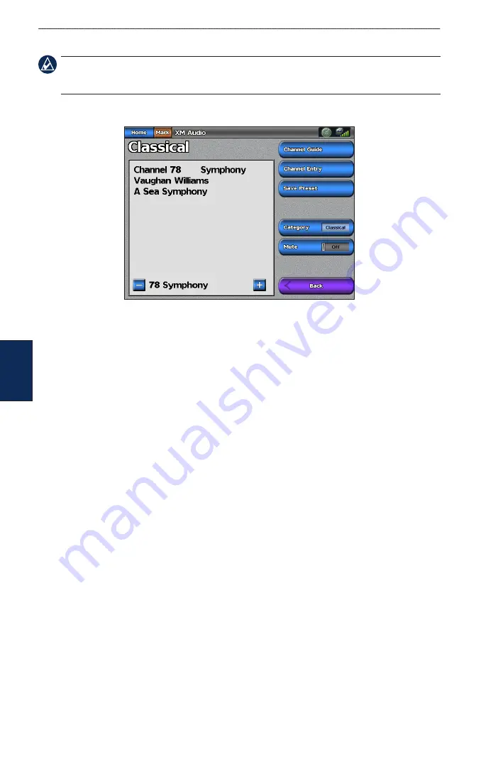
Channel Guide

—selects the specific XM channel within the currently selected category.

Channel entry

—allows you to enter a channel using the screen keyboard.

Save Preset

—saves the current XM channel in the Presets list. Touch 

Delete Preset

 to remove the 

current channel from the list. Presets is displayed as a category in the category list.

Category

—selects the category of channels that are displayed in the Channel Guide.

Mute

—silences the audio.

Содержание GPSMAP 5215

Страница 1: ...GPSMAP 5000 Series owner s manual...

Страница 2: ...is manual must contain the complete text of this copyright notice and provided further that any unauthorized commercial distribution of this manual or any revision hereto is strictly prohibited Inform...

Страница 3: ...ss and release the Power key to adjust the display settings Backlight and Color Mode Press and hold the Power key to turn the chartplotter on or off Manual Conventions In this manual when you are inst...

Страница 4: ...onfiguring Navigation Preferences 36 Configuring Units of Measure 37 Configuring Communications Settings 38 Setting Alarms 39 Setting the Total Fuel Onboard Alarm 40 Configuring My Boat 40 Configuring...

Страница 5: ...ies Owner s Manual Getting Started G etting S tarted Getting Started Front and Rear Panels SD card slot Power key Automatic backlight sensor GPSMAP 5208 Front Network NMEA 2000 Video Power NMEA 0183 G...

Страница 6: ...lso be configured when restoring factory settings page 4 All of these settings can be configured later from the Configure screen page 36 The initial settings are as follows Language touch the language...

Страница 7: ...automatically adjust the backlight based on ambient light touch Auto To manually adjust the backlight either touch and hold Up or Down or touch and drag the brightness bar Brightness bar Adjusting th...

Страница 8: ...ble You may need this information to update the system software or purchase additional map data information From the Home screen touch Configure System System Information Using the Simulator Mode Simu...

Страница 9: ...ar and video in a 2 3 or 4 field split screen page 21 Information shows information including tides currents celestial data user data information about other boats gauges and video page 30 Mark marks...

Страница 10: ...d enhances bottom contours for depth recognition Fish Eye 3D provides an underwater view that visually represents the sea floor according to the chart s information The chartplotter selectively displa...

Страница 11: ...n the Fuel Rate Remaining Fuel Range and Fuel Economy data bar on or off Sailing turn the Water Speed Wind Speed Wind Angle and Wind Velocity Made Good VMG data bar on or off Select Wind to toggle bet...

Страница 12: ...t Harbor Current Station Marine Services Some symbols might appear differently on your Garmin chartplotter Other features common to most charts include depth contour lines with deep water represented...

Страница 13: ...point on the Navigation screen without dragging a cursor appears at that spot and a list of options appear along the right side You can touch and drag the pointer to a new location As you move the cur...

Страница 14: ...rmation about on screen map items waypoints and charts 2 Touch the button with the name of the item to view the information Object Selected on a GPSMAP 5208 Selected item Additional object information...

Страница 15: ...cating compass direction True wind direction or apparent wind direction can be displayed if the chartplotter is connected to a compatible marine wind sensor Compass rose Wind direction indicator Wind...

Страница 16: ...ntour is always drawn at or deeper than the selected depth Symbols changes symbol preferences Navaid Size adjusts the size of the navaid symbols shown on the map Navaid Type selects the navaid symbol...

Страница 17: ...25 Active Tracks manage tracks page 14 Saved Tracks view a list of tracks that have been saved Other Vessels view information about other vessels To view information about other vessels your chartplo...

Страница 18: ...ion the time the current track began or Midnight if shown or Entire Log 3 Touch Edit Track to name the track to change the color of the track or to save it as a route To clear the active track From th...

Страница 19: ...interval Track Color sets the color of the track plot Using BlueChart g2 Vision Optional BlueChart g2 Vision preprogrammed SD cards allow you to get the most out of your chartplotter In addition to de...

Страница 20: ...ourse and provides a visual navigation aid This view is helpful when navigating tricky shoals reefs bridges or channels and when trying to identify entry and exit routes in unfamiliar harbors or ancho...

Страница 21: ...azard Colors For settings and options related to Range Rings Safe Depth and Lane Width see page 11 Using Fish Eye 3D Using the depth contour lines of the BlueChart g2 Vision cartography Fish Eye 3D pr...

Страница 22: ...ellite images on the land the sea or both portions of the Navigation chart when using a preprogrammed BlueChart g2 Vision SD card NOTE When enabled the high resolution satellite images are only presen...

Страница 23: ...ne 2 Select Aerial Photo Note Touch and to zoom in and out while viewing the aerial photo on the full screen Viewing Current Station Information If current stations are available in your BlueChart g2...

Страница 24: ...rts Using Automatic Guidance Automatic Guidance automatically creates and suggests passage based on available BlueChart g2 Vision chart information See page 40 for instructions on setting up Automatic...

Страница 25: ...ch a combination Interacting with the Combinations Screen You can view a combination screen at full screen and change the data field pane on the right side of the screen To add additional data fields...

Страница 26: ...ncrease the number of screens available use a BlueChart g2 Vision SD card or add network devices such as sonar and radar Touch Functions to select the number of combination screens Touch Layout to cha...

Страница 27: ...g2 Vision chart data to suggest the best path to your destination You must be using a BlueChart g2 Vision SD card for this option to appear Caution Guide To does not assure obstacle and bottom clearan...

Страница 28: ...n Card To stop navigating From the Navigation chart touch Menu Stop Navigation To search for a destination by name 1 From the Home screen touch Where To Search by Name 2 Touch characters to spell at l...

Страница 29: ...ocation as a Man Overboard location Next Page Previous Page switch between waypoint information and the Navigation chart Back save the waypoint and returns to the Navigation chart Note Touching Mark c...

Страница 30: ...avigation chart 2 If there are multiple waypoints in the vicinity touch Review 3 Touch the button for the waypoint you want to edit 4 Touch Move 5 Touch Use Chart or Enter Position 6 Complete one of t...

Страница 31: ...on chart touch your destination The destination is indicated by a cursor 2 Touch Navigate To Route To 3 Touch the location where you want to make the last turn toward your destination 4 Touch Add Turn...

Страница 32: ...oute 3 Touch Add Turn to mark the starting point of the route 4 Touch the location of the first turn and then touch Add Turn Repeat until the route is complete 5 Touch Done To create a route using Aut...

Страница 33: ...formation User Data Routes 2 Touch the route to edit 3 Touch Review Delete To bypass a waypoint on a route 1 Create a route as previously described 2 From the Navigation chart touch the waypoint that...

Страница 34: ...the Home screen touch Information Tides Currents Tides Information for the most recently viewed tide station is shown Tide station Local time Current tide height Time of next high tide 2 Select an op...

Страница 35: ...moonrise moonset moon phase and approximate sky view location of the sun and moon By default the chartplotter displays celestial information for the current date and time From the Home screen touch In...

Страница 36: ...nsfer Send to Device 5 Select the drive for the SD card reader and the types of data you want to copy to your chartplotter 6 Click Send 7 Insert the SD card into your chartplotter 8 From the Home scre...

Страница 37: ...written on those chartplotters Touch Merge User Data to transfer data between all the chartplotters connected to the network Unique data is combined with existing data on every chartplotter To back up...

Страница 38: ...stallation Instructions for details From the Home screen touch Information Dashboard Gauges To select analog or digital gauges Note For more than two engines you can only use the digital gauges For on...

Страница 39: ...eo 2 that displays the video If you have two video sources and wish to alternate between the two touch Alternate to define the amount of time each video screen is displayed Aspect switches between the...

Страница 40: ...lor Mode touch Color Mode to select Day Colors or Night Colors or touch Auto to allow the chartplotter to adjust the colors Screenshot Capture turn the screenshot capture feature on or off page 68 GPS...

Страница 41: ...Custom to individually define units of measure for Depth individually set the units of measure for depth to Feet Fathoms or Meters Temperature individually set the units of measure for temperature to...

Страница 42: ...sentences See page 69 for information on configuring these sentences Posn Precision adjust the number of digits Two Digits Three Digits or Four Digits to the right of the decimal point for transmissio...

Страница 43: ...und If you have Activation set to Distance touch Change Distance to set the distance before arrival that the alarm should sound Use the on screen keyboard to change the time or distance Anchor Drag se...

Страница 44: ...ouch Configure Alarms Fuel Total Fuel Onboard On 2 Use the on screen keyboard to indicate the fuel level at which the alarm should sound To disable the Total Fuel Onboard alarm From the Home screen to...

Страница 45: ...ve number shows depth at the surface Configuring Other Vessels NOTE To configure Automatic Identification System AIS or Digital Selective Calling DSC information for other boats your chartplotter must...

Страница 46: ...er to page 59 From the Home screen touch Configure XM Audio Channel Guide selects the specific XM channel within the currently selected category Channel Entry allows you to enter a channel using the s...

Страница 47: ...onar data when connected to the Garmin Marine Network and an appropriate transducer Sonar data is shared by all chartplotters on the network GMR 21 41 Radome GMR 18 Radome and GMR 404 406 Open Array R...

Страница 48: ...re Communications Marine Network Each connected device is listed along the left side of the screen Network Devices Name defined No name defined To assign a name to one of the devices 1 From the Home s...

Страница 49: ...oking directly at the radar because the eyes are the most susceptible part of the body To turn on the radar 1 Power on the network The radar warms up and a countdown is provided to alert you when the...

Страница 50: ...m scale is set at three miles each ring represents one mile from the center out Adjust the zoom scale using the and buttons Using Sentry Mode NOTE When Sentry mode is enabled all MARPA targets are can...

Страница 51: ...to completely encompass the boat Use Corner 1 or Corner 2 to adjust the size Corner 1 Corner 2 Circular Radar Targeting Note MARPA requires the use of a heading sensor The heading sensor must output t...

Страница 52: ...ormation on the Navigation chart To access the radar overlay screen 1 From the Home screen touch Radar Radar Overlay The radar picture appears in orange and overlays the Navigation chart 2 Use the and...

Страница 53: ...Medium or Calm Touch Up or Down to manually adjust the sea clutter sensitivity Touch Cross Talk to filter out interference caused by another radar operating in close proximity Touch FTC Fast Time Con...

Страница 54: ...r from 500 ft to 2 0 mi Time To Safe Zone sounds an alarm if AIS or MARPA determines that a target will intersect the Safe Zone within the defined time interval ranging from 1 to 24 minutes Advanced R...

Страница 55: ...he Home screen touch Sonar Full Screen The range scale along the right side of the screen shows the depth of detected objects as the screen scrolls from the right to the left Sonar Full Screen Suspend...

Страница 56: ...ucer frequencies Range Understanding the Temp Log If you are using a temperature capable transducer the Temp Log screen keeps a graphic log of temperature readings over time 1 From the Home screen tou...

Страница 57: ...is shown Configuring Sonar Appearance From the Home screen touch Sonar Sonar Setup Appearance Fish Symbols sets how the sonar interprets suspended targets The chartplotter does not interpret the sona...

Страница 58: ...see page 25 Frequency select how the frequencies appear on screen 200kHz 50kHz or Dual when using a dual frequency transducer Zoom zoom in to a section of the Full screen The zoom is off No Zoom by de...

Страница 59: ...8 X When you initiate a man overboard distress call from your radio the chartplotter displays the man overboard screen and prompts you to navigate to the man overboard point page 56 X When you initiat...

Страница 60: ...sel and touch Trail Line to change the line color Select Clear Report to delete the call report Select Navigate To to Go To or Route To the position sent with the distress call page 23 The symbol mark...

Страница 61: ...essel name and add a comment If your radio is tracking the position of the vessel touch Trail to show or hide the trail line for the vessel and touch Trail Line to change the line color Select Clear R...

Страница 62: ...on of a DSC channel is limited to those channels that are available in all frequency bands 6 8 9 10 13 15 16 17 67 68 69 71 72 73 or 77 NOTE The default channel is 72 Select Channel to select a differ...

Страница 63: ...ather for more information Note Any weather feature can change in appearance or interpretation if the source that provides the information changes XM WX Weather data is broadcast at set rates For exam...

Страница 64: ...Lightning strikes are represented by lightning bolt icons Lightning appears on the map if strikes were detected within the last seven minutes The ground based lightning detection network only detects...

Страница 65: ...corresponding to the warning To view information about the warning touch the county Tornado Warning Severe Thunderstorm Warning Flood Warning Flash Flood Warning Viewing Forecast Information Forecasts...

Страница 66: ...counterclockwise around low pressure centers in North America Indicates a high pressure center A high pressure center is an area where the measured pressure is highest relative to the surrounding area...

Страница 67: ...n Understanding Wave Height The Wave Height feature shows wave heights The wave heights for an area are shown in color intensities Understanding Wave Period The Wave Period feature provides the time i...

Страница 68: ...ches of Mercury in and Hectopascals hPa Understanding Water Temperature Data The Water Temperature feature indicates the water s surface temperature as indicated by the legend on the left of the scree...

Страница 69: ...is shown 2 Touch Next Forecast again to view forecasts for the next 24 and 36 hours Viewing Buoy Reports Report readings are taken from buoys and coastal observation stations These readings are used...

Страница 70: ...dio Channel Touch the right or left channel select arrows to change to the next channel in the current category To use the XM Audio Guide Touch the channel display bar Channel Guide selects the specif...

Страница 71: ...PSMAP 5208 31 in 80 cm GPSMAP 5212 39 in 1 m GPSMAP 5215 15 in 40 cm Hg Lamps inside this product contain mercuryand must be recycled or disposed ofaccording to local state or federal laws For more in...

Страница 72: ...rmin RF Wireless Remote Control You can capture a screenshot of any screen displayed on your chartplotter as a bitmap BMP file and then transfer it to your computer To capture screenshots 1 Insert an...

Страница 73: ...E GPVTG GPWPL GPXTE and Garmin proprietary sentences PGRME PGRMM and PGRMZ This chartplotter also includes support for the WPL sentence DSC and sonar NMEA 0183 input with support for the DPT depth or...

Страница 74: ...Enough to Calibrate speed sensor appears during water speed calibration Check speed wheel for blockage and calibrate again If wheel is clear calibrate again and increase speed Calibration is complete...

Страница 75: ...Incompatible Device Software Update Required an incompatible device is attached that requires a software update Contact product support for assistance updating your network Invalid Date an invalid dat...

Страница 76: ...defined proximity point Proximity Alarm Memory is Full the proximity waypoint memory is full Erase existing proximity waypoints to make room Proximity Overlaps Another Proximity Waypoint a proximity...

Страница 77: ...er Card Not Found user data card transfer Make sure an SD card is fully inserted Warning Auto guidance route starting position moved due to safe depth settings BlueChart g2 Vision auto guidance has ca...

Страница 78: ...ature and therefore cannot be relied upon as safety critical in connection with any aircraft sea craft or automobile usage This information is provided as is and XM and Garmin disclaim any and all war...

Страница 79: ...BY THE TERMS AND CONDITIONS OF THE FOLLOWING SOFTWARE LICENSE AGREEMENT PLEASE READ THIS AGREEMENT CAREFULLY Garmin grants you a limited license to use the software embedded in this device the Softwar...

Страница 80: ...t settings 2 depth 37 53 detail 11 device list 38 DSC 41 55 E EBL 49 elevation unit settings 37 event log 36 F factory settings 2 4 fishing 63 fish symbols 53 flash flood warning 61 flood warning 61 f...

Страница 81: ...gs 37 split frequency radar 52 split zoom radar 51 spot depths 12 stationary front 62 storm cells 59 sunrise sunset 31 surface noise 53 surface radar 13 surface winds 62 symbols 8 12 system informatio...

Страница 82: ......

Страница 83: ......

Страница 84: ...2009 Garmin Ltd or its subsidiaries Garmin International Inc 1200 East 151st Street Olathe Kansas 66062 USA Garmin Europe Ltd Liberty House Hounsdown Business Park Southampton Hampshire SO40 9LR UK G...

Отзывы: