


4
GPSMAP
®
400 Series Owner’s Manual
u
SInG
c
hartS
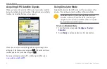
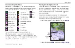
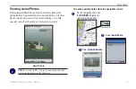
Enabling High Resolution Satellite Imagery
You can overlay high-resolution satellite images on the land, sea, or
both portions of the navigation chart when using a preprogrammed
BlueChart g2 Vision SD card.
NOTE:
This feature is preloaded on the GPSMAP
430/430s/430x/430sx units.
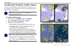
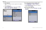
To enable satellite imagery:
1. While viewing the
Navigation Chart
, press
MENU
.
2. Select
Chart Setup
>
Appearance
>
Photos
.
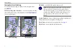
3. Select one of the following options:
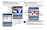
•
Off
—standard chart information is shown on the map.
•
Land Only
—standard chart information is shown on
water with photos overlaying the land.
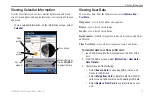
•
On
—photos overlay both the water and the land at a
specified opacity. The higher you set the percentage, the
more the satellite photos will cover both land and water.
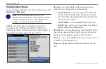
NOTE:
When enabled, the high resolution satellite images are
only present at lower zoom levels. If you cannot see the high
resolution images in your BlueChart g2 Vision region, either
zoom in further using the
RANGE (+)
key, or set the detail level
).
Photo Overlay Off
Land Only Photo Overlay
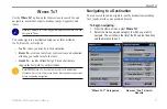
Photo Overlay at 50%
Photo Overlay at 100%
Содержание GPSMAP 400 series
Страница 1: ...GPSMAP 400 series owner s manual ...
Страница 71: ......