background image

GPSMAP 3006C/3010C Owner’s Manual 

69

M

AIN

 M

ENU

 > 

M

AP

 T

AB

• 

Spot Soundings

—turns on the depth spot sounding data. Select 

On

,  

Warn Depth

, or 

Off

.

• 

Warn Depth

—shows the spot sounding below the set value in red. This 

field is available only when 

Warn Depth

 is selected in the Spot Soundings 

field.

•  Orientation

—sets the orientation of the map display:

  • 

North Up

—fixes the top of the map display to a north heading.

  • 

Track Up

—fixes the top of the map display to the current track    

  heading. Set to 

All Ranges

 for constant Track Up. The numeric value is  

  the map range at which the unit switches to North Up when zooming  

  out.

  • 

Course Up

—fixes the map so the direction of navigation is always up  

  and turns the course line vertical on the screen.

•  Defaults

—restores map settings to factory defaults for all tabs. Press the 


Defaults

 soft key to restore original settings.

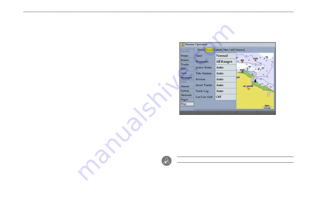
Detail Sub Tab 

Use the Detail sub tab to control the amount of detail for charts, waypoints, active 

routes, Tide Stations, services, saved tracks, and track logs shown on the Map 

Page.

•  Chart

—controls how much map detail you see and which charts the unit 

chooses to use for a particular zoom range. Select 

Most

More

Normal

Less

, or 

Least.

•  Chart

Waypoints

Active Route

Tide Stations

Services

Lat/Lon 

Grid

—sets the maximum scale at which the feature should appear on-

screen. Select 

Off

All Ranges

Auto

, or

 <30 ft

 to 

<800 nm


NOTE: 

Some types of data only show up to certain zoom scales. 

Содержание GPSMAP 3006C

Страница 1: ...GPSMAP Owner s Manual 3006C 3010C GPSMAP 3010C shown...

Страница 2: ...rint one copy of this manual or of any revision hereto provided that such electronic or printed copy of this manual must contain the complete text of this copyright notice and provided further that an...

Страница 3: ...ection provides a unit overview and information that provides basic working knowledge needed to use the GPSMAP 3006C 3010C The Basic Operation section provides you with details and step by step instru...

Страница 4: ...the Features 9 Selecting Options and Entering Data 10 Using Additional Map Data 11 Using the Map Pointer 11 Finding an Item 13 Creating and Using Waypoints 14 Creating Waypoints Using the ENTER MARK K...

Страница 5: ...lls 55 Understanding Position Reports 55 Review DSC Waypoint 55 Setting Up DSC 56 Using the NAV Key 56 Card Tab 57 Messages Tab 58 Viewing Detailed Message Information 58 Alarms Tab 59 System Alarms 5...

Страница 6: ...rds 90 Satellite Information 91 What is WAAS EGNOS 91 WAAS Capability 92 Digital Selective Calling DSC 92 What is DSC 92 LORAN TD System 94 Caring for the GPSMAP 3006C 3010C 95 Navigation Terms 96 Mes...

Страница 7: ...HE TERMS AND CONDITIONS OF THE FOLLOWING SOFTWARE LICENSE AGREEMENT PLEASE READ THIS AGREEMENT CAREFULLY Garmin grants you a limited license to use the software embedded in this device the Software in...

Страница 8: ...our Web site at http www garmin com prop65 Failure to avoid the following potentially hazardous situations may result in injury or property damage Use the GPSMAP 3006C 3010C only as a navigational ai...

Страница 9: ...STARTED UNIT OVERVIEW GETTING STARTED Unit Overview Connection ports Serial number tag Soft keys Data entry keys Data card slots Interface keys Infrared IR window For optional remote control Data card...

Страница 10: ...or left to move through lists highlight elds enter data or move the map pointer NAV MOB Key Press to open the Navigation menu Press and hold to mark a MOB waypoint and create a track back to the mark...

Страница 11: ...MARK keys press and hold the key The Thumb Stick combines the operations of the ROCKER and ENTER MARK key Use it to select menu options change settings enter data and con rm entry You can also control...

Страница 12: ...have selected the correct letter or number pause and the unit advances the cursor to the next character automatically Use the shortcut keys to jump to main pages or select menu and list options by pr...

Страница 13: ...MAP 3006C 3010C 1 Press and hold the POWER key until the unit turns on 2 When I Agree is highlighted on the Warning Page press ENTER to open the Map Page To turn off the GPSMAP 3006C 3010C Press and h...

Страница 14: ...accuracy is available on the GPS tab on the Main Menu To view the GPS tab information 1 Press and hold ADJ MENU to open the Main Menu 2 Use the ROCKER to highlight the GPS tab When viewing the GPS Inf...

Страница 15: ...ons in 2D or 3D and a D appears on the strength bar of satellites being corrected After the receiver has collected information from at least three satellites the Status eld shows either Ready for Navi...

Страница 16: ...ating Operation appears in the status bar at the top of each page To set up Simulator Mode Highlight the Setup button and press ENTER The Simulator Setup window appears The following options are avail...

Страница 17: ...right with the ROCKER to select individual elds Moving the highlight to a given location allows you to make a selection begin data entry or scroll through a list Field the location on a page where da...

Страница 18: ...e the ROCKER to highlight an on screen button and press ENTER To select an option using soft keys Press the button below the soft key you want to select To select an option using data entry shortcut k...

Страница 19: ...rspective tide and current data improved IALA symbols navaids marinas boat ramps roads and more You can also access additional data including highly detailed coastal roads and points of interest such...

Страница 20: ...int or map item is selected it is highlighted on screen with the name and location shown 2 Press ENTER to view details of the map item When using BlueChart or MapSource data or if waypoints are groupe...

Страница 21: ...ave a By Name tab For By Name select the top eld to spell out the name or scroll through the list 4 Some items have a Filter List button that allows you to enter letters or numbers of the item name Th...

Страница 22: ...hold ENTER MARK until the Review Waypoint Page appears The GPSMAP 3006C 3010C captures its current location and creates a default name and symbol for the new waypoint 2 To accept the waypoint with the...

Страница 23: ...s Manually You can manually enter position coordinates to create a waypoint using the Points tab on the Main Menu This method is useful for creating a waypoint at a speci c latitude longitude position...

Страница 24: ...To add a new waypoint to a route 1 Press the Add To Route soft key The Select Route Page appears 2 Highlight a route or New Route and press ENTER 3 Press the OK soft key to add the waypoint to the rou...

Страница 25: ...se the ROCKER to select a different symbol and press ENTER Waypoint Symbol List To change the Comment Position Depth or Water temp 1 Highlight the Comment Position Depth or Water temp eld and press EN...

Страница 26: ...rom the waypoint s current location appears in the upper left corner of the map window 3 Press ENTER to accept the new waypoint location 4 Press FCTN to return to the left side of the Review Waypoint...

Страница 27: ...ailable when you highlight a waypoint on the User sub tab New Waypoint creates a new waypoint Delete deletes the selected waypoint from the list and from any route in which the waypoint was used Del b...

Страница 28: ...Alarm soft key on the Proximity sub tab The Find From Current Position Page appears 2 Highlight a category and press ENTER 3 Use the ROCKER to highlight a waypoint or map item and press ENTER The Revi...

Страница 29: ...so choose to go to other points from this list such as cities or Tide Stations 4 Select a waypoint and press ENTER to open the Review Waypoint Page for the selected waypoint 5 Press the Go To soft key...

Страница 30: ...tions navigate in the same way Follow Track uses stored or saved tracks TracBack uses your current or active track TracBack allows you to retrace your path using the track log stored in the receiver s...

Страница 31: ...he Saved Track Page appears The default name distance number of points 700 maximum and a map overview are shown 5 To change the name of the saved track highlight the Name eld and press ENTER make any...

Страница 32: ...track log stored in memory and divides it into segments called legs Up to 300 temporary turns BEGIN TURN 1 TURN 2 TURN X END are created to mark the most signi cant features of the track log to dupli...

Страница 33: ...es numbered 1 50 with up to 300 points each Creating a New Route Using the Route tab on the Main Menu you can create a new route in one of two ways You can select waypoints or map items on the map win...

Страница 34: ...o add the point to the route As you add each new waypoint to the route the Route list shows the waypoint or map item name leg distance course between points and a selectable column to show other route...

Страница 35: ...3 Use the map pointer to select a waypoint or map item and press ENTER As you add each new waypoint to the route the data window at the top of the Map Page shows the waypoint or map item name bearing...

Страница 36: ...routes 1 Press and hold ADJ MENU to open the Main Menu and then highlight the Routes tab 2 Press the Delete All soft key A con rmation message appears 3 Highlight OK and press ENTER to delete all rout...

Страница 37: ...he Delete soft key to permanently delete the waypoint from the unit or press the Next soft key to highlight the next point on the route list If the selected route point is a user waypoint you can edit...

Страница 38: ...ed route 2 Select the point you want to remove from the route and press the Remove soft key To graphically edit a route on the map 1 On the Routes tab highlight the route you want to edit and press EN...

Страница 39: ...ure statute nautical or metric do not affect the fuel ow measure You should enter fuel ow rates based on available information for your boat operators manual performance speci cations and note the uni...

Страница 40: ...s As you add optional hardware to the GPSMAP 3006C 3010C or Garmin Marine Network additional main pages functions or adjustments may appear automatically For speci c information about additional main...

Страница 41: ...data elds a preview window shows the layout Preview window Adjustment sliders Con guration Window To add or remove functions on a main page 1 Press and hold DATA CNFG to open the Con guration window 2...

Страница 42: ...al 2 lists 4 Press QUIT to exit the slider adjustment Press QUIT again to return to the main page Digital 1 with large data elds Digital 2 with small data elds To change Digital 1 or Digital 2 data el...

Страница 43: ...ant is highlighted Functions that are not available appear dimmed and cannot be selected Function Window Adjustments Each active function window except the Compass has speci c adjustment ADJ key soft...

Страница 44: ...AP 3006C 3010C with the optional BlueChart data or MapSource maps the map display shows your boat on a digital chart complete with geographic names map items navaids and other chart features You can u...

Страница 45: ...ep in mind that the boat icon moves with the map scrolling and may go off the screen you might not be able to see your current location When the map pointer is stationary a xed coordinate location app...

Страница 46: ...perspective tide and current data improved IALA symbols navaids marinas boat ramps and roads BlueChart g2 Cartography Map coverage conforms to the following conditions Cartography appears when the se...

Страница 47: ...screen pointer appears on the map display at your present location with a blue thumbtack symbol to show the From reference point 2 Using the ROCKER move the pointer to the reference point the point f...

Страница 48: ...p items and points When you select Map Setup the Main Menu appears with the Map tab selected The setup options are arranged in a horizontal easy to use sub tab format making it easier to organize and...

Страница 49: ...the Map Page Compass Page The GPSMAP 3006C 3010C features two different navigation pages Compass and Highway Whenever you are following a route or TrackBack the Compass Page guides you to your destina...

Страница 50: ...g the pointer is correct You can customize the Compass Page to show other functions and different sizes or types of Digital Data elds Highway Page The Highway Page provides 3 D graphic steering guidan...

Страница 51: ...details such as distance course and other useful information for each waypoint of the active route Edit Active Route Edit Route allows you to review and modify the Active Route from either a list of...

Страница 52: ...In 2 Choose Alternate to switch between sources at 5 10 and 30 second intervals Aspect select Stretch to stretch the video input to ll the entire frame or select Standard to show the normal view of th...

Страница 53: ...ain Menu 1 Press and hold ADJ MENU to open the Main Menu 2 Press up or down on the ROCKER to highlight the tab you want to view The highlight wraps around when you reach the top or bottom of the list...

Страница 54: ...t dotted vertical lines are in 1 hour increments A solid vertical line with the local time at the top indicates the tide height corresponding to the time shown in the local time box Night Low tide cur...

Страница 55: ...e 2 Highlight Map Position and press ENTER to open the Find Near Current Position Page 3 Press up or down on the ROCKER to move the map pointer to a map location and press ENTER The Find Near Other Po...

Страница 56: ...point during the day based on the north reference not true north The bottom of each chart shows a 24 hour block of local time for your location Day yellow bar and night blue bar at the Current Statio...

Страница 57: ...lues for all the minimum and maximum current ows throughout the day including Flood Slack and Max Ebb times and strengths Celestial Tab The Celestial tab shows celestial data for sun and moon rise and...

Страница 58: ...Press up or down on the ROCKER to change the days or hours Press QUIT to exit OR Highlight the On eld and press ENTER 2 Enter a new date or time and press ENTER 3 To return to the current date and tim...

Страница 59: ...scription to XM WX Satellite Weather to use the XM Weather features Points Tab The Points tab contains two sub tabs User and Proximity which allow you to manage a large number of waypoints quickly and...

Страница 60: ...nt The alarm circle can help you avoid reefs rocks or restricted waters You can add proximity alarms to up to 10 waypoints with a maximum alarm radius of 99 99 nautical or statute miles or kilometers...

Страница 61: ...e Fill a track log is recorded until the track memory is full Wrap a track log is continuously recorded wrapping through the available memory replacing the oldest track data with new data Color allows...

Страница 62: ...alling Tab Use the DSC tab to control and set up DSC features on the GPSMAP 3006C 3010C DSC uses marine VHF radio and GPS technologies to transmit and receive location information DSC is used by marin...

Страница 63: ...old boat icon Call List Sub Tab The Call List sub tab shows the 100 most recent calls even if the unit is left unattended You can select any entry from the Call List to show an Entry Review Log Sub Ta...

Страница 64: ...enter a name is from the Entry Review Page or the DSC Distress Call or DSC Position Report pages The Name eld is only available in the GPS Names cannot be sent like the MMSI numbers to other DSC user...

Страница 65: ...e User Card and press ENTER The Main Menu appears with the Card tab selected 2 Select the check box next to each type of item you want to transfer user waypoints proximity waypoints routes or tracks 3...

Страница 66: ...through the messages The date and time when each message occurred is shown at the bottom of the tab Viewing Detailed Message Information You can view detailed information about the message such as da...

Страница 67: ...t to set and press ENTER 3 Change the mode to the setting you want and press ENTER 4 Repeat steps 1 3 to set additional alarms and then press ENTER when nished System Alarms Use the System sub tab to...

Страница 68: ...se sets an alarm to sound when you are off course by a speci c distance Enter a distance in the distance eld and use the control eld to turn the alarm on and off Sonar Alarms Use the Sonar sub tab to...

Страница 69: ...le beep Select Off Alarms Only sounds for alarms messages or Key and Alarm sounds for key presses and alarms messages Language sets the language for the unit s on screen text Services after a new devi...

Страница 70: ...or chart with your GPS make sure the settings on the Units sub tab match that of the map or chart This information should be shown somewhere on the map or chart If not contact the map or chart maker t...

Страница 71: ...ust be using a Garmin weather product for this data to appear Heading set the reference used in calculating heading information You can select Auto Mag Var True Grid and User Mag Var Auto Mag Var prov...

Страница 72: ...ta Transfer you can choose from nine Garmin Data Transfer Modes NMEA In NMEA Out supports the input or output of standard NMEA 0183 data DSC and sonar NMEA input support for the DPT MTW and VHW senten...

Страница 73: ...IDs and keep the output rate at two seconds If the unit is set up to output all of the available NMEA sentences the output rate may exceed two seconds Use the Advanced NMEA Setup Page to turn the GPS...

Страница 74: ...card When you put the data card into the unit it updates the software for all devices on the network Check the Garmin Web site www garmin com for future updates and announcements Network Tab The Netw...

Страница 75: ...ce for additional pages To add a page to the page sequence 1 Press the Add Page soft key 2 Highlight the page you want to add in the Unused Pages list and press ENTER The page is added to the Pages li...

Страница 76: ...to highlight the setting you want to change and press ENTER 3 Press up or down on the ROCKER to select the setting you want and press ENTER 4 Press QUIT to exit The Map tab has six sub tabs Prefs Deta...

Страница 77: ...Up xes the map so the direction of navigation is always up and turns the course line vertical on the screen Defaults restores map settings to factory defaults for all tabs Press the Defaults soft key...

Страница 78: ...hey appear The Nav sub tab contains the following options AutoZoom toggles the automatic zoom on or off When On the map automatically adjusts the map to a lower range as you approach your destination...

Страница 79: ...and speed for ships equipped with a transponder within range NOTE You must set your chartplotter communication to NMEA In NMEA Out with a baud rate of 38 400 to receive AIS information The AIS sub ta...

Страница 80: ...e list 3 Press the Off soft key to select or hide the map family or press the On soft key to show the map family The map appears on the Map Page when a check mark appears in the box adjacent to the ma...

Страница 81: ...he duration of time Log and Graph Scale sets the temperature range in degrees for the log Select Auto to have the unit automatically determine the best range or select a span of 2 4 6 8 or 10 degrees...

Страница 82: ...XM tab contains two sub tabs Audio and Information The XM tab appears only if the Weather or XM Audio check box is selected on the System tab and you have a GDL30 30A connected to your GPSMAP 3006C 30...

Страница 83: ...2 Highlight OK and press ENTER again to con rm To scan XM Radio channels 1 On the Audio sub tab highlight the Scan eld and press ENTER 2 Select All channels to scan all channels OR Select Category to...

Страница 84: ...cer and the settings that you choose determine how the information is displayed on the screen Using Dual Frequency Dual frequency works best for deep water off shore applications The 200 kHz frequency...

Страница 85: ...he latest technology in interpreting bottom signals it can see through sh structures and thermoclines shown in the weakest colors However large schools of sh or dense structures close to the bottom ca...

Страница 86: ...n on the right side of the screen The right side of the screen contains a scale re ecting the depth of the area being shown The top left corner shows the depth water temperature and speed through wate...

Страница 87: ...On the Con guration window press the Split Zoom soft key to show a split screen view of a zoomed portion of the sonar OR Press the Split Freq soft key to show two different frequencies 2 Press QUIT to...

Страница 88: ...tivity You can also set the gain manually To see more detail on the screen increase the receiver sensitivity by selecting a higher gain If there is too much detail or if the screen is cluttered lower...

Страница 89: ...ed picture Btm Bottom Lock displays returns from the bottom up When using this setting BL appears at the bottom of the screen Zoom View available when you select a Zoom scale other than Off You can us...

Страница 90: ...location you want 2 Press and release ENTER MARK The Review Waypoint Page appears with the waypoint s coordinates default name and pointer depth automatically lled in 3 To change the name symbol or de...

Страница 91: ...that speed produces a 50 scroll rate and so on The default is 30 0 kt Keel Offset allows you to offset the surface reading for the depth of a keel This makes it possible to measure depth from the bot...

Страница 92: ...Sonar and Flasher Pages Fish Symbols sets how the Sonar Page interprets suspended targets and background information If you select a sh symbol the GPSMAP 3006C 3010C identi es some returns for you by...

Страница 93: ...duration of time The following settings are available Log and Graph Scale sets the temperature range in degrees to display on the log and on the Sonar Pages Select Auto to have the unit automatically...

Страница 94: ...urn on weather and sea surface features they appear on the Map Page You can customize up to three weather presets Default names are General Sea State and Storms but each weather preset name can be cha...

Страница 95: ...e Weather Setup soft key Setup information for the current weather preset appears Preset name To change the name of the preset 1 Use the ROCKER to highlight the name of the preset and press ENTER 2 Pr...

Страница 96: ...tabs show weather information for the selected location Forecast Sub Tab The Forecast sub tab displays forecast information for the selected city waypoint or location It is divided into two panels Th...

Страница 97: ...h adjustable backlighting Case Fully gasketed high impact plastic alloy waterproof to IEC 60529 IPX 7 Temp Range 5 F to 122 F 15 C to 50 C GPS Performance with GPS 17 Receiver Differential ready 12 pa...

Страница 98: ...exposed when it is properly inserted If the unit is on a con rmation tone sounds and a message appears on the screen noting the card details when the card is properly installed and accepted 4 Close t...

Страница 99: ...on System WAAS is an FAA funded service to improve the overall integrity of the GPS signal for users in North America In Europe WAAS is referred to as EGNOS The system is made up of satellites and app...

Страница 100: ...On or Off and press ENTER Digital Selective Calling DSC When your GPSMAP 3006C 3010C is connected to a VHF radio with DSC support the GPS unit displays a Call List Log and a Directory to store incomi...

Страница 101: ...ed States Commercial users or those who travel outside the U S A or Canada must apply for a ship station license or an amendment to a ship station license To nd out if you require a Ship Station licen...

Страница 102: ...mber and secondary stations in the Setup TD eld before storing a waypoint You must have the correct chain number as well as the secondary station identi ers to use this option correctly These values v...

Страница 103: ...n Wipe dry Avoid chemical cleaners and solvents that may damage plastic components Cleaning the Screen The GPSMAP 3006C 3010C lens is coated with a special anti re ective coating that is sensitive to...

Страница 104: ...speed and track ETA at Destination the time you estimate to reach a Go To destination or the nal waypoint in a route ETA at Next the estimated time to reach a Go To destination or the next waypoint in...

Страница 105: ...ter Total Average Speed the average speed of the unit for both moving and stopped speeds since the last timer reset Total Trip Timer total time the unit has been in operation since the last reset of t...

Страница 106: ...NMEA WPL sentence Check the wiring Can t Unlock Maps the data on the data card is not unlocked for the unit Contact your dealer or Garmin Product Support Can t Write User Card error writing to the ca...

Страница 107: ...iced Sonar Service Incompatible the external sonar device you are connected to needs a software update Sonar Service Lost the external sonar device you were connected to has either been disconnected o...

Страница 108: ...ping sounder data and position information GSD 20 GSD 21 and GSD 22 Remote Sounder Module and Transducers provides sonar capabilities to the GPSMAP 3006C 3010C GMR 20 40 Marine Radar adds important ra...

Страница 109: ...A tracking number The unit should be securely packed with the tracking number clearly written on the outside of the package The unit should then be sent freight charges prepaid to any Garmin warranty...

Страница 110: ...erent from that to which the receiver is connected Consult the dealer or an experienced radio TV technician for help The GPSMAP 3006C 3010C does not contain any user serviceable parts Repairs should o...

Страница 111: ...TY OF THE SERVICE IS PROVIDED AS IS WITHOUT ANY WARRANTY OF ANY KIND EXPRESS OR IMPLIED ALL SUCH WARRANTIES OR REPRESENTATIONS INCLUDING WITHOUT LIMITATION THE IMPLIED WARRANTIES OF MERCHANTABILITY FI...

Страница 112: ...om 57 data card slots 1 data entry keys 4 using 10 data felds 33 data transfer 64 date time 91 datums 63 daylight saving 64 Declaration of Conformity DOC 102 deep water alarm 60 default settings 9 del...

Страница 113: ...8 source sub tab 71 marine remote control 3 Maritime Mobile Service Identity See MMSI merge from card 57 messages 98 Messages tab 58 MMSI number 93 MOB 25 moon phase 49 moon rise set 49 N narrow beam...

Страница 114: ...tab 61 time sub tab 63 units sub tab 62 T temperature 63 73 temperature graph 81 temperature log 85 temperature scale 73 Temp tab 73 tides 46 Tide Stations 47 Tide tab 46 time duration 85 time format...

Страница 115: ......

Страница 116: ...garmin com Copyright 2004 2005 2006 Garmin Ltd or its subsidiaries Garmin International Inc 1200 East 151st Street Olathe Kansas 66062 U S A Garmin Europe Ltd Unit 5 The Quadrangle Abbey Park Industri...

Отзывы: