background image

190-00516-00

GPS 10 Technical Specifications 

Rev. B

Page 3

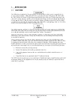
1.3


OVERVIEW

The GPS 10 product is a GPS receiver with WAAS capability, a rechargeable lithium-ion battery, integral
magnetic base and Bluetooth wireless technology capability. Based on the proven technology found in
other Garmin 12-channel GPS receivers, the GPS 10 tracks up to 12 satellites at a time while providing fast
time-to-first-fix, one-second navigation updates, and low power consumption. This generation of GPS
sensors adds the capability of FAA Wide Area Augmentation System (WAAS) differential GPS. The GPS
10’s far-reaching capability meets the sensitivity requirements of land navigation as well as the dynamics
requirements of high-performance aircraft.

The GPS 10 design uses the latest technology and high-level circuit integration to achieve superior
performance while minimizing space and power requirements. All critical components of the system
including the GPS RF/IF receiver hardware and the GPS digital baseband are designed and manufactured
by Garmin to ensure the quality and capability of the GPS. The hardware capability combined with
software intelligence makes the GPS 10 easy to integrate and use for laptop/tablet PC, PDA, and smart
phone applications by incorporating a Class 2 Bluetooth module within the unit.

The GPS 10 product is designed to withstand rugged operating conditions and is waterproof


to IEC 60529

IPX7, immersion in 1 meter of water for 30 minutes. This complete GPS receiver requires no additional
components to be supplied by an OEM or system integrator. An internal rechargeable lithium-ion battery
and 12 VDC charging adapter are provided with the receiver. The only requirement is a clear view of the
GPS satellites. Internal FLASH memory allows the GPS to retain critical data such as satellite orbital
parameters, last-known position, date and time. End user interfaces such as keyboards and displays are the
responsibility of the application designer.

1.4


FEATURES


Integrated Bluetooth

 (Class 2) wireless technology module for communication with a mobile

device.


12-channel GPS receiver tracks and uses up to 12 satellites for fast, accurate positioning and low
power consumption.


Differential DGPS capability using real-time WAAS corrections yielding position errors of less
than 3 meters.


Compact, rugged design ideal for applications with minimal space. Receiver position information
can be displayed directly on a chartplotter or laptop/tablet PC, PDA, or smart phone with
Bluetooth wireless technology capability.


User initialization is not required. Once installed, unit automatically produces navigation data after
position fix is acquired.


User-configurable navigation mode (2-dimensional or 3-dimensional fix).


Configurable for binary format carrier phase data output.


FLASH-based program and non-volatile memory. New software revisions available through Web
site download. Non-volatile memory does not require battery backup.


On-board rechargeable main power battery to maintain the real-time clock


The real-time clock can run for up to 2 months after the main battery enters a low battery mode.


Configurable parameters include expected position, current time and date, preferred position fix
type (2D, 3D, or automatic), and velocity filter time constant (none, automatic, or your choice
between 2 and 255 seconds). 


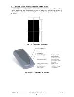
Magnetic mount for attachment to ferrous surfaces. Velcro adhesive backed patch for non-
magnetic surfaces.


Includes 12 VDC Cigarette Lighter Charging Adapter.


Waterproof design allows continuous exposure to the prevailing weather conditions at most
locations.


Auto Power On Mode: When in the Off mode and connected to a switched 12 V DC external
power source, the GPS 10 automatically turns On when external power is turned on. (example: a
cigarette lighter controlled by the vehicle ignition switch.)

Содержание GPS 10 Deluxe

Страница 1: ...Garmin International Inc 1200 E 151st Street Olathe KS 66062 USA 190 00516 00 Revision B February 2005 GPS 10 TECHNICAL SPECIFICATIONS...

Страница 2: ...medium to be viewed and to print one copy of this manual or of any revision hereto provided that such electronic or printed copy of this manual must contain the complete text of this copyright notice...

Страница 3: ...rical Characteristics 6 1 5 5 2 Garmin Interface 6 1 5 5 3 GPS 10 Protocol 6 2 Mechanical Characteristics Mounting 7 3 GPS 10 Software Interface 8 3 1 Received NMEA 0183 Sentences 8 3 1 1 Almanac Info...

Страница 4: ...nfiguration Software 25 Downloading the Sensor Configuration Software 25 Selecting a Model 25 Connecting to the Sensor 25 File Menu 26 Comm Menu 26 Config Menu 26 View Menu 27 Help Menu 27 Appendix E...

Страница 5: ...Operation of this device is subject to the following conditions 1 This device may not cause harmful interference and 2 this device must accept any interference received including interference that ma...

Страница 6: ...BREACH OF WARRANTY To obtain warranty service contact your local Garmin authorized dealer or call Garmin Product Support at one of the numbers listed below for shipping instructions and an RMA trackin...

Страница 7: ...ite orbital parameters last known position date and time End user interfaces such as keyboards and displays are the responsibility of the application designer 1 4 FEATURES Integrated Bluetooth Class 2...

Страница 8: ...System Specification Version 1 1 The supported profile is Serial Profile SSP Accessories provided with the GPS 10 Velcro Mounting Patch Not shown 12 VDC Cigarette Lighter Charging Adapter 010 10412 00...

Страница 9: ...3 Battery Capacity 900 mAHr Charging rate Approx 3 Hrs Operating time Approx 12 Hours with WAAS enabled 1 5 2 4 Battery Charger The included Cigarette Lighter Adapter 320 00187 00 can be used to char...

Страница 10: ...feet 10 meters 1 5 5 2 Garmin Interface Refer to the Garmin Device Interface Specification for specific information about the Garmin Protocol The document is located on the Garmin Web site at http ww...

Страница 11: ...a Velcro patch for mounting on non ferrous surfaces The following drawings show example geometry for mounting hardware in case you wish to design your own custom mount Figure 1 shows the mounting foo...

Страница 12: ...ular configuration parameter All sentences received by the GPS sensor must be terminated with CR LF the ASCII characters for carriage return 0D hexadecimal and line feed 0A hexadecimal The checksum hh...

Страница 13: ...n the current default values Current default values can also be obtained by sending PGRMCE to the GPS sensor PGRMC 1 2 3 4 5 6 7 8 9 10 11 12 13 14 hh CR LF 1 Fix mode A automatic 2 2D exclusively hos...

Страница 14: ...e it is necessary to send the following eight byte data stream to temporarily change the data format to NMEA 0183 Then follow by sending a PGRMC1 sentence that turns off the Binary Phase Output Data f...

Страница 15: ...ence Output by Default Maximum Characters GPRMC 74 GPGGA 82 GPGSA 66 GPGSV 70 PGRME 35 GPGLL 44 GPVTG 42 PGRMV 32 PGRMF 82 PGRMB 40 PGRMT Once per minute 50 Table 1 NMEA 0183 Output Sentence Order and...

Страница 16: ...d will be only 59 seconds long In this case the GPS sensor will not transmit the time of day 0h 0m 0s the zero second for the day from which the leap second is removed GPRMC 235959 A 3851 3650 N 09447...

Страница 17: ...ese fields will be null if unused 3 2 7 Recommended Minimum Specific GPS TRANSIT Data RMC GPRMC 1 2 3 4 5 6 7 8 9 10 11 12 hh CR LF 1 UTC time of position fix hhmmss format 2 Status A Valid position V...

Страница 18: ...itude ddmm mmmm format leading zeros will be transmitted 7 Latitude hemisphere N or S 8 Longitude dddmm mmmm format leading zeros will be transmitted 9 Longitude hemisphere E or W 10 Mode M manual A a...

Страница 19: ...325 0 kHz in 0 5 kHz steps 2 Beacon bit rate 0 25 50 100 or 200 bps 3 Beacon SNR 0 to 31 4 Beacon data quality 0 to 100 5 Distance to beacon reference station in kilometers 6 Beacon receiver communica...

Страница 20: ...e and Erromango Islands 14 BERMUDA 1957 Bermuda Islands 15 BOGOTA OBSERVATORY Colombia 16 CAMPO INCHAUSPE Argentina 17 CANTON ASTRO 1966 Phoenix Islands 10 CAPE CANAVERAL Florida Bahama Islands 19 CAP...

Страница 21: ...AMERICAN 1927 Bahamas excluding San Salvador Island 57 NORTH AMERICAN 1927 Central America Belize Costa Rica El Salvador Guatemala Honduras Nicaragua 58 NORTH AMERICAN 1927 Canal Zone 59 NORTH AMERIC...

Страница 22: ...uth Chile 87 SANTO DOS Espirito Santo Island 88 SAO BRAZ Sao Miguel Santa Maria Islands Azores 89 SAPPER HILL 1943 East Falkland Island 90 SCHWARZECK Namibia 91 SOUTHEAST BASE Porto Santo and Madeira...

Страница 23: ...satellite data information is also enabled when the position record is enabled Records sent over RS232 begin with a delimiter byte 10 hex The second byte identifies the record type 33 hex for a positi...

Страница 24: ...s data for the specified satellite 1 The unit has a differential correction for the specified satellite 2 The unit is using this satellite in the solution This pattern is repeated for all 12 channels...

Страница 25: ...ty meters second alt_vel Altitude velocity meters second msl_hght Mean sea level height meters leap_sec UTC leap seconds grmn_days Garmin days days since December 31 1989 Receiver Measurement Record t...

Страница 26: ...itialize static variables static char in_que 256 static int in_que_ptr 0 static rx_state_type rx_state DAT void add_to_que char data define DLE_BYTE 0x10 define ETX_BYTE 0x03 if rx_state DAT if data D...

Страница 27: ...he Device Manager 3 Go to the hardware tab of the resulting pop up window and click on the Device Manager button 4 Right click on Serial BallPoint Mouse and choose the option to Disable NOT uninstall...

Страница 28: ...rk in the box next to Binary Output Data to change the GPS 10 to Garmin Mode The unit will keep this change in the programming until you change it again in the software Note Selecting Config Switch to...

Страница 29: ...iguration Software SNSRCFG exe is included in the software update download Selecting a Model After opening the program snsrcfg exe the following screen appears Select the radio button next to the type...

Страница 30: ...or Config Menu The Config Configuration Menu allows you configure the sensor as it is connected Sensor Configuration F6 Opens the Sensor Configuration Window shown to the right Many of the fields in t...

Страница 31: ...software Select Update Software and then select the file using the Open dialog box You must locate both the rgn file and the updater exe file Do not attempt to update the GPS 10 software unless Bluet...

Страница 32: ...HOST SYSTEM CONSIDERATIONS PIN Code Some systems may or may not require a PIN Code in order to recognize the GPS 10 The default PIN code for GPS 10 is 1234 When you initially make this connection or...

Страница 33: ......

Страница 34: ...armin com Copyright 2005 Garmin Ltd or its subsidiaries Garmin International Inc 1200 East 151st Street Olathe Kansas 66062 U S A Garmin Europe Ltd Unit 5 The Quadrangle Abbey Park Industrial Estate R...

Отзывы: