


5-18
Pilot’s Guide
190-02488-01 Rev. B
Hazard Awareness
Winds/Temps Aloft
Icing
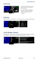
NOTE
Due to the incremental and overlapping nature of the FIS broadcast, timestamps,
regional coverage, and map data availability may vary with altitude for computer
generated FIS-B icing forecasts.
Icing potential is not a forecast, but a presentation of icing potential at the time of
analysis. The icing timestamp shows the valid time in UTC.
Supercooled Large Droplet (SLD) icing conditions are characterized by the presence
of relatively large, super cooled water droplets indicative of freezing drizzle and
freezing rain aloft. SLD threat areas are depicted as black and pink blocks over the
icing colors.
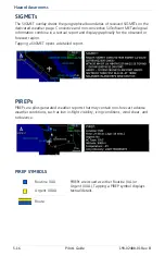
Altitude Range:
2,000 to 24,000 ft (at 2,000 ft intervals)
Not all altitudes provide winds/temps aloft forecasts for all regions.
Indicates wind speed and direction,
and temperature forecast for the
specified altitude.
Altitude range: surface to 45,000 ft
The wind barb extends outward
from the reporting location dot in
the direction of wind origination.
Up and down arrow keys adjust altitude for altitude-based
weather products.
The Icing potential shows a graphic
view of the current icing conditions.
Categories are Trace, Light,
Moderate, and Heavy.
Содержание GNC 355
Страница 1: ...GPS 175 GNC 355 GNX 375 Pilot s Guide...
Страница 102: ...2 68 Pilot s Guide 190 02488 01 Rev B INTENTIONALLY LEFT BLANK...
Страница 252: ...5 48 Pilot s Guide 190 02488 01 Rev B INTENTIONALLY LEFT BLANK...
Страница 253: ...Messages 190 02488 01 Rev B Pilot s Guide 6 1 6 Messages ADVISORY MESSAGES 6 2...
Страница 272: ...6 20 Pilot s Guide 190 02488 01 Rev B INTENTIONALLY LEFT BLANK...
Страница 278: ...7 6 Pilot s Guide 190 02488 01 Rev B INTENTIONALLY LEFT BLANK...
Страница 288: ...9 4 Pilot s Guide 190 02488 01 Rev B INTENTIONALLY LEFT BLANK...
Страница 289: ......
Страница 290: ...190 02488 01 Rev B...