8-7
190-01150-02 Rev. J
Garmin G500H Pilot’s Guide
For
ewor
d
Sec 1
System
Sec 2
PFD
Sec 3
MFD
Sec 4
Hazar
d
Avoidance
Sec 5
Additional
Featur
es
Sec 6
Annun.
& Alerts
Sec 7
Symbols
Sec 8
Glossary
Appendix A
Appendix B
Index
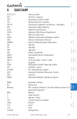
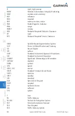
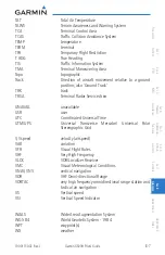
TAT
Total Air Temperature
TAWS
Terrain Awareness and Warning System
TCA
Terminal Control Area
TCAS
Traffic Collision Avoidance System
TEMP temperature
TERM terminal
TFR
Temporary Flight Restriction
T HDG
True Heading
TIS
Traffic Information System
TMA
Terminal Maneuvering Area
Topo topographic
Track
Direction of aircraft movement relative to a ground
position; also ‘Ground Track’
TRK track
TRSA
Terminal Radar Service Area
UNAVAIL unavailable
USR user
UTC
Coordinated Universal Time
UTM/UPS
Universal Transverse Mercator/ Universal Polar
Stereographic Grid
V, Vspeed
velocity (airspeed)
VAR variation
VFR
Visual Flight Rules
VHF
Very High Frequency
VLOC
VOR/Localizer Receiver
VMC
Visual Meteorological Conditions
VNAV, VNV
vertical navigation
VOR
VHF Omni-directional Range
VORTAC
very high frequency omnidirectional range station and
tactical air navigation
VS
Vertical speed
VSI
Vertical Speed Indicator
WAAS
Wide Area Augmentation System
WGS-84
World Geodetic System - 1984
WPT waypoint(s)
WX weather
Содержание G500H
Страница 1: ...G500H Pilot s Guide ...
Страница 365: ......

