4-4
Garmin G500H Pilot’s Guide
190-01150-02 Rev. J
For
ewor
d
Sec 1 System
Sec 2
PFD
Sec 3
MFD
Sec 4
Hazar
d
Avoidance
Sec 5
Additional Featur
es
Sec 6
Annun. & Alerts
Sec 7
Symbols
Sec 8
Glossary
Appendix A
Appendix B
Index
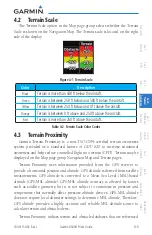
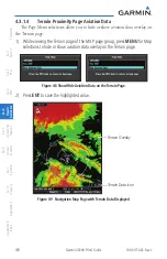
to mean sea level (MSL). Using the GPS position and GPS-MSL altitude, Terrain
Proximity displays a 2-D picture of the surrounding terrain and obstacles relative
to the position and altitude of the aircraft. In this manner, Terrain Proximity
provides awareness of surrounding terrain conditions.
Terrain-Proximity - is a non-TSO-C194 certified terrain awareness system. Do
not confuse Terrain Proximity with H-TAWS. H-TAWS is TSO-C194 certified and
Terrain Proximity is not. Terrain Proximity does not provide warning annunciations
or voice alerts, it only provides color indications on map displays when terrain and
obstacles are within a certain altitude threshold from the aircraft.
Terrain-HSVT is a non-TSO-C194 certified terrain awareness system. Do
not confuse Terrain-HSVT with H-TAWS. H-TAWS is TSO-C194 certified
and Terrain-HSVT is not. Terrain-HSVT provides terrain alerting functionality,
including visual alerting and aural alerting. Terrain-HSVT is provided with the
Synthetic Vision functionality and not marketed separately. Garmin Terrain-
HSVT is available in GDU 620 v4.00 or later, when configured for Rotary Wing
and Synthetic Vision enabled.
Terrain Proximity requires the following to operate properly:
• The system must have a valid 3-D GPS position solution.
• The system must have a valid terrain/obstacle database.
Содержание G500H
Страница 1: ...G500H Pilot s Guide ...
Страница 365: ......

