background image

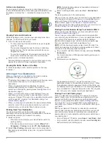
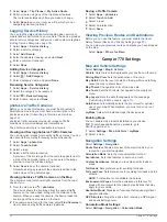
The destination indicator 

À

 shows the direction of your 

destination relative to the direction you are moving 

Á

. When 

the destination indicator appears at the top of the circle, you 

are heading toward your destination. The remaining distance 

to your destination 

Â

 appears below the circle. The progress 

bar 

Ã

 shows your progress toward your destination.

Changing Your Active Route

Adding a Location to Your Route

Before you can add a location to your route, you must be 

navigating a route (

Starting a Route

, page 3

).

You can add locations to the middle or end of your route. For 

example, you can add a fuel station as the next destination in 

your route.

TIP: 

To create complex routes with multiple destinations or 

scheduled stops, you can use the trip planner to plan, schedule, 

and save a trip (

Planning a Trip

, page 17

).

1

From the map, select   > 

Where To?

.

2

Search for a location (

Finding and Saving Locations

page 6

).

3

Select a location.

4

Select 

Go!

.

5

Select an option:
• To add the location as the next destination in your route, 

select 

Add As Next Stop

.

• To add the location to the end of your route, select 

Add 

As Last Stop

.

• To add the location and edit the order of destinations in 

your route, select 

Add to Active Route

.

The device re-calculates the route to include the added location 

and guides you to the destinations in order.

Shaping Your Route

Before you can shape your route, you must start a route 

(

Starting a Route

, page 3

).

You can manually shape your route to change its course. This 

allows you to direct the route to use a certain road or go through 

a certain area without adding a destination to the route.

1

Touch anywhere on the map.

2

Select  .
The device enters route shaping mode.

3

Select a location on the map.

TIP: 

You can select   to zoom in on the map and select a 

more precise location.
The device recalculates the route to travel through the 

selected location.

4

If necessary, select an option:
• To add more shaping points to the route, select additional 

locations on the map.

• To remove a shaping point, select  .

5

When you are finished shaping the route, select 

Go!

.

Taking a Detour

You can take a detour for a specified distance along your route 

or detour around specific roads. This is useful if you encounter 

construction zones, closed roads, or poor road conditions.

1

From the map, select   > 

Change Route

.

TIP: 

If the Change Route tool is not in the map tools menu, 

you can add it (

Enabling Map Tools

, page 10

).

2

Select an option:
• To detour your route for a specific distance, select 

Detour 

by Distance

.

• To detour around a specific road on the route, select 

Detour by Road

.

• To find a new route, select 

Detour

.

Changing the Route Calculation Mode

1

Select 

Settings

 > 

Navigation

 > 

Calculation Mode

.

2

Select an option:
• Select 

Faster Time

 to calculate routes that are faster to 

drive but can be longer in distance.

• Select 

Off Road

 to calculate point-to-point routes (without 

roads).

• Select 

Shorter Distance

 to calculate routes that are 

shorter in distance but can take more time to drive.

Stopping the Route

From the map, select   > 

Stop

.

Using Suggested Routes

Before you can use this feature, you must save at least one 

location and enable the travel history feature (

Device and 

Privacy Settings

, page 20

).

Using the myTrends

 feature, your device predicts your 

destination based on your travel history, the day of the week, 

and the time of day. After you have driven to a saved location 

several times, the location may appear in the navigation bar on 

the map, along with the estimated time of travel, and traffic 

information.

Select the navigation bar to view a suggested route to the 

location.

Avoiding Delays, Tolls, and Areas

Avoiding Traffic Delays on Your Route

Before you can avoid traffic delays, you must be receiving traffic 

information (

Receiving Traffic Data Using Smartphone Link

page 14

).

By default, the device optimizes your route to avoid traffic delays 

automatically. If you have disabled this option in the traffic 

settings (

Traffic Settings

, page 19

), you can view and avoid 

traffic delays manually.

1

While navigating a route, select   > 

Traffic

.

2

Select 

Alternate Route

, if available.

3

Select 

Go!

.

Avoiding Toll Roads

Your device can avoid routing you through areas that require 

tolls, such as toll roads, toll bridges, or congestion areas. The 

device may still include a toll area in your route if no other 

reasonable routes are available.

1

Select 

Settings

 > 

Navigation

.

2

Select an option:

NOTE: 

The menu changes based on your area and the map 

data on your device.
• Select 

Toll Roads

.

• Select 

Tolls and Fees

 > 

Toll Roads

.

Navigating to Your Destination

5

Содержание Camper 770

Страница 1: ...CAMPER770 Owner sManual ...

Страница 2: ...ademarks of Garmin Ltd or its subsidiaries These trademarks may not be used without the express permission of Garmin Android is a trademark of Google Inc Apple and Mac are trademarks of Apple Inc registered in the U S and other countries The Bluetooth word mark and logos are owned by the Bluetooth SIG Inc and any use of such word mark or logo by Garmin is under license Foursquare is a trademark of...

Страница 3: ...arch Tools 8 Finding an Address 8 Finding an Intersection 8 Finding a City 8 Finding a Location Using Coordinates 8 Foursquare 8 Connecting to Your Foursquare Account 8 Searching Foursquare Points of Interest 8 Viewing Foursquare Location Details 8 Checking in with Foursquare 9 TripAdvisor 9 Finding TripAdvisor Points of Interest 9 Viewing Recently Found Locations 9 Clearing the List of Recently F...

Страница 4: ...iewing Previous Routes and Destinations 18 Camper 770 Settings 18 Map and Vehicle Settings 18 Enabling Maps 18 Navigation Settings 18 Calculation Mode Settings 18 Setting a Simulated Location 19 Wireless Network Settings 19 Driver Assistance Settings 19 Backup Camera Settings 19 babyCam Settings 19 Display Settings 19 Traffic Settings 19 Units and Time Settings 19 Setting the Time 19 Language and ...

Страница 5: ...y before the prompt appears the device enters power saving mode Acquiring GPS Signals When you turn on your navigation device the GPS receiver must collect satellite data and establish the current location The time required to acquire satellite signals varies based on several factors including how far you are from the location where you last used your navigation device whether you have a clear vie...

Страница 6: ...ivating a Vehicle Profile Before you can activate a vehicle profile you must add the profile 1 Select Settings Vehicle Profile 2 Select a vehicle profile The vehicle profile information appears including measurements and weight 3 Select Select Editing a Vehicle Profile You can change basic vehicle profile information or add detailed information to a vehicle profile such as maximum speed 1 Select S...

Страница 7: ...mize the route Shaping Your Route page 5 You can add multiple destinations to a route Adding a Location to Your Route page 5 Starting a Route 1 Select Where To and search for a location Finding and Saving Locations page 6 2 Select a location 3 Select an option To start navigating using the recommended route select Go To choose an alternate route select and select a route Alternate routes appear to...

Страница 8: ... Detailed parking data is not available in all areas or for all parking locations 3 Select a parking location and select Go Add As Next Stop The device guides you to the parking area After you park your vehicle you can continue to your destination on foot using your Camper 770 device or a compatible Garmin watch with Connect IQ Finding Your Destination Using Your Garmin Watch page 4 Your device or...

Страница 9: ... specific roads This is useful if you encounter construction zones closed roads or poor road conditions 1 From the map select Change Route TIP If the Change Route tool is not in the map tools menu you can add it Enabling Map Tools page 10 2 Select an option To detour your route for a specific distance select Detour by Distance To detour around a specific road on the route select Detour by Road To ...

Страница 10: ... Settings Navigation Custom Avoidances 2 Select an avoidance 3 Select Disable Deleting Custom Avoidances 1 Select Settings Navigation Custom Avoidances 2 Select an option To delete all custom avoidances select To delete one custom avoidance select the avoidance and select Delete Navigating Off Road If you are not following roadways as you navigate you can use Off Road mode 1 Select Settings Naviga...

Страница 11: ...e location of the POI within the venue Exploring a Venue You can view a list of all points of interest located within each venue 1 Select a venue 2 Select Explore this Venue Finding RV Parks NOTE This feature is not available in all areas You can search for RV parks based on the amenities available 1 Select Where To RV Parks 2 If necessary select Filter by Amenities select one or more amenities an...

Страница 12: ...ss Finding an Intersection You can search for an intersection or junction between two streets highways or other roads 1 Select Where To Categories Intersections 2 Follow the on screen instructions to enter street information 3 Select the intersection Finding a City 1 Select Where To Categories Cities 2 Select an option Select a city from the list of nearby cities To search near another location se...

Страница 13: ...f you need to tell another person how to get to your current location your device can give you a list of directions 1 From the map select the vehicle 2 Select Directions to Me 3 Select a starting location 4 Select Select Adding a Shortcut You can add shortcuts to the Where To menu A shortcut can point to a location a category or a search tool The Where To menu can contain up to 36 shortcut icons 1...

Страница 14: ... to the menu 1 From the map select 2 Select the check box next to each tool to add 3 Select Save Up Ahead The Up Ahead tool provides information about upcoming locations along your route or the road on which you are traveling You can view upcoming points of interest such as restaurants fuel stations or rest areas When traveling on a highway you can also view information and available services for ...

Страница 15: ...available Parking page 8 Garmin Live Services Provides free and paid services to send live data to your device such as red light and speed cameras or traffic cameras Garmin Live Services page 12 Weather information Sends real time weather conditions and alerts to your device Viewing the Weather Forecast page 17 LiveTrack Allows you to share your trip with selected contacts in real time LiveTrack p...

Страница 16: ...ur Camper 770 device Smart Notifications While your device is connected to the Smartphone Link app you can view notifications from your smartphone on your Camper 770 device such as text messages incoming calls and calendar appointments NOTE You may need to wait a few minutes to receive notifications on your navigation device after it connects to the Smartphone Link app appears colored in the Bluet...

Страница 17: ... you save a home number you can edit the home number by editing Home in your list of saved locations Editing a Saved Location page 9 1 Select Apps Phone Set Home Number 2 Enter your phone number 3 Select Done Calling Home Before you can call home you must enter a phone number for your home location Select Apps Phone Call Home Setting Up Bluetooth Features for Your Apple Device By default all compa...

Страница 18: ...of the traffic information Your device can provide information about traffic on the road ahead or on your route You can set your device to avoid traffic when calculating routes and to find a new route to your destination if a large traffic delay occurs on your active route Traffic Settings page 19 The traffic map allows you to browse the map for traffic delays in your area To provide traffic infor...

Страница 19: ...hrase 3 Select Done Activating Voice Command Say your wakeup phrase The voice command menu appears Voice Command Tips Speak in a normal voice directed at the device Reduce background noise such as voices or the radio to increase the accuracy of the voice recognition Speak commands as they appear on the screen Respond to voice prompts from the device as needed Increase the length of your wakeup phr...

Страница 20: ...h Link app and select Driver Warnings While you are navigating with your Camper 770 device the watch vibrates and displays the specified driver alerts as they occur LiveTrack NOTICE Use caution when sharing your location information with others The LiveTrack feature lets you share your trip with contacts from your smartphone and your social networking accounts such as Facebook and Twitter While yo...

Страница 21: ...lude at least a starting location and one destination The starting location is the location from which you plan to start your trip If you start navigating the trip from a different location the device gives you the option to route to your starting location first For a round trip the starting location and final destination can be the same 1 Select Apps Trip Planner New Trip 2 Select Select Start Lo...

Страница 22: ...mera When you pass the camera the device loads the live image of the next camera on the road 2 If no cameras are found for the road select Find Cameras to view or save nearby traffic cameras optional Saving a Traffic Camera 1 Select Apps photoLive 2 Select Touch to Add 3 Select a road 4 Select an intersection 5 Select Save Viewing Previous Routes and Destinations Before you can use this feature yo...

Страница 23: ...urchase a Garmin backup camera Select Settings Backup Camera and select a paired camera Unpair Removes the paired camera You must pair the camera again before you can view it using this device and cable Rename Allows you to rename the paired camera Guidance Lines Shows or hides guidance lines and allows you to adjust the position of the guidance lines babyCam Settings The babyCam settings allow yo...

Страница 24: ...me and office use only Battery type Rechargeable lithium ion Charging the Device NOTE This Class III product shall be powered by an LPS power supply You can charge the battery in the device using any of these methods Connect the device to vehicle power Connect the device to an optional power adapter accessory such as a wall power adapter You can purchase an approved Garmin AC DC adapter suitable f...

Страница 25: ...ct an option To install on a Windows computer select Download for Windows To install on a Mac computer select Download for Mac 3 Open the downloaded file and follow the on screen instructions to complete the installation 4 Start Garmin Express 5 Connect your Camper 770 device to your computer using a USB cable 6 On your computer click Add a Device The Garmin Express software detects your device 7 ...

Страница 26: ... vehicle Check the fuse in the vehicle power cable Changing the Fuse in the Vehicle Power Cable page 22 Verify the vehicle is turned on and is supplying power to the power outlet Verify the interior temperature of the vehicle is within the charging temperature range indicated in the specifications Verify the fuse is not broken in the vehicle power outlet My battery does not stay charged for very l...

Страница 27: ... Your Computer You can connect the device to your computer using a USB cable 1 Plug the small end of the USB cable into the port on the device 2 Plug the larger end of the USB cable into a port on your computer A picture of your device connected to a computer appears on the device screen Depending on your computer operating system the device appears as either a portable device a removable drive or...

Страница 28: ...er 13 I icons status bar 1 ID number 20 intersections finding 8 K keyboard language 20 layout 20 L language keyboard 20 voice 20 latitude and longitude 8 LiveTrack 16 location 8 locations 8 18 calling 13 current 9 recently found 9 saving 9 searching for 6 8 simulated 19 venues 7 M map layers customizing 11 map view 2 D 11 3 D 11 maps 3 10 18 data field 3 10 11 detail level 18 layers 11 purchasing ...

Страница 29: ...15 receiver 14 searching for delays 11 15 traffic cameras viewing 18 travel history 20 trip information 10 resetting 10 viewing 10 trip log viewing 10 trip planner 17 editing a trip 17 shaping points 17 TripAdvisor 9 troubleshooting 22 turn list 4 U unit ID 20 up ahead 10 customizing 10 updating maps 20 21 software 20 21 USB disconnecting 23 V vehicle power cable 1 vehicle profile camper 2 venues ...

Страница 30: ... 55 69 33 99 39 02 36 699699 52 001 855 792 7671 0800 427 652 0800 0233937 47 815 69 555 00800 4412 454 44 2380 662 915 35 1214 447 460 386 4 27 92 500 0861 GARMIN 427 646 27 0 11 251 9800 34 93 275 44 97 46 7744 52020 886 2 2642 9199 ext 2 0808 238 0000 44 870 850 1242 49 0 89 858364880 zum Ortstarif Mobilfunk kann abweichen 913 397 8200 1 800 800 1020 February 2017 190 02193 00_0A ...

Отзывы:

Похожие инструкции для Camper 770