9. ROUTES
9-5
9.4.1
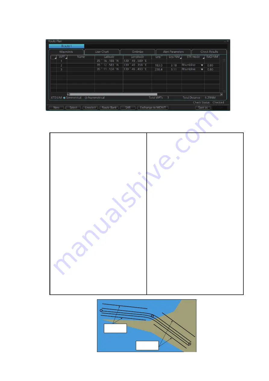
How to use the Waypoints page
The following fields and boxes can be found in the [Waypoints] page. Scroll the list
rightward to see hidden items.
WPT
: Each waypoint has a number.
Name
: You can name each waypoint.
Latitude
: WPTs latitude coordinate is dis-
played in WGS-84 datum.
Longitude
: WPTs longitude coordinate is
displayed in WGS-84 datum.
Leg/
°: Bearing of leg (True: reference to
North). The bearing of legs can be changed.
Right click a bearing to show the context
sensitive menu. Select [Adjust Position],
then set bearing in the pop-up window.
Leg/NM
: Length of leg (nm). The display
method can changed by right clicking the
column title to show the context sensitive
menu. [Each] shows the distance of each
leg. [Total] shows the total cumulative dis-
tance from leg to leg. [Remain] shows the
distance remaining from leg to leg. Note that
these settings are reflected to [Leg/NM] in
the [Waypoints] page of the [Monitor Infor-
mation] dialog box.
Str Mode
: Define steering mode for each
leg - rhumb line or great circle. Click to select
[Rhumbline] or [Greatcircle].
RAD/NM
: Define turning radius for each
waypoint. To change a radius, put the cursor
in this column to show up and down arrows.
Click the arrows to set the radius.
XTD LIM/m
: The radio button [XTD LIM] de-
termines how to set the channel limits. The
[Symmetrical] setting shows [XTD LIM/m] in
the setting window, indicating that the port
and starboard channel limits are equal.
[Asymmetrical] replaces [XTD LIM/m] with
[XTD Port/m] and [XTD Starboard/m], allow-
ing individual setting of port and starboard
channel limits.
Plan SPD
: Define planned speed to use with
a leg.
SPD Max
: Define maximum speed to use
with a leg.
Margin/m
: Define extension for channel lim-
its to be checked against chart alerts.
PL 1/m, PL 2/m
: One or two sets of parallel
lines, colored orange, can be drawn on a
route. Set the distance (in meters) to offset
the lines from the route, from -99999 to
99999. Parallel lines allow the navigator to
maintain a given distance away from haz-
ards. See the illustration below.
XTD LIM
(radio button): Selects how to set
channel limits - port and starboard channel
limits are equal or not equal
Local Time
:
Use local time. Enter the time
difference between UTC and local time.
WPT2
WPT1
WPT3
Parallel Line for
Leg 1
Parallel Line for
Leg 2
Содержание FMD3100
Страница 1: ...www furuno com OPERATOR S MANUAL Model FMD 3100 ELECTRONIC CHART DISPLAY AND INFORMATION SYSTEM ECDIS ...
Страница 36: ...1 INTRODUCTION 1 20 This page is intentionally left blank ...
Страница 70: ...2 OPERATIONAL OVERVIEW 2 34 This page is intentionally left blank ...
Страница 128: ...5 VECTOR S57 CHARTS 5 12 This page is intentionally left blank ...
Страница 140: ...7 C MAP BY JEPESSEN CHARTS 7 6 This page is intentionally left blank ...
Страница 206: ...11 HOW TO MONITOR ROUTES 11 16 This page is intentionally left blank ...
Страница 230: ...13 TRACKED TARGET TT FUNCTIONS 13 10 This page is intentionally left blank ...
Страница 244: ...14 AIS TARGET FUNCTIONS 14 14 This page is intentionally left blank ...
Страница 250: ...15 AIS SAFETY NAVTEX MESSAGES 15 6 This page is intentionally left blank ...
Страница 294: ...19 RECORDING FUNCTIONS PLAYBACK FUNCTIONS 19 14 This page is intentionally left blank ...
Страница 312: ...20 ALERTS 20 18 This page is intentionally left blank ...
Страница 332: ...22 SETTINGS MENU 22 16 This page is intentionally left blank ...
Страница 338: ...23 MAINTENANCE AND TROUBLESHOOTING 23 6 This page is intentionally left blank ...
Страница 395: ......


