700-SDI-RADAR-300W-Man Rev 2 30 May 2022
5
/39
Part# 21370
INSTALLATION
3.1
INSTALLATION POSITION
The flow meter must be installed above the water surface, pointing toward the water surface at a
vertical angle. Recommended minimum height above the water surface is 1 meter, with maximum
height up to 20 meters. Recommended vertical angle is 45 degrees. See Figure 3-1 for diagram and
Imperial units.
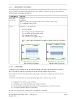
When selecting the installation location additional care must be taken to avoid reflected power away
from the radar (red arrow) to hit moving objects (gray cloud) on the side of the water channel as this
can cause additional inbound reflection to the radar and can significantly affect measurement
accuracy (refer to Figure 3-2). Installations where pedestrians, cars or other objects are moving in
front of the sensor closer than 75 m should be avoided as it is proven in practice that it can cause
problems.
To achieve the specified accuracy, it is important to properly select measurement site and to install
sensor with proper horizontal and vertical tilt angle. The tilt angle to horizontal plane for surface
velocity sensor should be between 30° and 60°, and if instrument is mounted with reasonable
tolerances to the pole this should be maintained. The instrument should be oriented in parallel
with the water flow direction. For optimal operation, and best results. Any deviation from parallel
water flow direction will introduce offset of the real measurement value, more precise value will
be lower than actual surface velocity of the water. It is recommended that the instrument is
pointed upstream, so that the water flows towards the instrument.The height of the instrument
above the water surface and the inclination determine area on the surface that is covered by
the radar beam. This measurement area should be clear of any obstacles. The structure holding
the instrument (pole, bridge fence, etc.) must be solid and without vibrations. There should be
no vegetation between the radar and the measurement area because it could affect measurement
accuracy.
The water surface direct below the sensor should be clean of vegetation, rocks, sand
deposition or other obstacles that could affect measurement.
Surface velocity radar beam will cover an elliptical area on the water surface. The radar reports
average surface velocity of the covered area and instrument uses complex Kalman filters with
physical modelling of the water flow to give stable measurements even under turbulent conditions.
However even the moderate waviness of the water surface will improve the measurement, if the
water flow is strongly turbulent, fluctuations in measured data could be expected as well as
somewhat reduced measurement accuracy. If strongly turbulent flow can be expected at
monitoring site, then the filter length of the radar should be configured to 120 or more.
Additional information can be found at:
https://geolux.ams3.cdn.digitaloceanspaces.com/documents/Surface-Velocity-Measurement.pdf


