background image


SHANGHAI ESURVEY GNSS CO., LTD

40 

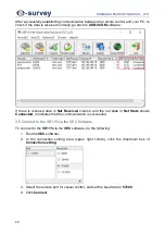
After successfully establishing communication between the remote control and your PC, to 
check if the data is received normally, go back to 

USR-VCOM

 software: 


If  there  is  received  data  in 

Net  Received

  column,  and  the  net  state  in 

Net  State

  shows 

Connected

, it indicates that the communication is successful. 

3.5 Connect to the VE115 via the VEC Software 

To connect to the 

VE115

 via the 

VEC

 software, do the following: 

1.  Run the 

VEC

 software. 

2.  In  the  connection  setting  area  (upper  right  corner),  click  the  dropdown  box  of 

Connection setting


3.  Select the remote port for vessel control, and set the baud rate to 

57600

4.  Click 

Connect


Содержание VE115

Страница 1: ...Shanghai eSurvey GNSS Co Ltd 1st Edition V1 0 Unmanned Vessel Control System USER GUIDE VE115...

Страница 2: ......

Страница 3: ...cument are the property of their respective holders Notice The purchased products services and features are stipulated by the contract made between eSurvey and the customer All or part of the products...

Страница 4: ...SHANGHAI ESURVEY GNSS CO LTD...

Страница 5: ...are 25 3 Quick Start 34 3 1 Assemble the VE115 35 3 2 Modify the Local IP Address 36 3 3 Set the Virtual Serial Port 38 3 4 Establish Communication between the Remote Control and Your PC 39 3 5 Connec...

Страница 6: ...SHANGHAI ESURVEY GNSS CO LTD II...

Страница 7: ...er guide is subject to change without notice We reserve the right to change or improve the device as well the content in the user guide without any obligation to notify you For any questions please co...

Страница 8: ...es are tightly connected before using the system to prevent the equipment from shaking and falling Data Please be careful when deleting data because this operation is permanent and you cannot undo the...

Страница 9: ...charging please turn on the power and unplug the propeller connector After finishing your surveying works please fully charge the battery before storing it It is forbidden to charge at night and unatt...

Страница 10: ...ditions of the operator including alcohol drugs drug anesthesia dizziness weakness nausea and other physical or mental conditions Personal injuries or property loss caused by the operator s subjective...

Страница 11: ...llision capsizing fire explosion lightning storm tornado heavy rain flood tsunami land subsidence ice subsidence avalanche hailstorm mudslide landslide earthquake etc Damage caused by using unauthoriz...

Страница 12: ...e video and wireless transmission technology With the advanced route planning algorithm VE115 can help automatically realize autonomous navigation surveys according to the planned route VE115 consists...

Страница 13: ...tage is not lower than 24 V after each operation Otherwise the battery may be scrapped 10 Propeller 2 1 2 Remote Control The remote control is a radio communication device with 2 4GHz band Its maximum...

Страница 14: ...trol the vessel Switch for navigation light to turn on off the navigation light for working at night o When the lever is at the top it indicates that is navigation is off o When the lever is at the bo...

Страница 15: ...are 2 2 1 USR VCOM software The USR VCOM software is mainly used to set the virtual serial ports for the vessel control GNSS receiver and echosounder 2 2 1 1 Installation To install USR VCOM software...

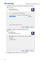
Страница 16: ...SHANGHAI ESURVEY GNSS CO LTD 10 2 Select English and click Next 3 Click Next...

Страница 17: ...SHANGHAI ESURVEY GNSS CO LTD 11 4 Select I agree to the terms of this license agreement and click Next 5 Input user information and click Next...

Страница 18: ...S CO LTD 12 6 Select the target installation path to install the software and click Next 7 Select the shortcut folder select Install shortcuts for current user only or Make shortcuts available to all...

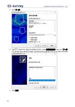
Страница 19: ...SHANGHAI ESURVEY GNSS CO LTD 13 8 Click Next The software automatically starts to install After installing the following dialog box shows 9 Click Finish...

Страница 20: ...ils 2 2 2 VEC Software The VEC software is used to control the vessel monitor the vessel status monitor the remote video and do planning 2 2 2 1 Installation Before installing the VEC software insert...

Страница 21: ...GNSS CO LTD 15 2 2 2 2 Main Interface The VEC software is user friendly and easy to use It mainly contains the following pages Mission page Setting page 2 2 2 2 1 Mission Page The Mission page is as...

Страница 22: ...oints according to the sailing track o Name What it does Write To save the planned waypoints and sailing routes to the vessel control unit Read To read waypoints and sailing routes stored in the vesse...

Страница 23: ...ing o if you select Sampling set the following 2 RTL area to select a way of making the vessel automatically return o straight line default CAUTION Please be careful when there is an obstacle in a str...

Страница 24: ...ime monitoring o to clear the sailing track in the map area o to load the sailing track saved before 6 Keys area to enable or disable obstacle avoidance CAUTION Please disable obstacle avoidance befor...

Страница 25: ...manual free no connection with the vessel control unit and auto the vessel is in automatic mode See Remote Control for details o Un Armed the current status of the remote control including armed lock...

Страница 26: ...SHANGHAI ESURVEY GNSS CO LTD 20 2 2 2 2 2 Setting Page The Setting page is as shown as follows...

Страница 27: ...rea you can do the following Select a software language English and Select a map provider AMap AMapSatellite GoogleMap GoogleSatelliteMap GoogleHybridMap GoogleChinaMap GoogleChinaSatelliteMap and Goo...

Страница 28: ...o network To select WLAN click LAN and Set and set the following To select LAN click WLAN and Set and set the following Select whether to automatically save the sailing tracks Export import a license...

Страница 29: ...e obstacle avoidance system please set it to Hold Obstacle underwater not available for VE115 Run Get to read parameters from the vessel when the vessel is connected Set to apply settings when paramet...

Страница 30: ...ing route and RTL backtracking FailSafeInfo to show the information about alerts and warnings 2 Remote control to observe the feedback information of control unit input and servo output so as to judge...

Страница 31: ...is mainly used for data collection design survey data processing of GNSS data and echosounder etc 2 2 3 1 Installation Before installing the Navigator software do the following 1 Insert the navigator...

Страница 32: ...SHANGHAI ESURVEY GNSS CO LTD 26 3 Click 4 Click select the target installation path check and click The dongle driver starts to install and the following dialog box pops up after installing 5 Click...

Страница 33: ...URVEY GNSS CO LTD 27 To install the Navigator software do the following 1 Double click program Select Setup Language dialog box pops up 2 Select English and click OK The navigator setup wizard dialog...

Страница 34: ...I ESURVEY GNSS CO LTD 28 3 Click Next The dialog box of selecting the installation path pops up 4 Click Next The dialog box of additional tasks pops up 5 Click Next and select whether to create deskto...

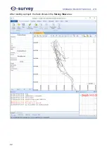
Страница 35: ...lation start After finish installation the following dialog box pops up 7 Click Finish The main interface of eSurvey data collection software shows and New Open Project dialog box shows About how to l...

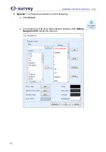
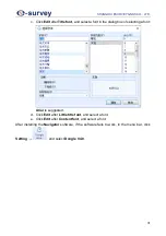
Страница 36: ...ANGHAI ESURVEY GNSS CO LTD 30 8 Optional To change the default font do the following a Click Cancel b In the menu bar of eSurvey data collection software click Setting Navigation Info dialog box pops...

Страница 37: ...the dialog box of selecting a font Arial is suggested d Click Edit after Little title font and select a font e Click Edit after Content font and select a font After installing the Navigator software...

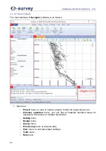
Страница 38: ...ect menu to load or create a project modify the target project etc o Common operation menu you can find all detailed operation steps for operations in this menu in chapter Quick Start o Setting menu o...

Страница 39: ...2 Navigation information device monitoring GNSS receiver and echosounder GPS skyplot bar 3 View area including survey view and tide station view 4 Messages GPS yaw stakeout info bar 5 Depth line to v...

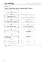
Страница 40: ...SHANGHAI ESURVEY GNSS CO LTD 34 3 Quick Start The basic process of quickly starting your surveying work is as follows NOTE The operation in Italic is optional...

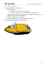
Страница 41: ...der unit b Connect the charge cable to the charge interface on the battery unit When the value of voltage is greater than 33V unplug the charge cable and assemble the cover of the echosounder unit 2 I...

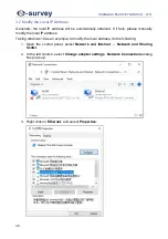
Страница 42: ...lease manually modify the local IP address Taking windows 10 as an example to modify the local address do the following 1 Open the control panel select Network and Internet Network and Sharing Center...

Страница 43: ...ANGHAI ESURVEY GNSS CO LTD 37 4 Click Properties 5 Select Use the following IP address set the following and click OK o IP address 192 168 1 XX o Subnet mask 255 255 255 0 o Default gateway 192 168 1...

Страница 44: ...al port for vessel control GNSS receiver and echosounder NOTE You can freely choose the serial port number for both 2 4G network and 4G network as long as the serial port is not occupied It is recomme...

Страница 45: ...lowing If you use 2 4G network do the following a Turn on the remote control b To turn on the hotspot of the remote control slide your finger down on the screen and press c Connect your PC to the Wi F...

Страница 46: ...ved column and the net state in Net State shows Connected it indicates that the communication is successful 3 5 Connect to the VE115 via the VEC Software To connect to the VE115 via the VEC software d...

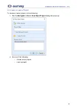
Страница 47: ...NSS CO LTD 41 3 6 Create or Load a Project To create or load a project do the following 1 Run the Navigator software New Open Project dialog box pops up 2 Do one of the following o Create a new projec...

Страница 48: ...SHANGHAI ESURVEY GNSS CO LTD 42 After loading a project the track shows in the Survey View area...

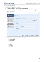
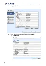
Страница 49: ...lowing 1 In New Open Project dialog box select New Project 2 In the input box Project Name input a project name and click OK Project wizard dialog box pops up 3 In Basic page set the following basic i...

Страница 50: ...SHANGHAI ESURVEY GNSS CO LTD 44 4 In Coord page do the following a To set a template of the coordinate system do the following i Click Template...

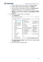
Страница 51: ...Central Meridian Format dd mmss e g for 113 9 3 please input 113 0903 v Optional To correct the X coordinate and Y coordinate separately input the correction value into input boxes of False Easting a...

Страница 52: ...SHANGHAI ESURVEY GNSS CO LTD 46 c To convert parameters do the following i Click Geo Calculator ii Covert parameters...

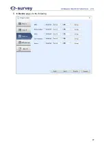
Страница 53: ...SHANGHAI ESURVEY GNSS CO LTD 47 5 In Device page do the following...

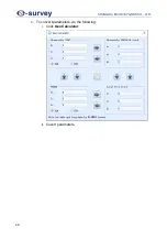
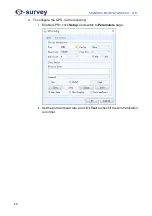
Страница 54: ...AI ESURVEY GNSS CO LTD 48 a To configure the GPS do the following i Enable GPS1 click Setup and switch to Parameters page ii Set the port and baud rate and click Test to check if the communication is...

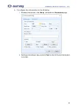
Страница 55: ...EY GNSS CO LTD 49 b To configure the echosounder do the following i Enable echosounder click Setup and switch to Parameters page ii Set the port and baud rate and click Test to check if the communicat...

Страница 56: ...and RTK b Select the collection type and set the interval Time interval coordinate data and depth data will be collected after the specified time Distance interval coordinate data and depth data will...

Страница 57: ...r pole is 0 406 m the bottom of the GNSS receiver to the phase center is 0 04 m and the swirl marks at the top of the GNSS receiver pole is 0 02 m b Click Finish 3 6 2 Load a Project To load a project...

Страница 58: ...lick the target position on the map o Manually input longitude and latitude of the target waypoint The sailing route automatically shows on the map according to the drawn waypoint order 3 Optional To...

Страница 59: ...ning dialog box set the following o Space the space among each sailing route o Angle o Start point the start position of your mission You can select among home left top left bottom right top and right...

Страница 60: ...5 make sure each switch of the remote control is in the following states The propeller control rocker is in the original state The lever of the switch for locking unlocking is in the middle or at the...

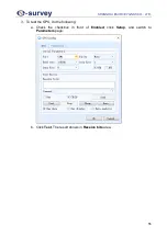
Страница 61: ...SHANGHAI ESURVEY GNSS CO LTD 55 3 To test the GPS do the following a Check the checkbox in front of Enabled click Setup and switch to Parameters page b Click Test The result shows in Receive bits area...

Страница 62: ...SHANGHAI ESURVEY GNSS CO LTD 56 4 To test the echosounder do the following a Check the checkbox in front of Enabled click Setup and switch to Parameters page...

Страница 63: ...t The result is as follows 5 Push the propeller control rocker of the VE115 and check if the motor of the vessel works normally by hearing the sound of the motor After making sure that the VE115 can w...

Страница 64: ...start your surveying works do one of the following o If you select automatic route planning click in the lower right of VEC software The vessel automatically starts surveying and returns to the set re...

Страница 65: ...SHANGHAI ESURVEY GNSS CO LTD 59 To process data do the following 1 In the menu bar do one of the following o Click Common Operation o Click Processing Single Beam Editor dialog box pops up...

Страница 66: ...SHANGHAI ESURVEY GNSS CO LTD 60 2 To open a depth file do one of the following o Click File Open o Click Survey Lines dialog box pops up NOTE and are not available for unmanned surface vessels...

Страница 67: ...on the left o To scale down the view of water depth click or click View Zoom Out V The smaller the display scale the larger the scale range on the left o To enlarge the display range of the water dept...

Страница 68: ...elected c To select a sampling method select one of the following and input a value in input box Sample interval Time the software takes a depth value at the set interval time and estimates the coordi...

Страница 69: ...l Moving Surface Line hold down the left mouse button and drag the elevation line to the target position When the elevation of water surface is between 0 m and 9 9 m the scale where the elevation line...

Страница 70: ...SHANGHAI ESURVEY GNSS CO LTD 64 3 11 Export Files To export files do the following 1 In the menu bar do one of the following o Click Common Operation o Click Processing File Export dialog box pops up...

Страница 71: ...dd d After adding all your required formats click OK 3 Select the target format in the dropdown box of Format 4 Optional To modify the customized format click Edit and make the modification NOTE Only...

Страница 72: ...SHANGHAI ESURVEY GNSS CO LTD 66 7 Optional To only export the track click select the target survey lines click OK and select the target storage path...

Страница 73: ......
Страница 74: ...ghai China E mail Sales info esurvey gnss com Support support esurvey gnss com Hotline 86 21 54467213 Website https esurvey gnss com Shanghai eSurvey GNSS Co Ltd To be the leading provider of high pre...

Отзывы: