Copyright © 2022 DJI All Rights Reserved.
37
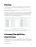
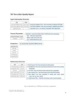
Figure: Correspondence between computer memory and maximum raw point cloud file size
All L1 LiDAR data processing functions are free of charge except point cloud accuracy optimization.
You can download and install the software from the DJI website:
https://www.dji.com/downloads/products/dji-terra
Optimize Point Cloud Accuracy: When enabled, DJI Terra will optimize point cloud data collected at
different times during processing for higher overall consistency. This is a premium feature included in
DJI Terra Pro and more advanced versions. Each L1 comes with a 6-month license for the Electricity
version. You can find the license information in the package. Note: With the complimentary DJI Terra
license, you can only bind 1 device and cannot unbind it.
4.2 Reconstruction Steps
(1)
Create a mission and select "LiDAR Point Cloud Processing" as the mission type.
Figure: LiDAR point cloud processing types


