Copyright © 2022 DJI All Rights Reserved.
32
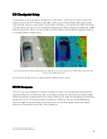
Figure:
Parking Lot lines in the point cloud result (left: reflectivity; right: RGB)
3.5.2 Elevation Checkpoints
When you use third-party point cloud analysis software such as TerraSolid, LiDAR360 or Point Cloud
Automata, they may provide the feature to output an elevation accuracy report. Usually, the elevation
accuracy check feature is based on the assumptions that the horizontal accuracy of the LiDAR system
can be neglected, and the points near the checkpoint are all on the same elevation plan.
Therefore, it is recommended to set up the elevation checkpoint on a flat surface of at least 1m*1m in
size. The checkpoints should be evenly distributed in the survey area and have differences in
elevation, rather than all being located on the same plane. To test the penetrability of LiDAR, it is
recommended to set a certain number of checkpoints under trees.
Figure: An elevation accuracy report produced by Terrasolid

