A-Rival 2.5 User’s Guide
38
6 While on the Road
6.1 Travel Information
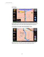
The black bar below the map provides you with miscellaneous information about the
trip:
The orange action icon indicates the next driving maneuver.
The box with the three arrows in the left upper corner of the map viewer show
you the lane info for the next diversion. You should follow the orange arrows.
The lane info is most common on freeways, highways and big crossings.
460 meters: Indicates the distance remaining until the next maneuver must be
carried out.
1:18: Indicates the calculated arrival time.
48 min: Indicates the remaining driving time.
84 km: Indicates the remaining distance.
1 AS Bonn-Bad Godesberg: Indicates the name of the street you will turn into
after the next driving maneuver.
The tmc and gps receiving is shown in the upper left corner.
green: means good receiving quality
grey: means bad or no receiving
no symbol: means that no tmc or gps device is active
red (only tmc): traffic jam on route
In the upper middle of the display there are the signs you have to follow.


