background image


Distributed by 


Any reference to Raytheon or 

RTN in this manual should be 

interpreted as Raymarine. 

The names Raytheon and RTN 

are owned by the 

Raytheon Company. 


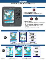
Summary of Contents for Marine GPS System

Page 1: ...Distributed by Any reference to Raytheon or RTN in this manual should be interpreted as Raymarine The names Raytheon and RTN are owned by the Raytheon Company...

Page 2: ...F Ft t t L L La a au u ud d de e er r rd d da a al lle e e F F FL L L 3 3 33 3 33 3 30 0 09 9 9 U U US S SA A A w w ww w ww w w r r ra a ay y ym m ma a ar r ri iin n ne e e c c co o om m m R R Ra a ay...

Page 3: ...rained and experienced in navigation This Product is intended for use only by persons trained in nautical navigation and only as a navigational aid not as the sole method of navigation NOTICE You may...

Page 4: ...ration instructions This Guide is intended for users with varying technical and nautical backgrounds but assumes a general level of PC and related software environment experience as well as a moderate...

Page 5: ...Point your browser to www raymarine com When you are required to access choose items from drop down menus the word select is used Menus levels are shown separated by a forward slash For example From...

Page 6: ...t ta a at t te e es s s Toll Free 1 800 539 5539 X2333 Standard 1 603 881 5200 X2333 FAX 1 603 864 4756 T T Te e el l le e ep p ph h ho o on n ne e e E E Eu u ur r ro o op p pe e e Telephone 44 0 23 9...

Page 7: ...vi...

Page 8: ...a a ay y yt tth h he e eo o on n n s s s S S Se e ea a aT T Ta a al llk k k a a an n nd d d N N NM M ME E EA A A 0 0 01 1 18 8 83 3 3 D D Da a at tta a a O O Ou u ut ttp p pu u ut tt D D De e ev v vi...

Page 9: ...s 3 3 3 7 7 7 S S St tta a an n nd d da a ar r rd d d T T To o oo o ol llb b ba a ar r r 3 3 3 7 7 7 W W Wa a ay y yp p po o oi iin n nt tt a a an n nd d d R R Ro o ou u ut tte e es s s T T To o oo o...

Page 10: ...n B B Bu u ut ttt tto o on n n 3 3 3 2 2 20 0 0 V V VR R RM M M E E EB B BL L L B B Bu u ut ttt tto o on n ns s s 3 3 3 2 2 21 1 1 T T Tu u un n ne e e B B Bu u ut ttt tto o on n n 3 3 3 2 2 22 2 2 S...

Page 11: ...tts s s 4 4 4 2 2 20 0 0 W W Wo o or r rk k ki iin n ng g g W W Wi iit tth h h W W Wa a ay y yp p po o oi iin n nt tt G G Gr r ro o ou u up p ps s ss s s 4 4 4 2 2 22 2 2 U U Us s si iin n ng g g t t...

Page 12: ...iio o on n n 5 5 5 2 2 20 0 0 T T Ta a ar r rg g ge e et tt W W Wa a ak k ke e es s s 5 5 5 2 2 21 1 1 M M Me e ea a as s su u ur r ri iin n ng g g R R Ra a an n ng g ge e e a a an n nd d d B B Be e e...

Page 13: ...s si iit tti iiv v vi iit tty y y 5 5 5 4 4 41 1 1 A A Ad d dj jju u us s st tti iin n ng g g t tth h he e e C C Co o ol llo o or r r G G Ga a ai iin n n 5 5 5 4 4 42 2 2 U U Us s si iin n ng g g t tt...

Page 14: ...ng g gl lle e e C C Ca a al lli iib b br r ra a at tti iio o on n n 5 5 5 6 6 67 7 7 T T Tr r ru u ue e e W W Wi iin n nd d d S S Sp p pe e ee e ed d d C C Ca a al lli iib b br r ra a at tti iio o on...

Page 15: ...aces with your boat s onboard navigational systems offering you the flexibility to allow Navigator to autopilot your vessel to any destination you choose to plot Navigator also incorporates the capabi...

Page 16: ...enable your vessel s autopilot to follow the route waypoints you have designated Routes and waypoints can easily be changed on the fly should weather or other factors necessitate a change in course Mu...

Page 17: ...ial imagery chart Comprehensive Weather Oceanographic Reporting Navigator offers you the capability to download and display the latest weather and ocean conditions and then superimpose this informatio...

Page 18: ...information with just a few mouse clicks You can zoom deeply into charts to display the maximum level of detail for the region you are in animate weather and oceanographic files to monitor the meteoro...

Page 19: ...o to ARPA Radar systems This allows targets identified by Radar to be plotted on directly onto Navigator s chart displays You can also connect Navigator to a variety of proprietary instruments and gen...

Page 20: ...orrected wind angles boat speed heel pitch and so forth to determine what heading you should set your boat upon to achieve the best possible speed under varying wind conditions Analysis results are di...

Page 21: ...be hiding Plankton content areas of the ocean presented as overlays upon your navigational charts so that you can easily identify clear fish filled waters 3 D bathymetric charts to precisely identify...

Page 22: ...the Internet Note How to connect external devices such as GPS Radar Sonar and autopilots is explained in Appendix A Connecting Peripheral Instruments Before You Begin Before you can begin installing...

Page 23: ...T4 Recommended System Requirements Pentium III or higher 128MB of RAM or more NVIDIA GeForce graphics card Windows 2000 XP Setting Your PC Monitor s Colors for Best Display To fully utilize Navigator...

Page 24: ...ll need your Navigator License Key s A License Key is a sequence of digits and characters you enter initial configuration explained later in this chapter to activate Navigator and enable its various o...

Page 25: ...me Screen 2 Click Next The InstallShield Wizard ISW License Agreement screen Figure 2 2 is displayed This screen contains Navigator s Licensing Agreement Legal Disclaimers Figure 2 2 InstallShield Wiz...

Page 26: ...3 InstallShield Wizard Customer Information Screen 4 Type the name of the person and the organization to whom this version of Navigator is being licensed then choose whether you want Navigator to be u...

Page 27: ...on screen is displayed after you pick this option and click Next 5 Click Complete or Custom then click Next to continue If you select Complete skip to Step 10 If you select Custom continue with this s...

Page 28: ...ated subcomponents This feature will be installed when required This feature will not be available does not install the selected component Keep in mind that you need a License Key for each Optional Mo...

Page 29: ...lick Install on the ISW Ready to Install screen to begin the installation The progress of the installation is displayed on the screen and after a few moments the ISW Completed screen Figure 2 7 appear...

Page 30: ...Installation from Raymarine s Web site is very similar to installing from a CD To install Navigator from the Internet do the following 1 Point your Internet browser to www raymarine com raytech 2 Fol...

Page 31: ...nctionbars and what they do All menu levels and functions are illustrated and described enabling you to work smoothly and efficiently within Navigator Main Interface Component Descriptions This sectio...

Page 32: ...RayTech Navigator User s Guide 3 2 Figure 3 1 Navigator s Main Interface...

Page 33: ...ach of the main interface drop down menus File Waypoint etc Figures 3 2 through 3 9 and gives brief functional descriptions of each menu item File Menu Figure 3 2 File Drop Down Menu Item Descriptions...

Page 34: ...RayTech Navigator User s Guide 3 4 Route Menu Figure 3 4 Route Drop Down Menu Item Descriptions Tools Menu Figure 3 5 Tools Drop Down Menu Item Descriptions...

Page 35: ...Using Navigator s Interface 3 5 Tools Pre Start Menu Figure 3 6 Tools Pre Start Drop Down Menu Item Descriptions View Menu Figure 3 7 View Drop Down Menu Item Descriptions...

Page 36: ...RayTech Navigator User s Guide 3 6 Window Menu Figure 3 8 Window Drop Down Menu Item Descriptions Help Menu Figure 3 9 Help Drop Down Menu Item Descriptions...

Page 37: ...Toolbars Standard Charting etc Figures 3 10 through 3 21 and gives brief functional descriptions of each Toolbar item Standard Toolbar Figure 3 10 Standard Toolbar Item Descriptions Waypoints and Rou...

Page 38: ...RayTech Navigator User s Guide 3 8 Charting Toolbar Figure 3 12 Charting Toolbar Item Descriptions Alarm Toolbar Figure 3 13 Alarm Toolbar Item Descriptions...

Page 39: ...Using Navigator s Interface 3 9 Animation Toolbar Figure 3 14 Animation Toolbar Item Descriptions Tides Currents Toolbar Figure 3 15 Tides Currents Toolbar Item Descriptions...

Page 40: ...RayTech Navigator User s Guide 3 10 3 D View Toolbar Figure 3 16 3 D View Toolbar Item Descriptions Fishing Toolbar Figure 3 17 Fishing Toolbar Item Descriptions...

Page 41: ...s Interface 3 11 Yacht Racing Toolbar Figure 3 18 Yacht Racing Toolbar Item Descriptions Pre Start Toolbar Figure 3 19 Pre Start Toolbar Item Descriptions Weather Toolbar Figure 3 20 Weather Toolbar I...

Page 42: ...21 Pathfinder Toolbar Item Descriptions Functionbar Menus Standard Functionbar This subsection illustrates the Standard Functionbar s menu hierarchy Figure 3 22 then gives brief explanations for the...

Page 43: ...Using Navigator s Interface 3 13 Figure 3 22 Standard Functionbar Menu Hierarchy...

Page 44: ...igator User s Guide 3 14 Route Button Figure 3 23 Functionbar Route Button Descriptions Goto Button Figure 3 24 Functionbar Goto Button Descriptions Marks Button Figure 3 25 Functionbar Marks Button D...

Page 45: ...Using Navigator s Interface 3 15 Top Level More Button Figure 3 26 Functionbar Top Level More Button Descriptions Second Level More Button Figure 3 27 Functionbar Second Level More Button Descriptions...

Page 46: ...RayTech Navigator User s Guide 3 16 File Button Figure 3 28 Functionbar File Button Descriptions Weather Animation Button Figure 3 29 Functionbar Weather Animation Button Descriptions...

Page 47: ...re 3 30 Functionbar Setup Button Descriptions Radar Functionbar This subsection illustrates the Radar Functionbar s menu hierarchy Figure 3 31 then gives brief explanations for the function of the but...

Page 48: ...RayTech Navigator User s Guide 3 18 Figure 3 31 Radar Functionbar Menu Hierarchy...

Page 49: ...19 Heading Mode Button Figure 3 32 Radar Functionbar Heading Mode Button Descriptions Targets Button Figure 3 33 Radar Functionbar Targets Button Descriptions Marpa Button Figure 3 34 Radar Functionb...

Page 50: ...RayTech Navigator User s Guide 3 20 Gain Button Figure 3 35 Radar Functionbar Gain Button Descriptions...

Page 51: ...1 VRM EBL Buttons The VRM EBL Functionbar buttons can only be accessed in an open Radar window by clicking the VRM EBL button on the Pathfinder Panel Toolbar see Figure 3 21 Figure 3 36 Radar Function...

Page 52: ...cking the MULTI button on the Pathfinder Panel Toolbar see Figure 3 21 Figure 3 37 Radar Functionbar Tune Button Descriptions Sonar Functionbar This section illustrates the Sonar Functionbar s menu hi...

Page 53: ...Using Navigator s Interface 3 23 Figure 3 38 Sonar Functionbar Menu Hierarchy...

Page 54: ...RayTech Navigator User s Guide 3 24 Frequency Button Figure 3 39 Sonar Functionbar Frequency Button Descriptions Zoom Button Figure 3 40 Sonar Functionbar Zoom Button Descriptions...

Page 55: ...Using Navigator s Interface 3 25 Bottom Lock Button Figure 3 41 Sonar Functionbar Bottom Lock Button Descriptions A Scope Button Figure 3 42 Sonar Functionbar A Scope Button Descriptions...

Page 56: ...26 VRM EBL Buttons The VRM EBL Functionbar buttons can only be accessed in an open Sonar window by clicking the VRM EBL button on the Pathfinder Panel Toolbar see Figure 3 21 Figure 3 43 Sonar Functio...

Page 57: ...3 27 Alarm Buttons The Alarm Functionbar buttons can only be accessed in an open Sonar window by clicking the ALARMS button on the Pathfinder Panel Toolbar see Figure 3 21 Figure 3 44 Sonar Functionba...

Page 58: ...vigator Drop down menu commands Toolbars Keyboard input Toolbar and Menu display appearance Toolbar and Menu display behavior Using the Customize Dialog Box This subsection illustrates the Customize d...

Page 59: ...the Categories window select the drop down menu that contains the command you want to move to another drop down menu The available commands for that menu are displayed in the Commands window 3 Highlig...

Page 60: ...beside the Toolbar s you want to reset 2 Click Reset or if you want to reset all the Toolbars at once click Reset All To create and name a custom Toolbar 1 Click New The Toolbar Name dialog box is di...

Page 61: ...Using Navigator s Interface 3 31 Figure 3 46 Customize Dialog Box Toolbars Tab Check the Toolbars you want to display or modify Click button to perform desired operation on Toolbar...

Page 62: ...play area select Customize to display the Customize dialog box 2 Click the Keyboard tab Figure 3 47 3 From the Category drop down menu select the menu that contains the command you want to create a sh...

Page 63: ...vigator s Interface 3 33 Menu Tab The Menu tab of the Customize dialog box is currently non functional within Navigator however it will display if the tab is clicked Figure 3 48 Customize Dialog Box M...

Page 64: ...structures To display the Options tab 1 From the View menu or right click near the Toolbar display area select Customize to display the Customize dialog box 2 Click the Options tab Figure 3 49 3 Chec...

Page 65: ...ge of Navigator This chapter covers the following areas Installing displaying and manipulating the various chart types Creating editing and implementing waypoints and routes Getting and using the late...

Page 66: ...ling the charts onto your PC to the chart manufacturer Refer to the instructions that came with the CD Where to Store Charts The best place to store your charts is on the hard drive of the PC that s r...

Page 67: ...Working With Charts And Routes 4 3 Figure 4 1 RayTech Settings Dialog Box Figure 4 2 Chart Manager Screen 1 Double click Raster Charts icon to begin installing charts...

Page 68: ...ing new charts 4 Click Install New Charts Chart Installer screen 1 is displayed Figure 4 3 Figure 4 3 Chart Installer Screen 1 5 If you know where the charts you want to load are click Browse and loca...

Page 69: ...o install every chart then click Install Now The progress of each chart s installation is shown When the charts have been installed Chart Manager screen 1 is redisplayed Figure 4 5 Figure 4 5 Chart Ma...

Page 70: ...vigator the active leg of a route is represented by a dashed line and a blinking gray circle around the destination waypoint Plotting a route requires just a few mouse clicks and you can easily move a...

Page 71: ...ute menu or click the Create Route button on the toolbar The Quick Route dialog box is displayed Figure 4 7 Figure 4 6 Two Ways of Starting a Route Figure 4 7 Quick Route Dialog Box To start a route S...

Page 72: ...OK The Standard cursor changes to the Route cursor Figure 4 8 Move the cursor over the area where you want the route to begin then left click the mouse The route is started and the name you chose alo...

Page 73: ...long with the range and bearing of each leg is displayed between each waypoint Figure 4 9 5 As shown in Figure 4 9 when you reach the end of the route right click and select Finish Quick Route or just...

Page 74: ...ypoints Modifying waypoint display characteristics What are and how to place relative waypoints Creating and editing waypoint groups Using the waypoint recycle bin Adding moving renaming and deleting...

Page 75: ...waypoint group that contains the waypoint s you want to add to the selected route 3 Highlight the waypoint you want to add 4 Under Currently active route highlight the waypoint after which you want th...

Page 76: ...ve then press and hold the left mouse button 2 Move the cursor to the position on the chart where you want the waypoint moved then release the button The waypoint moves to the new location Figure 4 12...

Page 77: ...oaching is moved to your vessel s current location Figure 4 13 Moving the Waypoint You Are Approaching To The Vessel To move the waypoint you re heading away from to your vessel s current position 1 A...

Page 78: ...int At Vessel information dialog box appears Figure 4 16 The dialog box shows the time the waypoint is added and has a space where you can type relevant infor mation such as location water depth and t...

Page 79: ...Marks Wpt at Cursor on the function bar this function cannot be accessed from the Waypoints drop down menu The Standard cursor changes to the Route cursor 2 Place the cursor where you want the new way...

Page 80: ...at Cursor from the Waypoint menu click MOB on the toolbar or click More More Man Overboard on the function bar The man overboard marker is placed automatically at the vessel s current position Navigat...

Page 81: ...play the Chart Action popup menu Figure 4 19 2 Select Delete Waypoint The waypoint is removed from the chart Note You can also delete waypoints from the Waypoint Properties dialog box Refer to Modifyi...

Page 82: ...t you want to modify then right click to display the Chart Action popup menu 2 Select Waypoint Properties to display the Waypoint Properties dialog box Figure 4 20 Note You can also double click on a...

Page 83: ...nsertion point Longitude field Longitude coordinate of waypoint Bearing field Displayed only if Relative box is checked and Pinged box is unchecked Displays bearing of waypoint in Metric or English un...

Page 84: ...layed the same relative distance from another waypoint To set one waypoint as relative to another 1 As explained previously create two waypoints or decide which two existing waypoints you want to use...

Page 85: ...t one waypoint to specific coordinates 1 Double click on WP2 to display the Waypoint Properties dialog box Figure 4 20 2 Make sure that the Relative and Pinged boxes are checked 3 Type the specific co...

Page 86: ...e Waypoint Recycle Bin To create a new waypoint group 1 Select Edit Route from the Route menu then click Waypoint Properties to display the Waypoint Properties dialog box Figure 4 20 2 As shown in Fig...

Page 87: ...e Group Name drop down menu then select the group you want to rename 3 As shown in Figure 4 20 click Groups to display the Group Action popup menu 4 Select Rename Waypoint Group The Rename Waypoint Gr...

Page 88: ...then select the group you want to delete 3 Click Groups to display the Group Action popup menu 4 Select Delete Waypoint Group A dialog box appears Figure 4 23 warning you that deleting a waypoint grou...

Page 89: ...select the group you want to delete 3 Click Groups to display the Group Action popup menu 4 Select Show Group on Chart to display the waypoints or Hide Group on Chart to remove them A confirmation di...

Page 90: ...he Waypoint Properties dialog box Figure 4 20 2 As shown in Figure 4 25 click the Group Name drop down then select Recycle Bin from the displayed choices The Move Waypoints Between Groups dialog box i...

Page 91: ...7 Figure 4 26 Retrieving Waypoints From The Recycle Bin STEP 1 Click drop down then select waypoint group to restore to STEP 2 Select waypoints you want to retrieve from Recycle Bin STEP 3 Click Move...

Page 92: ...puts to a PCMCIA card in your PC When a scanner is connected and the radar is in Transmit mode the radar picture provides a map like representation of the area in which the radar is operating Typicall...

Page 93: ...chapter with the radar display set to simulator mode or on the water after you have installed and set up your hsb2 Series Pathfinder Plus Radar system Note Until you are familiar with interpreting th...

Page 94: ...played over the chart 3 Click the down arrow adjacent to the Radar Overlay window The transparency slider appears 4 Move the transparency slider up down to decrease increase the overlay s transparency...

Page 95: ...ngs To display the Control Panel 1 From within the Radar Window click the right mouse button 2 Select View Control Panel The Control Panel Figure 5 1 is displayed along the side of the radar window 3...

Page 96: ...on the Standard toolbar When the Radar window is active clicking the Pathfinder Panel buttons displays the following GAIN FTC RAIN SEA and GAIN Radar Functionbar buttons VRM EBL VRM EBL Radar Function...

Page 97: ...fronts and large ship targets in or beyond view The short range scales provide greater detail of the radar echoes close to your vessel and should be used as you approach the coastline harbor or other...

Page 98: ...ange Rings Range Ring Interval nm 0 125 0 25 0 5 0 75 2 2 4 3 0 0625 0 125 0 125 0 25 1 5 3 6 6 0 25 0 5 6 12 24 48 72 6 6 6 6 6 1 2 4 8 12 The maximum range depends on your scanner type The number of...

Page 99: ...the height of the target as shown below lists some range examples Radar Range Antenna Height m Target Height m Maximum Range nm 3 3 7 8 3 10 10 9 5 3 8 9 5 10 12 0 Note The ranges shown in the table a...

Page 100: ...e and brightness of the echoes Some targets such as buoys and small boats can be difficult to differentiate since they bob and toss about in the waves and do not present a consistent reflecting surfac...

Page 101: ...et expansion on off Turns wakes on off and selects wakes length ON OFF OFF Identifying False Echo Returns Not all echoes are direct returns to the radar antenna Occasionally signals appear at position...

Page 102: ...at short range may produce an arc on the radar screen similar to a range ring or a series of echoes forming a broken arc Side lobe echoes normally occur at ranges below 3nm and can be reduced by adjus...

Page 103: ...hown in the figure below This is not very common Figure 5 4 Radar Multiple Echo Affects Blind Sectors or Shadow Effect Funnels and masts located near the antenna may cause shadows In shadow areas beyo...

Page 104: ...et to give a slight speckle in the background of the radar picture On shorter ranges you may wish to reduce the gain slightly to reduce the speckle and therefore improve target definition Do not set t...

Page 105: ...detect real targets Sea clutter Figure 5 5 usually appears as multiple echoes on the display at short range scales and the echoes are not repetitive or consistent in position With high winds and extre...

Page 106: ...rol affects the gain you may need to manually readjust it if you manually change the Gain setting To adjust Sea Clutter control 1 Select a range appropriate to the adjustment you want 2 From the Pathf...

Page 107: ...ain clutter at a distance from your vessel such as that shown below Figure 5 6 Radar Rain Clutter Display When the FTC control is turned up only the leading edge of large rain clutter echoes is displa...

Page 108: ...adjustment you want to make 2 From the Pathfinder Panel click the GAIN button The Gain buttons are displayed or Click the right mouse button and select View Control Panel The Control Panel appears 3...

Page 109: ...bove the slider To tune the radar 1 Select a range appropriate to the adjustment you want to make The optimum Tune setting varies slightly for different ranges depending on the pulse width used 2 On t...

Page 110: ...ese controls are accessed from the Functionbar Targets Button To change target mode settings 1 Click the Targets button 2 Click In Rej to toggle On Off 3 Click Expansion to toggle On Off 4 Click Wakes...

Page 111: ...nterference Rejection Display The Pathfinder PLUS Radar includes a mechanism that automatically reduces such interference This mechanism is normally left switched on However if you wish to detect the...

Page 112: ...ed video level You can clear existing wakes from the display by clicking the Clear Wakes Functionbar button When wakes are switched off no new wakes are displayed and existing wakes are cleared Measur...

Page 113: ...bearing information is displayed as either the bearing relative to your vessels heading or if heading data is available from a position fixer or compass the actual bearing in degrees magnetic or degre...

Page 114: ...e current range setting it is placed at its default position instead This is one third of the range for VRM1 and two thirds for VRM2 Using VRM EBL To access VRM EBLs 1 Click the VRM EBL button on the...

Page 115: ...ts last used position The object is displayed with dashed lines 4 From the drop down dialog box select the item that corresponds to the action you want To Move Click Selected VRM EBL combination Edit...

Page 116: ...desired location on the radar screen The mark is placed using the default symbol To place a mark symbol at the current vessel location 1 On the Pathfinder Panel click the MARKS button then click the W...

Page 117: ...ned if one becomes dangerous or is lost Effective MARPA operation is dependent on accurate own ships heading plus SOG and COG The better the quality of the heading data the better MARPA will perform M...

Page 118: ...essing any key silences the alarm and removes the warning but the target symbol remains dangerous Both the distance Own Vessel Safe Zone and the time Time to Safe Zone are selectable If a target is lo...

Page 119: ...to produce a vector that is displayed on the target only This mode is used for collision avoidance and threat assessment A true vector indicates the targets motion over ground In this mode true vector...

Page 120: ...2 Click Acquire Target in the MARPA Box 3 Position the cursor over the required target and click the left mouse button or 1 Click the Marpa button on the Radar Functionbar 2 Click the Acquire Target...

Page 121: ...cted target or 1 Click the right mouse button 2 Select MARPA Clear 3 Click the left mouse button on the selected target to remove it from the screen Using the MARPA Dialog Box The MARPA dialog box Fig...

Page 122: ...target and click the left mouse button To view target data the MARPA List 1 Click MARPA List in the MARPA box The MARPA List box appears displaying Bearing Range Course and Speed of each target To vie...

Page 123: ...bbles also return echoes these echoes are generally weaker than the fish or bottom echoes and produce background noise or clutter on the display Navigator provides controls to reduce the background no...

Page 124: ...the Standard toolbar When the Sonar window is active the Pathfinder Panel Toolbar buttons display the following GAIN GAIN Sonar Functionbar buttons VRM EBL VRM EBL buttons MULTI Power Mode Background...

Page 125: ...waves are returned to the Fishfinder The sound waves are actually reflected by an air sac near the center of the fish not by the body of the fish The size of this air sac is different for different ki...

Page 126: ...er can indicate many different kinds of bottom conditions as shown in Figure 5 12 A hard bottom appears as a thin line An uneven bottom which is covered with rocks or coral produces a complex display...

Page 127: ...r not the depth appears for displayed fish echoes When Target Depth ID is set to ON the depth is displayed just above each fish echo When set to OFF the depth of each echo is not displayed To toggle o...

Page 128: ...ayed below a pallet of available colors The currently selected color is highlighted 3 Select the desired new color and click OK The background color changes 4 Click ENTER CLEAR or BACK to return to th...

Page 129: ...continues update To change the scrolling speed 1 Click MENU on the Pathfinder Panel 2 Click Scroll Speed Two new buttons are displayed 3 Click the Scroll Speed button that appeared A popup dialog app...

Page 130: ...lf of the display window When auto range is selected shift is disabled the value is ignored To adjust the range and shift values 1 On the Pathfinder Panel click RANGE This sets adjustment to manual an...

Page 131: ...to display the associated Functionbar buttons 2 Click Power Mode A drop down menu appears 3 Click to choose between AUTO LOW or HIGH power The selected setting is highlighted 4 Click ENTER CLEAR or B...

Page 132: ...equency selection 4 Click ENTER CLEAR or BACK to return to the top level Functionbar menu Adjusting Display Gain Sensitivity The Gain or sensitivity of the display adjusts background noise by varying...

Page 133: ...ivided equally between the remaining shades colors Setting a low value produces small band for the strongest color but a wide signal band for the other colors setting a high value gives a wide band fo...

Page 134: ...d with dotted lines increases with depth Mode 2 the image expands to take up the entire A Scope window providing greater resolution Mode 3 the left hand side of the image displayed in Mode 2 expands t...

Page 135: ...e above the bottom being displayed You can adjust the Bottom Lock range If the A Scope or Zoom image is displayed selecting Bottom Lock automatically switches off A Scope or Zoom If split frequency se...

Page 136: ...ou can manually pick the area to zoom To use zoom 1 From the top level Functionbar menu click Zoom 2 If necessary click Zoom On Off to toggle zoom on 3 Click Zoom Full Split to toggle between a full w...

Page 137: ...nt to use the shallow and deep water alarms when you are anchored Set the limits to just above and below your anchor depth the Fishfinder triggers an alarm if the anchor drags and the boats moves into...

Page 138: ...rm and clear the alarm message press any key Using VRM The VRM variable range marker key is used on the Fishfinder to determine the depth and distance behind boat of an object on the display The VRM f...

Page 139: ...en it is displayed on screen If the Fishfinder is in split frequency display mode or a zoom window is displayed with the scrolling Fishfinder image then the VRM is shown in both windows at the same po...

Page 140: ...he top of the vertical line The waypoint scrolls to the left with the scrolling bottom display If you place a waypoint at the cursor position in Fishfinder mode and a chart window is open the waypoint...

Page 141: ...r Polars uses a group of variables such as apparent true corrected wind angles boat speed heel pitch and so forth to determine what heading you should set your boat upon to achieve the best possible s...

Page 142: ...d information that you can use to further fine tune the analysis While these screens come pre loaded with default data it is essential to replace as much of this information as possible with real perf...

Page 143: ...ed You can modify the default values shown or you can load an existing Polar Parameters file To modify the values shown skip to Step 4 To load an existing Polar Parameters file click Open The open fil...

Page 144: ...iable Bsp2 Boat speed in knots second variable TwaDn True wind angle Downwind in degrees BspDn Boat speed Downwind in knots Bsp180 Boat speed in knots at 180 degrees sailing directly with the wind 5 E...

Page 145: ...you can store and edit as many different test data rows as you need each row representing a unique run and its associated performance statistics Figure 5 15 Data Tests Screen Double click data row to...

Page 146: ...the test data HeadSail Name code for type of headsail you re using MainSail Name code for type of mainsail you re using Awa Apparent wind angle in degrees The angle of wind as measured by your boats...

Page 147: ...he Twd used to measure performance relative to upwind downwind targets Heading Heading of boat in degrees Heel Amount of heel in degrees Pitch Amount of pitch in degrees Rudder Amount of rudder deflec...

Page 148: ...e finished 4 You can further refine your analysis by using filters to narrow the number of data test rows displayed in the Data Tests screen The Filters screen Figure 5 17 enables you display only tho...

Page 149: ...than or equal to the value entered TWA Displays only those tests having True Wind Angle less than or equal to the value entered BSP Displays only those tests having Boat Speed greater than or equal to...

Page 150: ...fter you have entered your data that information is displayed as a polar graph in the Polar Plot screen Placing the cursor anywhere along the Polar plot yields a small pop up window that displays the...

Page 151: ...ayed in blue on the screen The lines that diverge between 30 and 50 and 130 and 160 represent the correlation between True Wind Angle Twa upwind and downwind respectively and boat speed These lines ar...

Page 152: ...5 61 Figure 5 18 Polar Plot Example Screen Click to set scale of bottom axis boat speed in knots Click to plot optimum heading for selected range of True Wind Speed Current boat speed and heading as e...

Page 153: ...nt to only those elements The Upwind Plot screen Figure 5 19 calculates the best angle and boat speed when sailing upwind and displays Velocity Made Good relative to True Wind Angle click Vmg to view...

Page 154: ...lays Velocity Made Good relative to True Wind Angle click Vmg to view then select the True Wind Speed range to plot by clicking on the Tws kts up down arrows or by entering numbers directly Boat Speed...

Page 155: ...long course racing In such an instance it may be a smarter tactical move to sail toward your target at the fastest possible speed even if that heading isn t directly toward the target To use the Vmc...

Page 156: ...es Boat speed Compass Apparent wind angle True wind angle True wind speed Boat Speed Calibration Boat speed calibrations are entered directly into your instrumentation system refer to your system s ma...

Page 157: ...e wand may not lie exactly on the fore and aft line of the boat Awa calibration is necessary to compensate for this The Awa should read zero when the vane is on the centerline of the boat If you don t...

Page 158: ...dicted based upon the Awa True Wind Angle Calibration True Wind Angle must be calibrated because of the way instrumentation systems measure Awa Since Awa is measured relative to the top of the mast er...

Page 159: ...tly get a lift after tacking you must subtract that correction and add a header correction to the table Here s an example of Twa calibration After tacking five times the average wind direction changes...

Page 160: ...ruments show the same Tws value upwind and down The simplest method to achieve this is to measure wind speed upwind and then calculate an average using the wand method Once the spinnaker is up and the...

Page 161: ...rbo Displays the turbocharger s boost level in pounds per square inch PSI and barometrically BAR range 2 bar 28 psi up to 30 bar 435 psi Turbo Oil Displays the engine turbocharger s oil pressure in PS...

Page 162: ...Single Engine Instrument Panel with Tachometer Displaying the Panel 1 From the File menu select Open The Open Window dialog box is displayed 2 Double click the Engine Panel icon to display the gauges...

Page 163: ...m the pop up menu that appears select Settings The Engine Panel Settings Screen is displayed Figure 5 25 Figure 5 25 Engine Panel Settings Screen Showing Instruments Tab 2 If not already displayed cli...

Page 164: ...shown in Figure 5 26 the checkboxes on the Panel tab allow you to Display gauge sets for one or two engines Set the panel to appear above any other currently displayed Navigator screens if any engine...

Page 165: ...en shows you how to connect the various instruments and devices that can interface with RayTech Navigator These include GPS radar and sonar autopilots and other navigational reporting devices and syst...

Page 166: ...devices In addition to the cable diagram specific NMEA lead connection assignments are given for each type of device Further details are also provided later in this appendix in the section Connecting...

Page 167: ...GS84 To connect directly to a GPS system refer to Figure A 1 and Table A 1 Table A 1 Connecting Navigator Directly to GPS System Connect Cable Color To GPS Lead Yellow Rx NMEA output which may also be...

Page 168: ...to an NMEA equipped instrument system refer to Figure A 1 and Table A 2 Table A 2 Connecting Navigator Directly to NMEA Equipped Instruments Connect Cable Color To NMEA Instrument Lead Yellow Rx NMEA...

Page 169: ...t NMEA TLL or TTM strings If you are going to this feature make sure your radar system is correctly tracking the MARPA targets before connect ing it to Navigator To connect directly to radar refer to...

Page 170: ...the manual that came with your autopilot Your autopilot must support NMEA 2 1 strings APA or APB To connect directly to an autopilot refer to Figure A 1 and Table A 4 Table A 4 Connecting Navigator D...

Page 171: ...ng Cable Part No E86001 as shown in Figure A 2 This interface converts the SeaTalk data format into RS 232 signals and vice versa When configuring your instrument connections within Navigator the COM...

Page 172: ...by the Z290 Therefore to ensure full communications we recommend that you use the Direct SeaTalk Interface To connect directly to a Raytheon Autohelm system refer to Figure A 1 and Table A 5 Table A 5...

Page 173: ...all a jumper on the Performance Board between the RTS Pin and the CTS Pin 2 Set the Output Baud Rate setting Cross Track Error calculation value 2 to 6 4bps Refer to the B G manual for instructions 3...

Page 174: ...you will also need the NMEA Box because the Race Box doesn t propagate all of the NMEA data To connect to a KVH Race Box refer to Figure A 1 and Table A 8 To connect to an NMEA Box refer to NMEA Basi...

Page 175: ...Ockam RS 232 Interface however to ensure optimum reliability of the data transfer we recommend that you use Ockam Model 050D To connect to an Ockam Model 050D RS 232 Interface 1 Set Switch S1 on Model...

Page 176: ...e difference between the two wires hence the NMEA output signal is called a Differential Data Signal not to be confused with Differential GPS which is a GPS system error correction method Differential...

Page 177: ...le s signal ground with the vessel s power ground circuit While the vessel s power ground may coincidentally be at the same level as the RS 232 signal ground there is no industry standard that require...

Page 178: ...rom an NMEA device 1 Connect the RS 232 Device s Tx lead to the NMEA Device s Rx lead 2 Connect the RS 232 Device s Rx lead to the NMEA Device s Tx lead 3 Connect the RS 232 Device s SGnd lead to the...

Page 179: ...or all but the shortest length cable runs data cables must be shielded to prevent them from picking up electrical noise from other devices and to keep them from radiating potential interference If you...

Page 180: ...rt No E86001 Table A 10 Pin Lead Configuration for 9 Pin KiwiTech NMEA Cable 9 Pin Serial Connector PC Cable Color Direct SeaTalk Interface NMEA GPS Pin 2 Red RS232 Out Data Out Pin 3 White NMEA In Da...

Page 181: ...utton on the Route toolbar or Select Waypoint Transfer from the Waypoint menu The Waypoint Route Transfer dialog appears 2 Select the Method by which you wish to send the waypoint route These Waypoint...

Page 182: ...t route storage capacity of the Raymarine electronic device RayTech notifies you accordingly 6 Whenyouaresatisfiedwiththelistofwaypoints routestobetransferred click the Send button Thewaypoints routes...

Page 183: ...fer dialog 2 Click the Change Option button to select the waypoints routes to be sent as described in the preceding section Transfer via hsb2 3 Click Save Now The Save As dialog appears 4 Browse to th...

Page 184: ...Create Route button from the Route toolbar or by selecting Create Route item from the Route menu Wheninroute waypointplottingmode thecursorappearsasacrosshairwith asmallwaypointsymboladjacenttoit Rout...

Page 185: ...theChartInfodialog thereis acheckboxforincludingachartinthequiltand a button for displaying a chart alone In the Chart Layers Toolbar is a new Quilting button for turning the feature on and off Zoom...

Page 186: ...client such as Microsoft Outlook Outlook Express for transmission by cellular satellite or SSB e mail Upon delivery to the recipient the position report can be automatically decoded and plotted on an...

Page 187: ...generated andpassedtothee mailclient s outbox for transmission If your e mail system is not automatic the position report will remain in the outbox until you reconnect to your e mail At that time any...

Page 188: ...t delineating start and end points for the data capture These lines called wands representaparticularsegmentof time on the graph Thetimeinterval is reported at the top of the graph in the blue status...

Reviews: