background image


Easytrak Nexus Lite 

2695 Series  

Operation Manual 


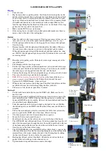
Summary of Contents for Easytrak Nexus Lite 2683

Page 1: ...Easytrak Nexus Lite 2695 Series Operation Manual ...

Page 2: ...2695 Series Operation Manual EZT 2695 8000 1 Page 2 of 124 Revision History Issue Change No Reason for change Date 1 N A First Issue 25 01 17 ...

Page 3: ... Over The Side 15 Pole Mounted Through A Gate Valve 15 Suspended Over the Side 16 DECK CABLE 17 5 OPERATION 18 POWER UP 18 FRONT PANEL INDICATORS 18 6 EASYTRAK NEXUS LITE SOFTWARE 19 OVERVIEW 19 TASK MENU BAR 20 NEXUS LITE CONFIGURATION 22 WORKSPACE CONFIGURATION 22 Display Options 22 Preferences 23 Vessel 24 SYSTEM CONFIGURATION 25 Data In 25 Data Out 26 Transceiver 29 Notes on Transducer Depth a...

Page 4: ...REMENT 59 PLACEMARKS 60 WAYPOINTS 61 RECORDER PLAYBACK 62 TOOLS MENU 63 PROGRAMMING 63 ADVANCED USER MODE 64 ACOUSTIC MONITOR 64 HELP MENU 66 ABOUT 66 USER INFORMATION 66 REQUEST SUPPORT 67 6 CALIBRATION 68 6 1 STATIC CALIBRATION 69 6 2 EASYCAL 2 USBL CALIBRATION 70 EASYCAL 2 PROCEDURE 71 ACQUISITION MODE 72 LOGGING DATA 76 PROCESSING MODE 77 FILES 77 IMPORT A LOGGED FILE 77 MERGE ADDITIONAL FILE ...

Page 5: ...RAD HPR 309 DATA TELEGRAM 104 SIMRAD PSIMSSB DATA STRING 107 SIMRAD PSIMSNS DATA STRING 108 PSEUDO GPRMC DATA STRING 109 KLEIN 3000 SSS DATA STRINGS 110 KLEIN 3000 DATA STRINGS CONTINUED 111 PSEUDO GPGGA DATA STRING 112 11 SYSTEM SPECIFICATION 113 EASYTRAK NEXUS CONSOLE MODEL 2695 113 EASYTRAK NEXUS TRANSCEIVER MODEL 2683 114 ACCURACY PERFORMANCE 114 TRANSCEIVER CABLE 114 ENVIRONMENT 115 HANDLING ...

Page 6: ... of this manual or equipment it describes Equipment suitability and any operational issues such as safe working practices and risk assessments are the responsibility of the user The manual is believed to be correct at the time of printing However software updates or hardware changes may mean there are differences between the manual and the software hardware contained in any particular product If i...

Page 7: ... reflections and other types of acoustic interference the position can occasionally be corrupted In gating and smoothing modes Easytrak has the facility to gate out wild values of velocity The out of gate positions are replaced by predicted values Note the compass must be enabled The Easytrak Nexus Lite transceiver is fitted with internal compass pitch and roll sensors The pitch and roll sensors w...

Page 8: ...ovide greater positioning accuracy particularly appropriate at low depression angles where the slightest change can result in a significant shift in the target s vertical position Note When using GPS bearings are relative to GRID North without GPS bearings are relative to TRUE North or with the compass switched off the vessel s Bow Though Easytrak Nexus Lite is simple to use the system provides a ...

Page 9: ... bearing and depression angle to the target are computed For a TRANSPONDER time taken from the vessel s interrogating transmission through the water to the reception of the target acoustic signal provides the range Range VOS x Travel time m 2 The divide by 2 is because sound has to travel to and from the target i e twice the distance For a RESPONDER time taken from the vessel electrical interrogat...

Page 10: ... The Easytrak Transceiver transmits and receives acoustic signals using a multi element ceramic transducer It determines the position of dynamic subsea targets through the transmission and reception of acoustic signals between the submerged transceiver and the target beacon The transceiver is fitted with integral depth temperature compass pitch and roll sensors to automatically compensate external...

Page 11: ...0MB Please install software on supplied CD before connecting the Easytrak Nexus Lite to the PC To install the software please run the Setup exe program on the installation CD Depending on the operating system and user updates installed the installation may need to install Microsoft NET 4 before proceeding The install will proceed as shown below follow the on screen prompts Upon successful completi...

Page 12: ...utput TRANSCEIVER Connection to the Nexus 2683 Transceiver using the Nexus Deck Cable RESPONDER BNC connection to beacon to triggered as a responder NAV IN BNC connection for external synchronisation key for system 48VDC INLET The 48VDC power supply is auto ranging 115 230VAC 50 60Hz and doesn t require user intervention Plug into the nearest power outlet socket SAFETY EARTH Connection for vessel ...

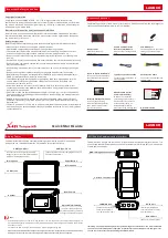
Page 13: ...2695 Series Operation Manual EZT 2695 8000 1 Page 13 of 124 ...

Page 14: ...2695 Series Operation Manual EZT 2695 8000 1 Page 14 of 124 Easytrak Nexus 2683 Transceiver Deployment Options Suspended Pole Mounted ...

Page 15: ...e alignment mark on the transducer is inline forward with the forward aft line of the vessel Extreme care has to be taken in shallow water that the transducer does not strike the seabed See appendix A and B for mounting bracket dimensions Pole Mounted Through A Gate Valve Ensure the gate valve is of a suitable diameter to take the transducer and any mounting hardware The transducer should be mount...

Page 16: ...eployed the transducer is below the draft of the vessel by at least 1 metre and has clear horizontal visibility through 360 Note the suspended over the side method cannot be used if the compass is not enabled as the system would have no orientation reference Also if GPS positioning is required the antenna must be directly over the transducer otherwise offset errors can occur System installation is...

Page 17: ...le away from sources of electrical noise such as electrical generators sonar sources bang boxes etc Avoid trapping the cable in doorways hatches and alike Ensure the cable is not bent less than the minimum bend radius of 150mm Ensure the cable is not laid over sharp edges When deployed over the side of a vessel ensure that the cable is secured to any mounting pole to prevent chaffing strumming and...

Page 18: ...Application The system will automatically detect the 2695 Console and set the configuration to the selected setup To power down the system close the Nexus Lite Application and power down the 2695 console Front Panel Indicators PWR will indicate Green when Nexus Lite Unit is powered ON TRANS will indicate Green when power is ON to the Transceiver TX RX will indicate Green upon a beacon interrogatio...

Page 19: ... for easy reconfiguration of the system There is no limit to the number of setup files that may be saved on the system so multiple setups can be pre configured Each of the display windows can be accessed from either the Menu bar from the Tool Bar or via a keyboard shortcut Each window can be resized and positioned as required or auto positioned within the window area There is a Status Bar with sys...

Page 20: ...y Hide Placemarks Window Display Hide Waypoints Window Display Hide Beacon Data Window Display Hide Beacon Editor Window Display Hide Transceiver Monitor Window Display Hide Vessel Pitch Roll Window Display Hide Vessel Monitor Window Display Hide Plot Window Set Plot Window to Grid Display Mode Set Plot Window to Polar Display Mode Revert to previously selected centralize mode Enable Map Overlay o...

Page 21: ...ints Open Save As Placemarks Save As Plot Events Waypoints Plot Placemarks Beacon Editor Beacon Data Transceiver Monitor Vessel Monitor Gating Smoothing Recorder Auto Position Windows Programming Nexus Console Transceiver GPS Time Sync About User Info File Windows Tools Help System Setup Open Save Save As Beacon Setup Open Save Save As Calibration USBL Calibrate Compass Calibrate Windows Snap Adva...

Page 22: ...s area Beacon The setup of beacons such as frequencies ranges types etc are configured within the beacon editor 1000 Series beacons may be connected to display and set beacon properties Workspace Configuration Toolbar Button The three tabs contained within the workspace configuration are described below Note that the title bar of this window shows the name of currently loaded workspace file in bra...

Page 23: ...may be enabled disabled using the Load checkbox If Autosave is checked then the file will automatically be saved when closing down the unit Lat Long Display The positions of beacons and vessel may be displayed in either UTM s or Lat Long mode If Lat Long mode is selected then the format can be either decimal degrees degrees and decimal minutes or degrees minutes and seconds Fix Numbers The start v...

Page 24: ...il Points Trail points for the vessel can be configured including the number of points the colour of the trail points and whether the end of the trail fades away The points may be joined and also the fix number and time can be displayed at fixed intervals Vessel Image The vessel image option allows the user to select the vessel image that will be used for the plot window The user can select from a...

Page 25: ...red in Workspace Preferences Data In The Data In tab of the system configuration allows the Serial Ports to be configured for external inputs GPS VRU Gyro Target Depth Target Heading Beacon AAE 1000 and 1100 series only A device type of Multiple may also be selected in this mode heading gyro and GPS data may be input on a single port Serial set up options Baud rate 2400 4800 9600 19200 38400 57600...

Page 26: ...d the external positional data can be applied to the calculated position to give an absolute position of the target Tick Apply GPS Data to calculate absolute positions Go to the UTM Grid Setup tab to configure the local grid origins For GPS time synch only configure a serial port and do not apply GPS data View Port Monitor The View Port Monitor button may be used to view valid data being received ...

Page 27: ...e applied to the computed position A Compass must be used to be north referenced otherwise the data will be corrected bow referenced The positions derived in this mode are not affected by any gating or smoothing setting Gated Positions are referenced to the NORTH North referenced values are used except where a value falls outside a user selected Gate or a reply is lost The lost reply or out of gat...

Page 28: ...ersion of the ORE Trackpoint 2EC string TP EC W PR ORE Trackpoint string including pitch roll Simrad 300P Simplified version of the Simrad string Simrad 309 Simplified version of the Simrad string Simrad PSIMSSB HiPAP NMEA format strings Pseudo GPRMC Pseudo GPS format string NMEA GPGGA NMEA GPGGA format string NMEA GPVTG NMEA GPVTG format string NMEA GPTLL NMEA GPTLL format string Pseudu GPGGA A c...

Page 29: ...ng Reference Offsets Offsets are the measured distances from the reference point to the transceiver The vessel plan diagrams update with an indication of the transceiver position referenced to the desired point Fixed Installation Offsets Fixed Installation Offsets As a result of calibration or measurement the installation offsets can be applied A positive value of bearing indicates a clockwise off...

Page 30: ...gnetic north and true north Declination is considered positive when the angle measured is east of true north and negative when west Magnetic declination varies throughout the world changing slowly over time Magnetic declination is entered into Easytrak Nexus in the following format SDDD DD where S is the sign East or West and D are degrees and decimal degrees The transducer internal compass and ex...

Page 31: ...stic depth True Z distance Raw Acoustic Depth 3 Z Offset 4 Transducer Depth 2 3 4 2 9m Manual Depth Where the depth is entered manually True Z distance Manual depth to target 5 Z Offset 4 5 4 9m Depth Beacon Telemetry etc True Z distance Telemetry depth 5 Z Offset 4 5 4 9m 2m Raw Acoustic depth Beacon 5m Depth below Sea Level Z Offset 4m 9m Transducer depth Navigation Point Transducer Z and Transd...

Page 32: ...eters The following values may be manually entered False Easting False Northing Central Meridian Scale Factor Grid Origin Latitude Grid Origin Longitude Survey Calculator Longitude Grid Origin and False Northing can be calculated by pressing the Survey Calculator button The UTM Zone determined alongside the Longitude Grid Origin is for reference only ...

Page 33: ...Internal triggering modes are described below External System is triggered via the NAV IN connection on the rear panel TTL type 5 volt pulse triggers on rising edge Before the triggering modes are described it is important to understand the factors within the system that can effect the system cycle times possible The expected maximum range of each enabled beacon has the largest effect as the maxim...

Page 34: ...me if beacons are at close range and will automatically adjust the cycle time as the range of the beacons increases or decreases Fire Sequencing Fire sequencing can be used to define custom fire sequences rather than a sequential order of beacon interrogation With fire sequencing the system may be configured for example to fire one particular beacon more frequently than others A sequence of up to ...

Page 35: ... into the system If a previously created import template has been loaded then once the data file has been selected the import can continue without any user intervention If a template for the data file to import has not been loaded then the Import Wizard may be used The wizard enabled the user to select the position of the first line of data the columns containing the depth and velocity of sound da...

Page 36: ...ed Step 1 of 5 In the data preview window select the line that contains the first line of sound velocity data Once selected press Next to continue Step 2 of 5 Select the column delimiter The wizard will have automatically chosen the text delimiter that it thinks is used in the file The delimiter may be changed if required the results of the change will be displayed in the Data Preview window Once ...

Page 37: ...g on the relevant column header The depth units will default to meters if the data is in decibars then ensure the Depth Units is set accordingly Once selected press Next to continue Step 4 of 5 In the data preview window select the column that contains the velocity of sound value by clicking on the relevant column header Once selected press Next to continue ...

Page 38: ...er The data column containing the depth value The data column containing the velocity of sound value A value indicating if the depth value is represented in meters or decibars About Decibar Depth Values When a depth value is in decibars Nexus will convert the dbar value into a depth value using the standard Unesco pressure to depth formula To accurately convert decibars to depth a latitude value i...

Page 39: ...y be displayed in the plot window when the Map Overlay button is selected on the toolbar Add File Click the Add File button to select a georeferenced image Nexus 2 supports the following file formats tif jpg dxf shp All overlay files must be in the projection that is selected in Map Details Transparency The transparency of any image may be set from 0 to 100 Visible Tick the checkbox to enable or d...

Page 40: ... this menu the following functions can be performed Turn Tracking On Load or Save a Beacon Setup File This will load or save the values for ALL beacon setups including the Kalman Filter configuration for each beacon Load or Save a Kalman Filter Configuration File This save the Kalman Configuration for ONLY the individual beacon selected A Kalman Configuration may be loaded for the currently select...

Page 41: ...l Depth Mode NMEA Input Format If external depth mode is selected a depth value for any beacon may be input on a nexus serial port Depth strings accepted are NMEA DBT DBS DBK DPT If this mode is selected a port must be selected that will receive the depth string for this particular beacon If the selected port is not configured for external depth input a warning message will be displayed External D...

Page 42: ...re the next beacon can be fired Ensure Max Range value is set correctly if true acoustic range max range value then tracking will be lost if system cycling is in fast as possible mode A warning message will be displayed in the event log if acoustic range is approaching the maximum entered range Velocity of Sound VOS Range Enter the Velocity Of Sound VOS for transmission through water to be used in...

Page 43: ...9 Receiver Each of the beacons receiver settings can be configured for optimal tracking Receive Filtering Receiver sensitivity and bandwidth can be adjusted to obtain optimal signal to noise levels See Data Tab for received signal information Receiver Gain Control The receiver gain for each beacon can be set using the slider bar ...

Page 44: ...ng options may selected Trail points On Off The number of points Fading out of the end of the trail point A line drawn between trailpoints A label showing the fix number of the point will be displayed every 5th point Show the time of the data after the fix number The colour of the trail points lines and labels Data Overlay Any of the generated data sets may be overlayed onto the plot window to all...

Page 45: ...measured at each of the receiver channels Depth Telemetry This is the depth telemetry data received from a depth telemetry enabled beacon Depth Ext This displays the depth data received from an assigned external serial port see System Configuration Data In Heading Ext This displays the heading data received from an assigned external serial port see System Configuration Data In SVP VOS This display...

Page 46: ...ance horizontal Range and Velocity Gating limits the deviation a particular parameter may change between interrogations A value can be entered in a text box to define the gate size or in the case of automatic gating mode the minimum size of the gate Auto Gating In automatic gating mode a gate starts at the minimum value Should there be five out of gate readings the gate doubles in size until stabl...

Page 47: ... track more more confidence in the prediction than the observation but will be slower to respond to any real change in direction or velocity of the target Conversely with the sliders set to fast the filter output will follow the observed data track more has more confidence in the observation but will be more responsive to noise and rapid changes of direction of the target Range Correct The greater...

Page 48: ...r mode the system will recalculate the following data sets from the corrected data set North Gated Smoothed and Kalman Filtered This advanced mode enables the trail point history to show how adjusting gating smoothing and Kalman filter parameters will affect the output data Used in conjunction the the Data Overlay feature of Beacon Visuals it is possible to tune the Kalman Filter to produce the op...

Page 49: ...button will set the channel number and telemetry mode if selected and available to the values that have been previously selected The values that will be written to the beacon are displayed in the New Values area for confirmation Connected Beacon The Read button will interrogate the connected beacon to read configuration data The configuration of the currently connected beacon will be displayed in ...

Page 50: ... may be pressed to interrogate the release beacon and obtain the current operational status Please refer to the release beacon manual for a detailed description of each of the status flags Release Actions A number of actions may be performed with a release beacon Arm A release beacon must be armed prior to release Once the beacon is armed as indicated by the status flags the Release button will be...

Page 51: ...ea displays the operational status of the release beacon The Read Status button may be pressed to interrogate the release beacon and obtain the current operational status flags Armed This flag indicates that the beacon is in an armed condition and may be released or primed Released Indicates that a prime release action has just completed The 15xx battery voltages may be read by pressing the Read b...

Page 52: ... interrogated The Visible check box determines if the beacon is displayed in the plot window The beacons description is displayed here The description may also be edited from here X and Y or Eastings and Northings indicate the relative or absolute co ordinates on the horizontal plane in meters Z is the distance of the target below the transducer or reference point in meters SRng is the slant range...

Page 53: ...n plotting window where the vessel and the target positions are plotted Waypoints and place marks can also be viewed on the window The current data source and scale is displayed in the Title Bar If A is present the scale is in automatic mode Vessel Heading Placemark Waypoint Beacon North Reference Trailpoints Context Menu ...

Page 54: ...he plot window may be adjusted or set to automatic if required In automatic mode the plot window will be adjusted to display all active visible targets Trail Points Values for ALL beacons trail points can be adjusted Colours Background Start Colour Background End Colour Background Gradient Grid colour Measure Colour Scale Auto 1 2 5 10 20 50 100 200 500 Trail Points Select Value Enter Value Fading...

Page 55: ...a Out mode can be set Display Centre The current centre of the plot window can be selected Options are Vessel any waypoint or any active beacon Workspace File A workspace file may be loaded or saved from this menu The plot window scale may be changed by zooming in and out This may be achieved using the wheel mouse when the plot window is active Alternatively the Zoom In and Zoom Out buttons on the...

Page 56: ...r Ground SOG and Course Over Ground COG and the age of the GPS position relative to the last received beacon response The Vessel Monitor also indicates if internal Int or external Ext heading pitch and roll are selected The fix number may be reset by pressing the Reset button Transceiver Monitor Toolbar Button Shortcut Key Ctrl T The Transceiver Monitor window displays the heading pitch roll and d...

Page 57: ...n the model with F A P S respectively The arrow shows the current vessel heading overlayed on the compass The current view of the model can be changed via the buttons on the toolbar or via the mouse wheel the mouse wheel mode of adjustment can be altered using a combination of the Ctrl Alt and Shift buttons as below Wheel Zoom In Out Wheel Ctrl Change viewing angle Wheel Alt Change view elevation ...

Page 58: ...tem events in three levels Information Information Only Messages Warning System Warning Messages Critical Critical System Messages The Event Log can be filtered to display only the desired level messages By selecting one or more of the message type icons in the tool bar to view messages Filters can be removed to display all messages The Clear Log button clears the event log window of all messages ...

Page 59: ...s to an object such as the vessel a beacon a waypoint or a placemark Select the measurement tool from the task bar and move the cursor to the plot window The cursor will change to a crosshair on a valid attachment point select this point by left clicking The second point for the measurement can then be selected in the same manner If no end measurement point is selected the measurement will be to t...

Page 60: ...e click F5 adds a Place mark at the last received beacon position Place marks can be added by positioning the cursor over the place to be marked on the plot window and double clicking the left button Place mark descriptions can be user defined to refer to a particular event or area Place marks can be visible invisible on the plot window by ticking the visible check box A place mark file can be sav...

Page 61: ...added by positioning the cursor over the place to be marked on the plot window and right clicking selecting add waypoint Waypoints can also be manually configured by entering the co ordinates of the waypoint This may be specified in either Eastings and Northings or as Lat and Long values Waypoint descriptions may be any text required by the user to easily identify the waypoint Waypoints can be vis...

Page 62: ...created with new offsets smoothing levels etc to produce a different final data set To record a file click on the record button the system will automatically assign a file name with reference to the date and time The filename will be displayed in the text box and a message will be displayed in the event log To stop recording click Stop To playback a file browse to the file location default locatio...

Page 63: ...s menu The Nexus console firmware may also be updated Below is an example of the Nexus Transceiver programming utility The programming procedure is the same for all updates and is as follows Insert a USB memory stick containing the update file Launch the required programming tool Open a source file the browser automatically selects the external drive and sets the file filters to the correct type d...

Page 64: ...captured data area and a frequency analysis area The Captured Data plot displays the raw data as received by the transceiver The Frequency Analysis plot displayed the frequency content of the raw data by applying a Fast Fourier Transform FFT to the received data The display of the two plot areas may be adjusted via the mouse wheel Using the wheel the zoom factor and center frequency of the FFT win...

Page 65: ...area after each sample window to display the peak value of the sample window as the limit of the plot area The following controls are also available Get Data To take a noise sample press this button This will gather a single sample window period Auto Refresh Check box may be selected to continuously refresh the sample Save as Ref This button saves the current sample data to a data file This data m...

Page 66: ... displays system information about the console and the transceiver including software firmware revisions and serial numbers User Information The user information window allows the user to input contact details which will be sent to Applied Acoustics when sending a technical support request ...

Page 67: ...his via the help menu Please enter a brief description of the problem or request in the area provided It is also possible to attach a previously recorded file that may help customer support The support request data may be saved to a zip file and saved to an external USB device and then emailed to Applied Acoustics at a later date ...

Page 68: ... calibrated External dedicated survey grade sensors offer greater accuracy and performance As it is generally impractical to perfectly align the transceiver with the vessel s bow center line mechanically a calibration procedure is required Easytrak Nexus includes the Easycal dynamic calibration tool to perform a USBL calibration Depending on the vessel and local factors a dynamic calibration may n...

Page 69: ...te the range and bearing Using Easytrak Nexus measure the acoustic range and bearing In shallow waters manual or telemetry depth will assist with measurement Ensure the VOS is entered Alignment Error Calculated Bearing Acoustic Bearing Enter offset into Fixed Installation Offsets Method 2 Place a transponder at a known position and measure the x y offsets away from the transceiver Calculate the be...

Page 70: ...nstallation of the transceiver The program is launches directly from Easytrak Nexus 2 offsets and target data are passed automatically from Easytrak to EasyCal 2 Once the program is running GPS position and USBL data or import USBL data from logged ASCII files and process using least squares techniques to provide Heading Pitch Roll and Scaling corrections Histograms and Time Series graphs are prov...

Page 71: ...t and or External Pitch and Roll Input The following parameters are required to be set to perform an EasyCal calibration Offsets from the GPS to the Transceiver head Velocity of sound at the transceiver face The mean velocity of sound should be entered into the beacon configuration Typical cycle rate of 2 4 seconds A single beacon is deployed securely fixed to the seabed at a fixed height known fr...

Page 72: ...unch Acquisition Mode is enabled by default To toggle between acquisition mode and processing mode click this button to select When in acquisition mode the GPS Monitor button is displayed when active the below pop up window is enabled This can be placed on the display for QC monitoring ...

Page 73: ...bar Vessel Position is displayed Beacon TP number range and status displayed Activity indicator of connection to Nexus 2 Current cursor position on plot window in UTM Status histogram of logged fixes Plot Window tool bar Icons Only Icons and Text Note processing functions are not available in acquisition mode and are greyed out Plot Window Context Menu By right clicking the mouse in the chart area...

Page 74: ...processing the user can enter different values on the Processing form to verify solutions Calibration Configuration The Centre Easting and Northing allows you to enter a proposed or drop location for the transponder or click the button to centre to last TP position the chart will automatically centre at the location once this is entered The in Northern Hemishpere check box is to apply correct conv...

Page 75: ...hen made such that they are equally spaced and cover the Template Radius specified and of the orientation specified It is recommended that an even number of lines is selected to avoid passing directly over the transponder Passing directly over the transponder causes azimuth ambiguities as a small change of position causes a large change of azimuth A filter is provided should this be the case to re...

Page 76: ...G A header section is now included at the start of the file to automatically recall the Title information Convergence Gyro C O and offset values in use when the calibration was performed The header data in the data file is prefixed with on each line f different calibrations of the same transponder are done on the same day each time logging is turned on a new file will be created these files can ei...

Page 77: ...y logging is switched off between cardinal points Once imported the program computes the mean of the eastings northings and depths imported and sets the current TP Easting Northing Depth on the main screen to these values these provide a trial point for the start of the computation and re centres the screen at the coordinate Any data that falls on the chart area will now be plotted Import a Logged...

Page 78: ... you to save a dataset whether processed or not to a file on disc If the data has previously been saved then selecting this item provides no prompts but simply updates the previously saved file with any revised data If the file has not been previously saved this is reset each time a set of data is imported then you will first be prompted for a file name Selecting OK will save the file if any error...

Page 79: ...in the computation then ensure the check box at the left edge is checked Un check these boxes to manually reject data items when rejected the transponder coordinates will be set to 0 Multiple selections of data can be effected using the standard Windows selection techniques 1 Select the first item hold shift and select the last item all items between will be highlighted 2 Hold CTRL and successivel...

Page 80: ...n select either Histograms or Time Series using the radio buttons provided Any graph can be printed to the current printer or dumped to a BMP file for inclusion in reports Data shown green is valid data shown in red is rejected data Plot Window tool bar Icons Only Icons and Text Note processing functions are not available in acquisition mode and are greyed out Plot Window Context Menu By right cli...

Page 81: ... merging of the log files from 4 cardinal points As logged data files are imported merged to the current processing solution the Nexus Processing window is displayed Initially the un processed data is also plotted to the chart window Each data file is colour coded and can be enabled disabled Each log file contains the offset data which is displayed The vectors can be enabled or disabled The chart ...

Page 82: ...ssing as more less corrections can be computed or applied Compute Quadrant performs a least squares iterration to calculate the position of the transponder and calculate any C Os Processing Options for spurious data Reject Outliers when a computation is made the standard deviation is computed and if this box is ticked all ranges that have residuals 3x SD will be rejected Reject Ranges this will us...

Page 83: ... is summarised on the status bar at the bottom of the main chart view The progress bar at the top right of the main screen also indicates the number of acceptable ranges EasyCal uses a least squares iteration to compute the transponder position and the relevant C O values Initially all the selected data are corrected using the C O values which have been selected these values are corrected as the l...

Page 84: ...the folllowing window is displayed 1 Summary report on a single page which summarises the input data the computation and errors and provides two plots one of the main chart view and the other showing a histogram of the residuals 2 This is a multi page listing of all the range data which includes residuals and rejection status typically used to fault find Plot to file takes a screen shot of the plo...

Page 85: ...2695 Series Operation Manual EZT 2695 8000 1 Page 85 of 124 Summary Report ...

Page 86: ...2695 Series Operation Manual EZT 2695 8000 1 Page 86 of 124 Complete Listing of Dataset ...

Page 87: ...2695 Series Operation Manual EZT 2695 8000 1 Page 87 of 124 Operation A Wizard is provided for new users enabled from the Configuration form ...

Page 88: ...2695 Series Operation Manual EZT 2695 8000 1 Page 88 of 124 ...

Page 89: ...2695 Series Operation Manual EZT 2695 8000 1 Page 89 of 124 ...

Page 90: ...transducer and a suitable beacon on deck Try interrogating the beacon Is the transducer transmitting clicking Is the beacon transmitting clicking No try another transducer beacon Is Easytrak Nexus receiving the beacon s transmission If there is still no response the transducer is suspect FAULT SYMPTOM Incorrect Range POSSIBLE CAUSES Incorrect Velocity of Sound Enter correct value Turn around delay...

Page 91: ...ater temperature and or salinity The effect of this can be to tunnel or bend the acoustic signal away from either the target or the transducer If possible try adjusting the height of the transducer in the water FAULT SYMPTOM Unstable positions bearing instability but range fairly stable POSSIBLE CAUSES Transducer depth Transducer may not be deep enough in the water It is recommended the transducer...

Page 92: ... is flat calm it is common for the water air interface to give strong reflections If possible try adjusting the height of the transducer in the water Acoustic noise The noise can be vessel borne such as from the propeller try running at different revs sonar systems try synchronising so that the sonar s transmission does not overlap Easytrak s receive time It is known in certain parts of the world ...

Page 93: ...eration Manual EZT 2695 8000 1 Page 93 of 124 8 External I O Connector Pin Outs SERIAL CONNECTORS 2 Receive Data Rx 3 Transmit Data Tx 5 Gnd BNC CONNECTOR Inner Signal Outer Signal Note the BNC connector is isolated ...

Page 94: ...2 100 100 AAE Spread Spectrum ED SS CH 13 100 100 AAE Spread Spectrum EE SS CH 14 100 100 AAE Spread Spectrum EF SS CH 15 100 100 AAE Spread Spectrum F0 SS CH 16 100 100 AAE Spread Spectrum F1 SS CH 17 100 100 AAE Spread Spectrum F2 SS CH 18 100 100 AAE Spread Spectrum F3 SS CH 19 100 100 AAE Spread Spectrum F4 SS CH 20 100 100 AAE Spread Spectrum F5 SS CH 21 100 100 AAE Spread Spectrum F6 SS CH 2...

Page 95: ...6000 60 30 2 B4 21000 20000 26000 25000 60 30 2 B5 21000 22000 28000 27000 60 30 2 B6 21000 23000 30000 29000 60 30 2 B7 22000 18000 26000 25000 60 30 2 Depth telemetry transponders only Simrad HPR Channels Channel Simrad Channel RXF1 Hz TXF1 Hz TXF2 Hz Transponder TAT ms Responder TAT ms Pulse Width ms 01 1 20492 29762 32468 30 30 10 02 2 21552 30488 29762 30 30 10 03 3 22124 31250 30488 30 30 10...

Page 96: ...0 30 10 34 22000 22500 30250 28750 60 30 10 35 22000 23000 30750 27250 60 30 10 36 22000 23500 27250 27750 60 30 10 37 22000 24000 27750 28250 60 30 10 38 22000 24500 28250 30750 60 30 10 41 22500 21000 28500 29000 60 30 10 42 22500 21500 29000 29500 60 30 10 43 22500 22000 29500 30000 60 30 10 45 22500 23000 30500 27000 60 30 10 46 22500 23500 27000 27500 60 30 10 47 22500 24000 27500 28000 60 30...

Page 97: ...750 60 30 10 73 24000 22000 29750 30250 60 30 10 74 24000 22500 30250 28750 60 30 10 75 24000 23000 30750 27250 60 30 10 76 24000 23500 27250 27750 60 30 10 78 24000 24500 28250 30750 60 30 10 81 24500 21000 28500 29000 60 30 10 82 24500 21500 29000 29500 60 30 10 83 24500 22000 29500 30000 60 30 10 84 24500 22500 30000 28500 60 30 10 85 24500 23000 30500 27000 60 30 10 86 24500 23500 27000 27500 ...

Page 98: ...4000 15 15 1 5 29 18000 26000 25000 15 15 1 5 2A 17500 28500 27500 15 15 1 5 2B 18500 26500 25500 15 15 1 5 30 LXT Code 3 17000 27000 26000 15 15 1 5 40 LXT Code 4 19000 29000 28000 15 15 1 5 50 LXT Code 5 17000 30000 29000 15 15 1 5 60 18000 28000 27000 15 15 1 5 69 16000 23000 22000 15 15 1 5 6A 18000 23000 22000 15 15 1 5 6B 20500 23000 22000 15 15 1 5 70 18000 30000 29000 15 15 1 5 79 17000 24...

Page 99: ... angle d Compass c Roll R Pitch p Status see overleaf S Carriage return CR C Line Feed LF L All ranges and positions are in metres and angles are in degrees Note fields are comma separated Leading 0 s except time and empty fields are space filled When in GPS mode the X Y and Z fields automatically expand to take the full GPS data value Example strings Normal string 1 0 115906 111 1 222 2 333 3 415...

Page 100: ...rientation Heads Up H North Referenced N o GPS Position GPS On Y GPS Off N g Hour h Minute m Second output to 1 decimal place s X or Eastings x Y or Northings y Z Depth z Slant range r Bearing to target b Depression angle d Compass c Roll R Pitch p Status S Checksum ee Carriage return CR C Line Feed LF L All ranges and positions are in metres and angles are in degrees Note fields are comma separat...

Page 101: ...on identification i Hour h Minute m Second s Compass c Bearing b Slant range r X or Eastings x Y or Northings y Z z Telemetry t always 0 0 Error E Carriage return CR C Line Feed LF L Note space Note fields are space separated Leading 0 s except time are space filled When in GPS mode the X Y and Z fields automatically expand to take the full GPS data value Example 2 23 59 59 359 359 9 1234 5 10000 ...

Page 102: ...ducer number H Always 1 Beam B Always W Status S Compass c Note compass heading rather than course X or Eastings x Y or Northings y Z z Quality Q Always 0 0 Carriage return CR C Line Feed LF L Note space Note fields are space separated Leading 0 s are space filled When in GPS mode the X Y and Z fields automatically expand to take the full GPS data value For figures larger than 999 9 the decimal po...

Page 103: ...econd s Compass c Bearing b Slant range r X or Eastings x Y or Northings y Z z Telemetry t always 0 0 Error E Roll R Pitch P Carriage return CR C Line Feed LF L Note space Note fields are space separated Leading 0 s except time are space filled When in GPS mode the X Y and Z fields automatically expand to take the full GPS data value Example 2 23 59 59 359 359 9 1234 5 10000 0 10000 0 10000 0 0 0 ...

Page 104: ...sed Y Position 3 11 Used Depth 3 14 Used Position Status 1 17 Good 0 bad 1 Time out 1 18 Not used 0 Transponder sequence 3 19 Not used 0 Tracking TD angle 2 22 Not used 0 Test 1 24 Not used 0 Transponder type 1 25 Not used 0 Transponder specification 1 26 Set to 1 mobile transponder Transducers 1 27 Not used 0 Transducer status 1 28 Not used 0 Kalman filter window 1 29 Not used 0 Checksum 1 30 Use...

Page 105: ...ion is 360 0 4096 degrees Minimum value 800H 2048 180 0 0 0 and 7ffH 2047 180 resolution The first byte in this field contains the 6 most significant bits and the next byte the six least significant bits Transponder index 1 for beacon 1 2 for beacon 2 3 for beacon 3 and 4 for beacon 4 X Y and Depth position The X Y and Depth positions are with respect to the ship s datum point X is positive when S...

Page 106: ...0 0 Transponder specification Mobile transponder bit 0 1 Transducers Not used bit 0 0 Transducer status Not used bit 0 0 Kalman Filter window Not used bit 0 0 Checksum The checksum results in the exclusive Oring of all bytes of the telegram up to but not including the checksum byte End of telegram The end byte of the telegram is always HEX 0x40 the character ...

Page 107: ... heading up or N for North referenced a SW Filter Set to M for measured x x X coordinate X depends on data format set x x Y coordinate Y depends on data format set x x Depth Depth depends on data format set x x Expected accuracy Always 0 0 a Additional information Set to N x x 1st Additional value Left empty x x 2nd Additional value Left empty HH Checksum Checksum CL Terminators Carriage return li...

Page 108: ... Roll Roll in degrees x x Pitch Pitch in degrees x x Heave Always 0 0 x x Heading Between 0 and 360 x Tag Left empty x Parameters Bits 0 1 1 SSBL Bit 4 1 Mobile Bit 5 1 UTM Time Other bits 0 x x Time age Always 0 0 x Spare Empty field axx Master Slave Always M121 HH Checksum Checksum CL Terminators Carriage return line feed Example string PSIMSNS 161618 00 B50 1 1 0 0 0 0 0 0 86 2 1 0 00 M121 69CL...

Page 109: ...arning Latitude ddmm mmmm l North or South N S N Longitude dddmm mmmm y East or West E W E Speed over ground knots k Course over ground degrees true c Day D Month M Year Y Magnetic Variation degrees v Magnetic Variation east west E W V Check Sum H Carriage return CR C Line feed L Example String GPRMC 092204 999 A 5250 5589 S 00142 5084 E 0 00 89 68 210206 0 0 E 44 Note providing GPS GPRMC is avail...

Page 110: ...S N Longitude dddmm mmm East or West E W E GPS Quality indicator q Varies with which D GPS receiver is used Number of satellites in use xx Horizontal dilution of precision p p Antenna altitude above mean sea level a b Units of antenna altitude metres M Geoidal height c d Units of geoidal height metres M Age of Differential GPS data x x seconds since last valid RTCM transmission Differential refere...

Page 111: ... Knots N Ground speed Km h k Km h K Check Sum H Carriage return CR C Line feed L Note some of the fields may be left blank this will vary depending on the GPS receiver used Target position GPTLL nn llll llll N yyyyy yy E EasytrakAlpha hhmmss ss T HHCL Description String code Header GPTLL target number 1 4 nn Latitude ddmm mmmm l North or South N S N Longitude dddmm mmmm y East or West E W E System...

Page 112: ...hmmss ss ddmm mmm N dddmm mmm E q xx p p a b M c d M x x nnnn HHCL Description String code Header GPGGA UTC of position hhmmss ss Latitude ddmm mmm North or South N S N S Longitude dddmm mmm East or West E W E W GPS Quality indicator 1 0 Number of satellites in use xx Horizontal dilution of precision p p Antenna altitude above mean sea level a b Units of antenna altitude metres M Geoidal height c ...

Page 113: ...232 Data Ports System utilises PC serial ports if available Data Output AAE format V1 and V2 TP II2EC TP EC W PR Simrad 300P Simrad 309 Simrad PSIMSSB Pseudo GPRMC NMEA GPGGA NMEA GPVTG NMEA GPTLL Pseudo GPGGA KLEIN 3000 Quick set Multiple outputs available Compass Input SGB HTDS SGB HTDt NMEA HDT HDM HDG VRU Input TCM 2 X HCXDR TSS1 Calibration Optional EasyCal 2 USBL Calibration Tool GPS DGPS In...

Page 114: ...peed of sound Position accuracy 0 60 drms 1 0 of slant range Acoustic accuracy excluding heading errors Bearing Resolution 0 1 displayed Internally calculated to 0 01 Heading sensor accuracy 1 0 rms standard 0 1 resolution repeatability Pitch Roll sensor accuracy 0 50 rms 0 1 resolution repeatability Frequency Band MF Reception 22 30 kHz Transmission 17 26 kHz Transmitter Nominally 190 dB SPL Trac...

Page 115: ... kg Allows Transceiver to be deployed from cable System Externally assessed for immunity and emissions conforms to 89 336 EEC RoHS compliant Environment Operating Temperature 5 to 30 C Storage Temperature 5 to 45 C Note Specification is subject to change without notice ...

Page 116: ...ate collection at the end of their working life under EU WEEE directives Applied Acoustics as a manufacturer within the EU will responsibly dispose of any returned end of life Applied Acoustics components batteries through a registered WEEE scheme In order to prevent uncontrolled waste disposal and promote re cycling please return any end of life Applied Acoustic components postage paid by sender ...

Page 117: ...2695 8000 1 Page 117 of 124 12 System Recovery The Nexus Console has a built in system recovery tool This may be used to recover the system to the condition when delivered Please contact Applied Acoustics Technical Support for details ...

Page 118: ..._____________________________________________________________________________________________________________________________ Page 118 of 124 Appendix A Transducer Mounting Bracket A Transceiver installation is the responsibility of the operator ...

Page 119: ..._____________________________________________________________________ Page 119 of 124 Appendix B Transducer Mounting Bracket B Bracket rated for typical survey speeds of up to 5 Knots Bracket A is recommended for higher speed applications Transceiver installation is the responsibility of the operator ...

Page 120: ...____________________________________________________________________________________________________________________________________________________________ Page 120 of 124 Appendix C Transducer Mounting Dimensions ...

Page 121: ...ER SUPPLY 1033 1033 BLUE 5 1 H B POWER SUPPLY 1033 1033 BLACK 5 1 Cut down and Insulate 1033 1033 SCREEN N C 1033 1033 SCREEN 5 N C N 1033 1033 OUTER SCREEN 1033 1033 OUTER SCREEN N C Cut down and Insulate N C ORANGE 6 N C Cut down and Insulate 1033 1033 N C BLACK 6 N C Cut down and Insulate 1033 1033 N C SCREEN 6 N C Cut down and Insulate 1033 1033 N C RED 7 N C Cut down and Insulate 1033 1033 N ...

Page 122: ...casts a UDP message on port 17003 containing the currently selected output message as selected in the system configuration An application is available that may be installed on a Windows PC The application listens for the UDP broadcast from a Nexus unit and then outputs the received data from a local serial port The application may be configured to output on any available serial port and at any req...

Page 123: ... HPR 309 Simplified 104 Data Out Simrad Simplified PSIMSSB 107 Depth Ext Data 45 Depth Telemetry Data 45 Display Data Mode 27 Display Gated 27 Display North Ref 27 Display Ship Ref 27 Display Smoothed 27 Display Data Out 27 Display Mode 23 Display Options 22 Drawing Options 24 E EasyCal USBL Calibration 68 69 70 Event Log 58 External Depth 41 External Triggering 33 F F5 Add Place Mark 60 False Eas...

Page 124: ...5xx 50 Release Status 15xx 51 Release Status 5xx 50 Remote Serial Application 122 Request Support 67 Responder 42 S Serial No Beacon 49 Serial set up options 25 Signal Quality Beacon 45 Simrad PSIMSNS Data Out 108 Simrad PSIMSSB Data Out 104 107 Simrad HPR 300P Data Out 102 Software Installation 11 Sonar SSS 110 Speed of Sound Profile 35 Startup Files 23 Survey Calculator 32 SVP 35 SVP Import Temp...

Reviews: