


25
3.5 Advanced Mapping
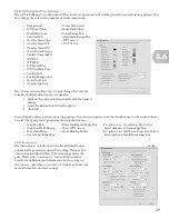
The ‘Layers’ tab allows VectorMap users the ability to manipulate and view maps, log files, and missions simultaneously
or have the option to move between different maps. VectorMap will display the map located highest in the map queue.
To manipulate the various layers, you may use the tool cluster at the bottom of the ‘Layers’ tab. First, click a file in the
panel to select it; then, use the tools to manipulate the file.
-Moves file down one step
-Add a new map file
- Moves files to the bottom
-Zoom to active mission
-Moves file up one step
-Provide detail of selected map
- Moves file to the top
-Remove file
- Zoom to view all maps
-Set mission to active
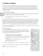
3.51 Overlay Multiple Maps
When you download and view a map in the primary screen area, VectorMap can
overlay another type of map (such as a topographic map over a satellite image) using
TerraServer and the ‘Layers’ tab. The first step is to download the map.
1. Click ‘Tools’ in the task bar.
2. Select ‘Download a Map.’
This displays the ‘Select Online Data Source to Download’ window. If you used
TerraServer to download the first map, simply repeat the steps you used to obtain
it but select another type that you desire to overlay (one of the seven options in the
‘Select Data Source’ window). If you obtained the first map from file, please refer to
Section 3.22 to learn how to obtain a map from TerraServer.
Once you download the maps that you intend to use, begin to overlay maps using the
‘Layers’ tab located halfway down the Tools panel on the right side of the window.
1. Click the ‘Layers’ tab.
2. The maps are designated with red flags under the ‘Maps Layers’ heading.
3. Identify the maps by hovering the pointer over each map heading.
Click in the control screen to ensure that the identification box appears
when you hover the pointer. The highest map in the map queue box is displayed on
the primary screen area. You can move map layers to bring different maps into view.
Utilize the ‘Layers’ function to overlay two maps of the same area in order to view
two sets of information on the region simultaneously. For example, to plan a mission
primarily using a DOQ satellite image with topographic information on top of the satellite image, use the satellite
image as a base map and overlay the topographical map.
NOTE
3.5