SonTek RS5 User Manual (August 2020) 117
Figure 107. Example of FlowPack Export .CSV File Format
8.7.5 KML
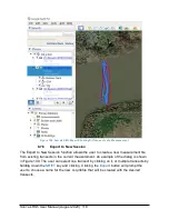
The KML export creates a .KML file containing the vessel tracks and automatically open
Google Earth if it is installed on the laptop. The user has the option to export only the
current transect or all transects in the measurement. Note that files will be geo-located
only if the RS5-Max (with GNSS/GPS option) is used. Bottom-track track lines will be
plotted starting at the same position as GNSS/GPS tracks. An example of the exported
tracks is shown in Figure 108. The individual transects and different track options can
be activated or deactivated using the left navigation pane in Google Earth.
Summary of Contents for Sontek River Surveyor RS5
Page 1: ...RS5 USER MANUAL XA00125...


