


The
MLHGT
product produced by IRIS is a depiction of the melting level heights on a
Cartesian map. The melting level heights are determined on a user defined grid providing an
illustration how the melting level heights changes geographically.
Dual Polarization radar data is used as input along with a priori information. As with other
IRIS products, the
MLHGT
product may be animated in time and overlayed with other data
to increase situational awareness of the precipitation structure in the atmosphere.
3.10.1 MLHGT Algorithm
IRIS dual polarization raw volume data is used as input for the
MLHGT
algorithm. This data
may come from either single
PPI
, volume,
RHI
, or sector scans. The algorithm also functions
independently from scan geometry matching data from the scan polar co-ordinate system
to an Earth relative co-ordinate system. However as with any radar observation, a higher
number of elevations in a volume scan provides the best results.
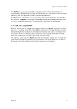
The following figure shows the
MLHGT
algorithm flow diagram. The top level illustrates the
radar observation inputs, followed by prior information. The blocks represent consecutive
functional steps. A key qualifier for each step is expressed in parenthesis.
Chapter 3 – Configuring IRIS Products
RESTRICTED
49
Summary of Contents for IRIS
Page 1: ...M211319EN H RESTRICTED User Guide IRIS Radar IRIS Product and Display...
Page 12: ...IRIS Product and Display User Guide M211319EN H 10 RESTRICTED...
Page 71: ...Chapter 3 Configuring IRIS Products RESTRICTED 69...
Page 303: ...Figure 103 Typical Spectrum Plot Appendix A Basic Radar Meteorology RESTRICTED 301...
Page 386: ......
Page 392: ......
Page 393: ......
Page 394: ...www vaisala com...