CP390i and CPF390i
Page 55
5. MAX CARTOGRAPHY OVERVIEW
5.0
BUILT-IN CHARTS
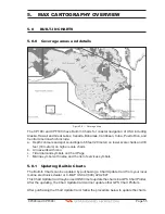
5.0.0 Coverage areas and details
Figure 5.0.1 - Coverage Area
The CP190i and CPF190i have Built-In Charts for coastal navigation of USA including
Alaska, Hawaii and Great Lakes, Canada, Bahamas, Caribbean, Cuba, Puerto Rico, and
Central America which include:
a. Depth contours and spot soundings to 66 feet (20 meter) on lower scale charts and 33
feet (10 meters) on higher scale charts
b. All nav-aids with icon
c. Tidal diamond symbols on Chart Page
1. Marina symbol with name and the list of services symbols
5.0.1 Updating Built-In Charts
The Built-In Charts can be updated by purchasing a Chart Update Card from your local
marine electronics dealer or C-MAP USA at (800) 424-2627.
This Chart Update Card may be used ONE time to update the charts in a GPS Chart Plotter.
After the updating, the Chart Update Card will not update other GPS Chart Plotters.
After purchasing the Chart Update Card, follow the procedure below to update the charts.
Summary of Contents for CP390i
Page 1: ......
Page 5: ...Page 6 CP390i and CPF390i ...
Page 15: ...Page 16 CP390i and CPF390i ...
Page 29: ...Page 30 CP390i and CPF390i ...
Page 43: ...Page 44 CP390i and CPF390i ...
Page 53: ...Page 54 CP390i and CPF390i ...
Page 67: ...Page 68 CP390i and CPF390i ...
Page 75: ...Page 76 CP390i and CPF390i ...
Page 83: ...Page 84 CP390i and CPF390i ...
Page 87: ...Page 88 CP390i and CPF390i ...
Page 109: ...Page 110 CP390i and CPF390i ...
Page 145: ...Page 146 CP390i and CPF390i Figure 17 16 C Card Restore settings ...
Page 147: ...Page 148 CP390i and CPF390i ...
Page 153: ...Page 154 CP390i and CPF390i ...
Page 157: ...Page 158 CP390i and CPF390i ...
Page 168: ......

