


Noggin
13-Survey & Map Mode
117
13.4 Noggin File Management
The File Management option is available by pressing 2 from the Survey & Map menu.
The File Management menu allows the user to create GPR Project (GPZ) and Google Earth
(KMZ) Files, delete data from the DVL and copy data from the internal compact flash drive to the
removable compact flash drive.
13.4.1 Creating GPR Project (GPZ) and Google Earth (KMZ) files
Individual data files created in Survey & Map mode are saved in Line (
13.1.1: p.75
) and Grid
(
13.1.2: p.76
) project folders.
The “Create GPZ/KMZ Files” option allows the user to save the data in Line and Grid project
folders to GPR Project (GPZ) files and, if a GPS was attached to the GPR system (
9: p.44
),
Google Earth (KMZ) files.
GPR Project (GPZ) files are files generated by compressing all the GPR data and support files in
a line or grid folder into a single file with the same name as the line or grid folder, for example,
Project0.GPZ or Grid7.GPZ. GPZ files are used by Sensors & Software data analysis software
like EKKO_Interp and EKKO_Project.
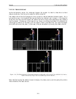
Google Earth (KMZ) are files that use GPS information to show, on the Google Earth PC
software, where a GPR data were collected (
Figure 13-14
).
Figure: 13-14 Google Earth (KMZ) files display where the GPR data lines were collected as well as Fiducial markers.
Summary of Contents for Noggin 100
Page 1: ...User s Guide Copyright 2012 Sensors Software Inc 2011 00022 02 Noggin ...
Page 2: ......
Page 4: ......
Page 8: ......
Page 17: ...Noggin 2 Noggin Components 3 Figure 2 3 Noggin 100 components ...
Page 156: ...Appendix D Instrument Interference Noggin D 2 ...
Page 158: ...Appendix E Safety Around Explosive Devices Noggin E 2 ...
Page 162: ...Noggin G 4 ...