


Richenpower Y25 AG Drone
User Manual
24
©
2022 Richenpower Copy Right
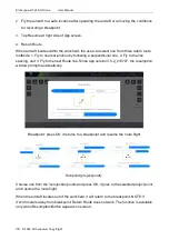
3. GNSS (Satellite number)
:
this icon shows the number of satellites connected. It should be greater than 20.
4. Control and Image Transmission Signal Strength
:
if this icon is red in Warning area, the remote controller is disconnected.
5. Obstacle Avoidance Function Status
Shows information on the detected obstacles when the obstacle avoidance function of the
radar module is enabled. Information regarding obstacles detected in front of the aircraft
appears on the top of the screen. The obstacle detected at the rear of the aircraft is
displayed at the bottom of the screen. Red, orange, and gray bars indicate the distance of
obstacles. The value indicates the distance between the aircraft and the nearest obstacles.
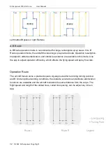
6. Field and Operation
:
Fields. The users can create, find and edit fields.
:①
Plan Area
– shows the total plan area value when planning fields or Route operations
via the intelligent operation planning system. Plan Area = Field Area
– Obstacle Area –
Collision Avoidance Safety Margin zone.
②
Sprayed Area
– shows the value of the area already sprayed during Route or A/B Route.
:
(Red) Obstacle Area
– shows the area value of the obstacles measured when planning
fields for Route operations.
:
shows land already covered. 15 MU = 1 Hectare. Tag this icon can set spray flow
rate and line spacing distance. The standard spray flow rate is 1.0 liter per MU. The