background image

Operator Manual

Raytheon Anschütz GmbH

Germany

R

ECDIS

8

7

3655DOC020102

Edition: 30.MAR.2007

8.2

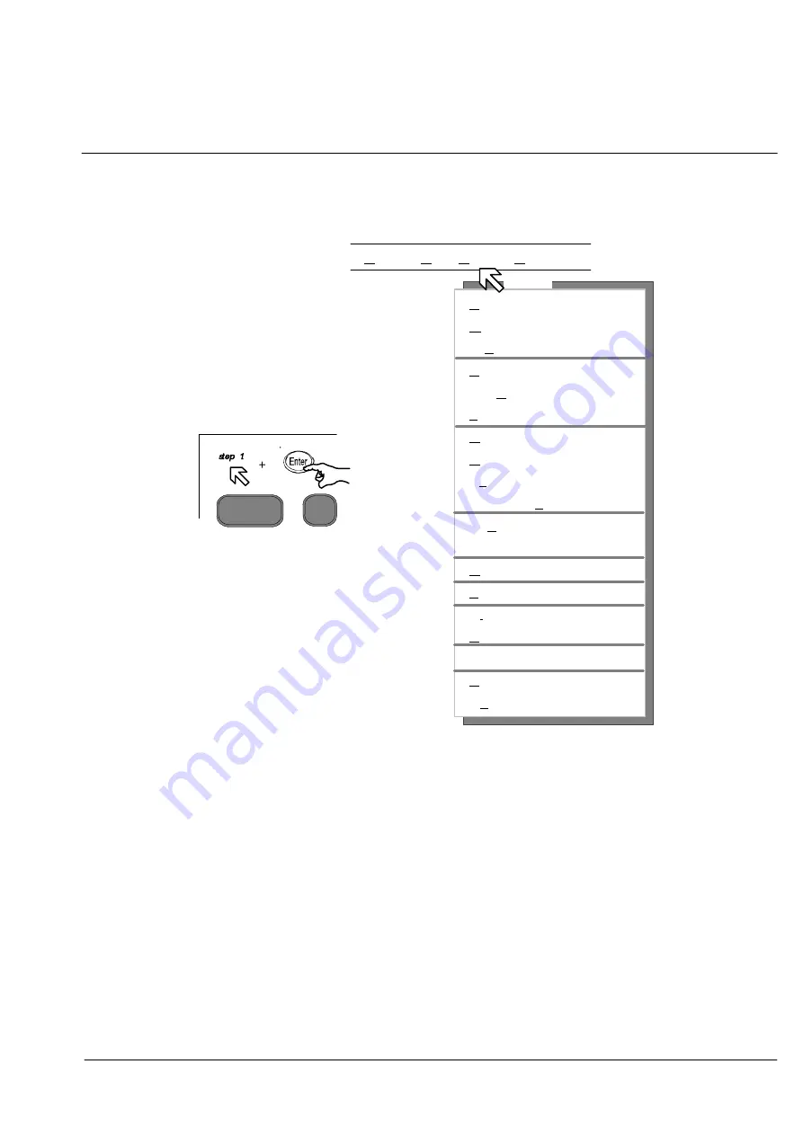
ROUTES MENU COMMANDS

Alt

R

via cursor

via keystroke

or

+

use the pull down menu

Edit Route...

"

Open Route...

"

Toggle Routes
Save Route...

"

Show Route...

"

List Route...

"

Clear Route...

"

Delete saved Route...
Export Routes...
Import Routes...
Send Route to Radar
Route Transfer
Route Monitoring...
Track Control...
Distance

To

Run...

Planned Position...
Pre

Departure Checklist...

Alarms...
Check Route...

Display

Step 1

Ship Routes Nav Tools

Figure: 1

5 Routes Menu

Summary of Contents for Pathfinder ECDIS

Page 1: ...Ansch tz GmbH Postfach 1166 D 24100 Kiel Germany Tel 49 4 31 30 19 0 Fax 49 4 31 30 19 501 Email Service raykiel com www raytheon anschuetz de 3655 DOC012 Edition 30 MAR 2007 PATHFINDER ECDIS OPERATO...

Page 2: ...re liable to the payment of damages Toute communication ou reproduction de ce document toute exploitation ou communication de son contenu sont interdites sauf autorisation expresse Tout manquement cet...

Page 3: ......

Page 4: ...al 1 1 4 Software Windows NT 4 0 or Windows 2000 Operating System ECDIS CD NB44 006 E 02 XX or E03 XX 1 2 Monitor C21 M28584 and or 1 3 Monitor C29 M28611 and or 1 4 Display TFT 19 JH 19 T02 MMD R1 1...

Page 5: ...2 1 2 Software Windows NT 4 0 or Windows 2000 Operating System ECDIS CD NB44 006 E 02 XX or E03 XX 2 2 1 ECDIS Control Panel G626398 1 2 2 2 ECDIS Operator Panel 948 016 NG001 2 3 Monitor C21 M28584 a...

Page 6: ...3 4 Connection module 948 012 NG001 for Processor 950 005 NG005 950 003 11 for Processor 950 005 NG001 3 5 Monitor C21 M28584 and or 3 6 Monitor C29 M28611 and or 3 7 Display TFT 19 JH 19 T02 MMD R1 3...

Page 7: ...chapter 5 3 add or delete chart symbols points lines and text add or delete chart data to or from a chart according to DNC Collars and Symbols shows the update history select different display modes...

Page 8: ...SHORT OPERATION Raytheon Ansch tz GmbH Germany R ECDIS 3655DOC0201 Edition 30 MAR 2007...

Page 9: ...3 2 1 4 Operator panel 2 4 2 1 5 ASCII Keyboard Techniques Option 2 6 2 1 5 1 Keystrokes 2 6 2 2 MENU BAR 2 7 2 2 1 Pulldown Menu 2 7 2 2 2 Menu Conventions 2 8 2 3 USING THE WINDOWS AND DIALOG BOXES...

Page 10: ...tude Longitude Boxes 2 20 2 3 9 1 Specify a Coordinate Using the Trackball 2 20 2 3 9 2 Specify a Coordinate Using the Keyboard 2 20 2 3 10 Plural Selection 2 21 2 3 10 1 Activate the Chart or Object...

Page 11: ...ion dialog box detailed information 4 18 4 4 2 Chart Alignment dialog box detailed information 4 21 4 5 LICENSE ADMINISTRATION FOR CM93 3 LICENSES 4 23 4 5 1 Add License manually 4 24 4 5 2 Expired Li...

Page 12: ...S MENU 5 1 5 1 OPTIONS MENU ARCS 5 1 5 1 1 Chart Information 5 2 5 1 2 View Chart Notes 5 2 5 1 3 Notices to Mariners and Warnings 5 3 5 1 4 Show Updates and ARCS Indicate Updates 5 3 5 2 OPTIONS MENU...

Page 13: ...Zooming In 6 3 6 1 1 2 Zooming Out 6 5 6 1 2 Default Scale 6 6 6 1 3 Largest Scale 6 6 6 1 4 Scale and Center Command 6 6 6 1 4 1 Change the Scale and Center of the Display 6 6 6 1 5 View Area Comman...

Page 14: ...ght ON or OFF 7 14 7 1 7 Placing Ship Marks 7 16 7 1 8 Anchor Watch 7 17 7 1 9 Guard Zone 7 18 7 1 10 Man Overboard 7 19 7 1 11 Clear or Cancel Man Overboard Alarm 7 21 8 ROUTES MENU 8 1 8 1 ROUTE PLA...

Page 15: ...ar 8 35 8 2 11 1 Send to Radar 8 35 8 2 11 2 Send Route to Radar 8 36 8 2 12 Route Monitoring 8 37 8 2 13 Track Control 8 39 8 2 13 1 Information Panel NAV Route Description 8 40 8 2 13 2 Information...

Page 16: ...ETA Calculation for One or More Legs 9 14 9 1 8 Tidal Prediction 9 16 9 1 9 Magnetic Variation 9 18 9 1 10 Distance To Run Planned Position 9 20 10 PLOT LAYER 10 1 10 1 PLOT LAYER COMMANDS 10 1 10 1...

Page 17: ...12 1 4 1 Label a radar target 12 16 12 1 4 2 Turning OFF all Target Trails 12 17 12 1 5 Driving an Autopilot 12 18 12 1 6 Integrating a Depth Sounder Setting the Depth Alarm 12 20 12 1 7 Changing the...

Page 18: ...Menu Bar Annex 2 and 2 1 Charts Annex 3 ARCS Chart Annex 4 S57 CMAP93 3 Annex 5 Charts S57 License Annex 6 Charts IHO S 63 Annex 6 1 Charts Installation S57 ARCS Annex 6 2 and 6 3 Charts Installation...

Page 19: ...PATHFINDER ST MK2 ECDIS ARE TRUE BEARINGS VS MAG NETIC OR COMPASS CANCEL THE CANCEL KEY OR CANCEL COMMAND BUTTON IT CANCELS A COMMAND CASCADING MENUS A SUB MENU THAT OPENS WHEN YOU SELECT A COMMAND FR...

Page 20: ...ARTH DIALOG BOXES RECTANGULAR BOXES DISPLAYED WHEN PATHFINDER ST MK2 ECDIS REQUIRES MORE INFORMATION BEFORE EXECUTING A COMMAND DIALOG BOXES ALSO DISPLAY WARNING MESSAGES AND OTHER INFORMATION DIGITIZ...

Page 21: ...G OPTIONS INCLUDE USER DEFINED TEXT THE CURRENT TIME OR SEQUENTIAL NUMBERS MENU A LIST OF COMMANDS MENU BAR AT THE TOP OF THE WINDOW THE BAR THAT CONTAINS THE APPLICATION S MENU NAMES MOB THE ABBREVIA...

Page 22: ...THE SAFETY OF LIFE AT SEA DEVELOPED BY IMO THE CONTRACTING GOVERNMENTS UNDERTAKE TO PROMULGATE ALL LAWS DECREES OR DERS AND REGULATION AND TO TAKE ALL OTHER STEPS WHICH MAY BE NECESSARY TO GIVE THE PR...

Page 23: ...R ECDIS XV 3655DOC020102 Edition 30 MAR 2007 Term Description WINDOW THE RECTANGULAR AREA IN WHICH MICROSOFT WINDOWSTM DISPLAYS PROGRAMS AND FILES XTE CROSS TRACK ERROR THE PERPENDICULAR DISTANCE BET...

Page 24: ...Operator Manual Table of Contents XVI 3655DOC020102 Edition 30 MAR 2007...

Page 25: ...ous shipboard sensors such as ARPA ra dar AIS information positioning devices and echo sounders and integrates the information into easily interpreted visual displays The ECDIS supports charts from go...

Page 26: ...lines drawn on the display These lines designate the different fragments of the paper charts You may view the source of the chart the chart name manufacturer date and much more by clicking the right m...

Page 27: ...ENC to SENC 1 1 2 Charting Capabilities for ENC The provision of a timely reliable worldwide uniform ENC data distribution ser vice is a major organizational challenge The IHO developed the WEND Worl...

Page 28: ...ry purpose ENCs are to be distributed in the encapsulation described in the S57 Standard However such plain S57 en capsulated ENCs may become easily subject to unauthorized amendment or ille gal copyi...

Page 29: ...eographically coordinates are displayed after selection by courser on the Information Panel Other for seacharts typically information as there are buoys light beacons wrecks or depth information can o...

Page 30: ...Operator Manual 1 6 3655DOC020102 Edition 30 MAR 2007...

Page 31: ...ORGANIZATION Menu Bar see chapter 2 2 Tool Bar see chapter 2 4 Cursor see chapter 2 5 Information Panel see chapter 2 7 Chart Area see chapter 2 9 Status Bar see chapter 2 8 Trackball see chapter 2 1...

Page 32: ...minating the ECDIS see chapter 2 1 2 D How to use the CURSOR see chapter 2 1 3 D How to handle the OPERATOR PANEL see chapter 2 1 4 2 1 1 Starting the ECDIS Positioned on front lower right side Pressi...

Page 33: ...as the Enter key There are two trackball techniques that you will use when working with ECDIS Point and click Using the trackball place the cursor e g over a command from the menu bar and press the b...

Page 34: ...ECDIS operating 1 6 Status indicators press toggle switch 7 The function activated is indicated by Use the dial 16 to adjust the Gain Use the dial 11 to adjust the Sea The Gain control adjusts the sen...

Page 35: ...t EBL Use the dial 16 to adjust VRM 7 Toggle switch Can be switched between upper position Gain Sea and lower position VRM EBL See status indicators 1 6 and use dial 16 or dial 11 8 Toggle switch Rang...

Page 36: ...hold it down S Press the underlined letter in the menu name S Press the underlined letter in the command name Each Menu Command contains a letter that is underlined e g Plot Simultaneously pressing th...

Page 37: ...ng the Keyboard Command Alt and the underlined letter invokes the function i e Pressing Alt and the letter D on the Keyboard invokes the Display menu Simultaneously pressing the Alt and the letter D f...

Page 38: ...ctive Selecting the command again turns it off and the check mark disappears 3 Accelerator Keystroke s Without opening the menu you can activate the command using the keystroke s shown 4 Grayed comman...

Page 39: ...S software On selecting an editing field a context related keyboard see Figure 1 7 appears The operation is effectied via trackball prepared for editing a numerical values only prepared for editing La...

Page 40: ...Point to any part of the screen outside the menu and click Closing a Menu with the Keyboard Press Esc 2 3 2 Using Dialog Boxes When you activate a command followed by an ellipsis ECDIS displays a dial...

Page 41: ...ny different areas option buttons text boxes scroll bars check boxes command buttons and list boxes You will use these areas to provide the information ECDIS needs to execute a command For example whe...

Page 42: ...also be highlighted i e darkened 2 3 3 1 Moving the Focus Rectangle dotted box with Trackball Point and click on the desired area or item 2 3 3 2 Moving the Focus Rectangle dotted box with Keyboard 1...

Page 43: ...anges without closing the dialog box Command buttons are labeled according to the action they carry out Save or Open for example Selecting a command button is usually the last action you will take whe...

Page 44: ...ight side of the box Use the scroll bar to move the list up or down until hidden items become visible These scroll bars can be activated with the trackball or with the directional keys on your keyboar...

Page 45: ...eyboard 1 Press Tab until one of the items in the list box usually the first item is outlined with the focus rectangle dotted box 2 Use the arrow or the PgUp PgDn keys to move up and down the list Sto...

Page 46: ...ext Boxes View Area Some text boxes have spinners next to them see Figure 1 14 By clicking on the arrows you can increase or decrease the value in the text box Spinners Figure 1 14 Text Boxes Echosoun...

Page 47: ...6 2 Entering Information in a Text Box with Keyboard 1 Press Tab until the cursor appears in the text box If the box already contains text the text appears highlighted Unless you reposition the cursor...

Page 48: ...ion Buttons Figure 1 15 Option Buttons 2 3 7 1 Select or Clear an Option Button with Trackball Point and click on the option button or its label 2 3 7 2 Select or Clear an Option Button with Keyboard...

Page 49: ...e box is empty Check Boxes Figure 1 16 Check Boxes 2 3 8 1 Selecting Clearing a Check Box with Trackball Point and click on the check box or its label 2 3 8 2 Selecting Clearing a Check Box with Keybo...

Page 50: ...ox then type the degrees NOTE If the text box currently contains a value that you want to change click on that text then type the correct value 3 Click in the Minutes text box then type the minutes If...

Page 51: ...If you want to copy more than one Object Group to Floppy 1 Press and continue to hold down the the Control button 2 Point to the first name GIBRALTAR press the Left button Trackball Point to the seco...

Page 52: ...Charts object causes the Chart Objects dialog box to appear It displays a list of objects located on the chart within the area at which you pointed the cursor You may then point and click Left on eac...

Page 53: ...1 21 Figure 1 21 Object info for S 57 chart format Select an Object and Send to Radar Objects with special info e g coastline or restricted area activates the Send to Radar button in the Object Info...

Page 54: ...Operator Manual 2 24 3655DOC020102 Edition 30 MAR 2007 Figure 1 22 Object info and Send to Radar function Information in tif format Information in txt format Figure 1 23 Special object infos...

Page 55: ...location Please see The Zoom Feature chapter 6 1 1 4 Zoom Out Redraws the current view at a scale one and one half times larger Please see The Zoom Feature chapter 6 1 1 5 Center on Ship Centers the d...

Page 56: ...Select Chart Opens the Select Chart dialog box allowing you to select view a different chart for the area 11 MOB Starts the Man Overboard process Please see Man Overboard chapter 7 1 10 12 Standard Di...

Page 57: ...ault it remains in Center on Cursor mode unless a command is being performed Depending on the command being performed the cursor changes into one of the following shapes and enters one of the followin...

Page 58: ...ship cannot be drawn in its relative size It is also used during dead reckoning simulation It has a directional arrow displaying the ship s heading as well as a perpendicular shipboard line marking p...

Page 59: ...dder Position sensor as well as optional secondary position sensors such as Loran C The information is integrated into the information panel and graphical displays which allow the navigator to interpr...

Page 60: ...s current speed through water displayed in knots Speed BT The ship s current speed over ground displayed in knots 4 Weather Wind Speed and Direction over Ground what the wind is doing if you are stand...

Page 61: ...f the mode in which you are currently operating Mode selection is made by using the Steer Manually Steer to Track or Steer to Course Heading menu commands under the Waypoint menu You may transit betwe...

Page 62: ...Manual Steering mode in the following situations When you select the Steer Manually command from Steering Mode Selector Switch 2 Steering Mode Track Control Defined by an open route with established...

Page 63: ...ading the information panel will or say Heading Control When a course or heading is entered the ship will continue following the entered course heading for 100NM or until a different mode of operation...

Page 64: ...on black background Figure 1 33 Track Control Warning Message When a message is triggered ECDIS beeps to notify you that a message is being displayed You may either Acknowledge the message or silence...

Page 65: ...ell as the estimated time of arrival at that location assuming the ship s current speed and a direct route to that location The right hand corner box depends on the menu command you are currently perf...

Page 66: ...play menu The ECDIS supports charts from government agencies S57 DNC and ARCS and private chart manufacturers like C MAP Please consult your dealer for the availability of charts in your area NOTE All...

Page 67: ...ge scale Z background small scale A overview B general C coastal D approach E harbor F berthing G These navigational purposes are extensions to S57 3 Where an overlapping between two charts into the s...

Page 68: ...ow and search light the cone shape are displayed projecting from the bow of the ship symbol The information panel constantly displays updated information on your position speed and bearing NOTE The an...

Page 69: ...processing all other sensor inputs you cannot interact with ECDIS while printing takes place The Main menu contains the following commands Figure 3 1 via cursor via keystroke or Main Charts S 57 Opti...

Page 70: ...the drop down list Step 2 Select either a portrait or landscape paper orientation Step 3 Click on OK Step 1 Step 2 Step 3 Figure 3 2 Print Setup Dialog Box 3 1 2 Print Procedure Step 1 To print the pl...

Page 71: ...ep 1 Step 3 Step 2 Display Menu Figure 3 3 Print Options Dialog Box 3 1 3 Exit NOTE Do not exit from ECDIS by turning off the computer This may cause to loose plot data or may damage your system Proce...

Page 72: ...Operator Manual 3 4 3655DOC020102 Edition 30 MAR 2007...

Page 73: ...t Info Select S57 CM93 3 Chart Catalog Digitization License Installation Updates Step 1 Figure 4 1 Chart Menu Table 4 2 Overview Chart Menu Charts Commands Function 4 2 Goto ARCS or Goto S57 Toggles b...

Page 74: ...mmands Function 4 8 CM93 3 or IHO S63 4 9 ARCS 4 10 DNC Installation 4 11 S57 and CM93 3 4 12 ARCS 4 13 DNC Updates 4 14 Chart Server Rights Option Allows you to take over the Chart Server Rights Char...

Page 75: ...R ECDIS 4 3 3655DOC020102 Edition 30 MAR 2007 4 2 GOTO ARCS OR GOTO S57 If the two chart types are stored on the ECDIS Procedure Step 1 Select Goto ARSC Chart or Goto S57 Chart Result The ECDIS switch...

Page 76: ...into a continuous coverage The following scale layers are defined 1 Background small scal 2 Background medium scale 3 Overview 4 General 5 Coastal 6 Approach 7 Harbor 8 Berthing Where an overlapping b...

Page 77: ...e marked in green Step 5 Point and click on the chart you wish to view inside the hatched box You may need to zoom in in order to see the individual charts NOTE You may receive a message which states...

Page 78: ...talog Digitization License Installation Updates Step 2 Step 3 Step 4 Step 5 Step 6 Step 1 Figure 4 2 Select Chart Dialog Box S57 CM93 3 Command Buttons View Click on View to view the chart and leave t...

Page 79: ...ep 1 Select Charts menu bar Step 2 Select Info Select The Dialog Box appears Step 3 Select DNC Step 4 Point and click on the different chart types i e Harbor Coastal etc In order to see all of your ch...

Page 80: ...hart Catalog Digitization License Installation Updates Step 2 Step 5 Step 1 Step 3 Step 4 Figure 4 3 Select Chart Dialog Box DNC Command Buttons View Click on View to view the chart and leave the dial...

Page 81: ...al update service of the ARCS seacharts is ensured by the manufacturer A seachart in raster data format is divided into pixels and then stored On the screen of the ECDIS these pixels will be displayed...

Page 82: ...edure Step 1 Select Charts menu bar Step 2 Select Info Select The Dialog Box appears Step 3 Select ARCS Goto ARCS Chart Info Select S57 CM93 3 Chart Catalog Digitization License Installation Updates S...

Page 83: ...t a double click onto the respective chart S The last used charts listed in the box S Select by Position In this case position coordinates longitude latitude can be input either manually or directly b...

Page 84: ...anual 4 12 3655DOC020102 Edition 30 MAR 2007 Command Buttons View Click on View to view the chart and leave the dialog box open View and Close Click on View and Close to view the chart and close the d...

Page 85: ...a cell name the cell information appears Step 3 Select Goto Cell in order to center the selected cell on the display Step 4 By selecting the check box the cell boundary is highlighted Step 1 Step 2 S...

Page 86: ...3655DOC020102 Edition 30 MAR 2007 Figure 4 6 Update Status of a Database Export List Click on Export List to save the content of the left list box as a text file on a floppy If no disk is available Fi...

Page 87: ...ual Raytheon Ansch tz GmbH Germany R ECDIS 4 15 3655DOC020102 Edition 30 MAR 2007 Goto Cell Click on Goto Cell in order to center the displayed chart the selected cell Close Click on Close for closing...

Page 88: ...uck at the Chart Digitization Station this function allows the user to mark object coordinates anchoring grounds fishing grounds etc on the paper sea chart and have them displayed on the ECDIS Drawing...

Page 89: ...heon Ansch tz GmbH Germany R ECDIS 4 17 3655DOC020102 Edition 30 MAR 2007 Enter New Alignment see chapter 4 4 2 Step 1 Step 2 Step 3 Step 2 Step 4 detailed information Figure 4 8 How to use the digiti...

Page 90: ...Depth Units is the units used by the paper chart manufacturer for depth soundings The ECDIS only supports Meters Fathoms and Feet for units of depth soundings The appropriate Depths Units button must...

Page 91: ...reference datum that was used for the creation of the paper chart The ECDIS support all datums in IHO S 60 The Datum selected must be obtained directly from the paper chart being described If the dat...

Page 92: ...n the pull down datum list If the paper chart being described was created with a datum other than one of the listed datum and an offset to WGS 84 datum is provided on the paper chart then an offset ca...

Page 93: ...wing sections describe the fields and where to obtain the information to properly fill in the fields during the alignment process Figure 4 10 Chart Alignment dialog box Secure Paper Chart The paper ch...

Page 94: ...s latitude and longitude crossing point The latitude of this third alignment point must be the same latitude as the second crossing point Left click the puck Only the longitude of the third point will...

Page 95: ...ame on the right side of this box and type the corresponding license string into the appropriate box The user has the option of subscribing to or purchasing licenses In case of subscription licenses a...

Page 96: ...anually Step 4 Enter the License key 16 characters via OSK Step 5 The procedure must be confirmed via the Add license key Step 6 Select a Zone or a Zone Area The Zone or the Areas are released and sho...

Page 97: ...xpire by a certain date in the future Procedure see Figure 4 12 Step 1 and Step 2 see Figure 4 11 Step 3 Select Expired licenses Step 4 Enter the desired date with the format Month Year via OSK Step 5...

Page 98: ...d and displayed with the following information valid to e g 10 2002 Zone Area 16 character license code Procedure see Figure 4 13 Step 1 and Step 2 see Figure 4 11 Step 3 Select License list All the l...

Page 99: ...desired area at least three coordinates must be set by action The position data of the coordinates are entered in the list box Coordinates per mouse click in order Step 4 After a final calculation lic...

Page 100: ...s process the default chart type is taken into account Command buttons in the Chart collection area The result of the calculation is displayed in this List Box In this connection the Zone is displayed...

Page 101: ...0009 usr Yes No ECDIS Step 1 This window displays the imminent data transfer to the target directory a and the name of the license file e g RaytheonAnsch tz Step 1 The action is executed by pressing...

Page 102: ...In this process the license folder is determined by the chart type assignment Procedure see Figure 4 15 Step 1 and Step 2 see Figure 4 11 Step 3 Select Order per position by using the Trackball mouse...

Page 103: ...the charts that were recorded via the route In this process the default chart type is taken into account Command buttons Chart collection for selected route area The calculated charts are listed with...

Page 104: ...the imminent file transfer to the target directory a and the name of the license file e g Raytheon Ansch tz Step 1 The action is executed by pressing the Yes key Send this floppy to the chart manufac...

Page 105: ...red areas for a limited period Procedure see Figure 4 16 Step 1 and Step 2 see Figure 4 11 Step 3 Select Add license from file by using the Trackball mouse Insert the relevant medium into the appropri...

Page 106: ...02 Edition 30 MAR 2007 Command button Add licenses Within the List Box License file list all licenses are overlaid when the key is pressed At the same time the licenses are processed within the progra...

Page 107: ...Zone e g 3 are removed from the License order list when the entire Zone 3 is selected Procedure see Figure 4 17 Step 1 and Step 2 see Figure 4 11 Step 3 Select Order manually Step 4 Select a e g Zone...

Page 108: ...deletes all entries from the List Box in sequence Clear list deletes all entries from the List Box Create creates a license file from the List Box For this data transfer a formatted floppy must first...

Page 109: ...User Permit Procedure see Figure 4 18 Step 1 Select Chart menu bar Step 2 Select IHO S63 License Step 3 Select User Permit The Registration No is indicated in the field Step 1 Step 3 Goto ARCS Chart I...

Page 110: ...Licenses list Licenses can be renewed and the status of the current license list reviewed Step 3 Status information Step 3 Figure 4 19 License dialog box Licenses list selected Command Buttons Delete...

Page 111: ...e 4 20 Step 1 and Step 2 see Figure 4 18 Step 3 Select Add Licenses from file Licenses can be added automatically by choosing Add licenses from file and pointing to the ENC PMT file received from IHO...

Page 112: ...re see Figure 4 21 Step 1 and Step 2 see Figure 4 18 Step 3 Select Product list The product list shows all available IHO S63 charts If you want to order a new license please note the Cell code and con...

Page 113: ...updates or new chart cells IHO S63 include a second data file with a new product list Procedure see Figure 4 22 Step 1 and Step 2 see Figure 4 18 Step 3 Select Import Product list The new product lis...

Page 114: ...have no Security Key software dongle loaded before the License Administrator dialog box appears at first Follow the text items in the dialog box Step 4 Start the identification check Step 1 Step 3 Got...

Page 115: ...Buttons License Info Shows the License Information In this case the user permit data file can be copied automatically on a floppy disk Figure 4 24 ARCS License Information Load Permit file Select thi...

Page 116: ...Operator Manual 4 44 3655DOC020102 Edition 30 MAR 2007 Add Permit Select this button when you get a new License or an License Update per phone or fax Figure 4 26 Add Permit...

Page 117: ...re and click on the Remove Permit button Practice If you got a license update sometime a chart permit cancelled and replaced by another chart number Read SCHEDULE A AMENDMENT CHART SUPPLY DETAILS from...

Page 118: ...buys licenses for the charts All other charts are stored on the CD ROM in encrypted in S57 format meaning that the user has to buy licenses to access and display them Each license corresponding to on...

Page 119: ...DOC020102 Edition 30 MAR 2007 S57 and CM93 3 Installation ARCS Installation DNC Installation Goto ARCS Chart Info Select S57 CM93 3 Chart Catalog Digitization License Installation Updates Step 1 Step...

Page 120: ...es If no CD is available a dialog box appears follow the text item or Cancel this function Dialog Box Area Administration In the Administration area you can see available charts The n symbol indicates...

Page 121: ...tion Exit the dialogue box is faded out Cancel a current procedure is aborted Import and Convert unencrypted S57 data files Insert the data CD into the CD drive and select Import unencrypted The follo...

Page 122: ...he program recognizes and selects all cells in a selected directory subdirectories included These cells will be imported Procedure see Figure 4 31 Step 1 Step 2 Step 3 see Figure 4 29 Step 4 Select th...

Page 123: ...on In this case only the manually selected cells will be imported without subdirectories Procedure see Figure 4 32 Step 1 Step 2 Step 3 see Figure 4 29 Step 4 Select the folder S57 e g US Step 5 Selec...

Page 124: ...0102 Edition 30 MAR 2007 Starting the conversion process Procedure see Figure 4 33 Step 1 Select the Execute button The dialog box File conversion in progress appears and shows the processing Step 1 F...

Page 125: ...u want to see the complete installation information then select View Log Step 2 The following dialog window appears Note If the following message appears Following cells were not installed XXXXXXXXXX...

Page 126: ...4 54 3655DOC020102 Edition 30 MAR 2007 Insert the data CD into the CD drive and select Import IHO S 63 The following dialog will be displayed Select the CD drive and the directory where the S57 data i...

Page 127: ...ection In this case the program recognizes and selects all cells in a selected directory and subdirectories These cells will be imported Procedure see Figure 4 37 Step 1 Step 2 Step 3 see Figure 4 29...

Page 128: ...e only the manual selected cells will be imported without subdirectories Procedure see Figure 4 38 Step 1 Step 2 Step 3 see Figure 4 29 Step 4 Select the cell folder containing the datafile you wish t...

Page 129: ...ECDIS 4 57 3655DOC020102 Edition 30 MAR 2007 Starting the conversion process Procedure see Figure 4 39 Step 1 Select the Execute button The dialog box File conversion in progress appears and shows the...

Page 130: ...omplete installation information then select View Log Step 2 The following dialog window appears Note If the following message appears Following cells were not installed XXXXXXXXXX That means The char...

Page 131: ...ect Installation Step 3 Select ARCS Installation The volume list shows already installed zones Place an ARCS chart CD into the CD drive S57 and CM93 3 Installation ARCS Installation DNC Installation A...

Page 132: ...n If available the provided Update should be installed now The update process is also initiated by clicking on the Install Volume button see chapter 4 12 Remove Volume Click on this button if you want...

Page 133: ...edure see Figure 4 45 Step 1 Select Charts menu bar Step 2 Select Installation Step 3 Select DNC The volume list shows already installed zones S57 and CM93 3 Installation ARCS Installation DNC Install...

Page 134: ...e button and follow instructions see following dialog The installation will be take approximately 1 hours Procedure Step 1 Select the correct partition containing the CD and the right path Step 2 Sele...

Page 135: ...cation is running If the verification is done a summary will be displayed in the window In case of errors or warnings the corresponding messages will be shown in the report window Report messages In c...

Page 136: ...p 1 Step 1 Figure 4 49 Database registered Procedure see Figure 4 50 Step 1 Step 2 Step 3 see Figure 4 45 Step 4 For activation of installed DNC database the check mark has been placed before the data...

Page 137: ...e you will have displayed first or last and click Priority Up or Down Remove Database To remove a selected database click on Remove Data base Before the program deletes the selected database a safety...

Page 138: ...4 51 Step 1 Select Charts menu bar Step 2 Select S57 Updates The Dialog Box appears Step 3 Select the chart type Goto ARCS Chart Info Select S57 CM93 3 Chart Catalog Digitization License Installation...

Page 139: ...d by the function Get List before Create Order Insert a disk into the selected drive and select Create Order An order file will be written on the disk The name of the order file is the name of the dat...

Page 140: ...In this context the update will be done by floppy disk or CD ROM disk Insert the disk into corresponding drive Select the disk icon in the dialog box by cursor Open the following folders look for cor...

Page 141: ...rea related date of this zone are erased Inside a Review window all applied updates are displayed relative to their designated folders The designation of the version number has been changed by this pr...

Page 142: ...Operator Manual 4 70 3655DOC020102 Edition 30 MAR 2007 Figure 4 53 Updating Log Review Updates...

Page 143: ...ure see Figure 4 54 Step 1 Select Charts menu bar Step 2 Select Updates Step 3 Select ARCS Updates The volume list shows already installed zones Place an ARCS chart CD into the CD drive Goto ARCS Char...

Page 144: ...button the installation process starts see Figure 4 55 The ECDIS system checks the update edition If the edition is older than the actual ECDIS edition the following window appears update in progress...

Page 145: ...RCS chart all updates are entered and selected automatically To display the updates the functions ARCS Show Updates and ARCS Indicate Updates should be selected with the cursor ARCS Update select this...

Page 146: ...cedure see Figure 4 58 Step 1 Select Info Select Step 2 Select ARCS Main Charts S 57 Options displays the date of the published update Goto ARCS Chart Info Select S57 CM93 3 Chart Catalog Digitization...

Page 147: ...already installed zones Place an ARCS chart CD into the CD drive Select the location of the VDU Vector Product Database Update source and the DNC Database you want to use for this Update process Selec...

Page 148: ...g database from DNC DATABASE window Then click on the Apply Up date button If you want to install all available updates you only have to select corresponding DNC database and click on the Apply All Up...

Page 149: ...result of the updates installation process will be shown in the Processing Update window Figure 4 62 Execute DNC Update If you want to see what happens Procedure see Figure 4 63 Step 1 Select Show Rev...

Page 150: ...e e g Buoy in the chart Procedure see Figure 4 63 Step 1 Select e g on Relocate Buoy NT from 34 345 77 63 to 34 3333 Step 2 Select Highlight The chart will be centered automatically to the object and...

Page 151: ...tion Installation and Updates Client means The sea chart can only be preset by installing the Chart Server Rights accordingly License The Chart License is to be entered on each unit independent of the...

Page 152: ...Operator Manual 4 80 3655DOC020102 Edition 30 MAR 2007...

Page 153: ...View Chart Notes Notices to Mariners General Notices to Mariners Chart Warnings Show Updates Indicates Updates n Step 1 Figure 1 1 Option Menu Table 5 1 Overview ARCS Options ARCS Options Commands Fu...

Page 154: ...e 1 2 Step 1 Select ARCS Option see Figure 1 1 Step 2 Select Chart Information The Dialog Box appears Figure 1 2 Chart Information 5 1 2 View Chart Notes Within this menu ARCS chart notes of the curre...

Page 155: ...then displayed in grey 5 1 4 Show Updates and ARCS Indicate Updates Chart updates always refer to a complete chart In order to get an over view about all official updates as quickly as possible the en...

Page 156: ...tation Library Select from Presentation Libraries for S57 display the Test PL or Chart 1 including color differentiation diagram 5 2 2 Add Delete Mariner s Objects Add or delete chart symbols points l...

Page 157: ...1 Presentation Library With this menu item the user can select from different presentations for the currently loaded chart S57 In accordance with IHO S52 Specifications of Chart Content and Display A...

Page 158: ...fications for ECDIS handbook Procedure see Figure 1 6 Step 1 Select Presentation Library The Dialog Box appears Step 2 Select Chart1 A information window appears Select OK the Presentation Library Lis...

Page 159: ...020102 Edition 30 MAR 2007 OK Cancel Step 2 Step 3 Step 4 Step 5 Figure 1 6 Information window Problem solution If you cannot recognize any line adjust more Contrast Brightness If the picture has not...

Page 160: ...ect an Object Step 4 Specify the representational form of a object within the chart If the object has not been assigned to a clear representational form one of the forms offers Point Line or Area can...

Page 161: ...descriptions for this object via scroll bar Step 3 Step 5 Step 5 1 Step 4 Step 6 Figure 1 7 Add Delete Mariners In this case it is possible to specify a buoy with more details Buoys with special purp...

Page 162: ...MAR 2007 Step 7 Figure 1 8 Edit Manual Objects dialog box By pressing the Close key the cursor is released for positioning the buoy The positioned buoy is displayed within the light cone code within t...

Page 163: ...tion with Type of object Line or Area selected The line or area planning must be finished by clicking on the Add Object button Delete Objects On actuating this button the Delete functions are activate...

Page 164: ...5 and in the text box from the Object info window Procedure see Figure 1 11 Step 1 Select S 57 Option see Figure 1 1 Step 2 Select Manual Updates The Dialog Box appears see Figure 1 11 Step 3 Select a...

Page 165: ...te descrip tions if possible for this object via scroll bar Step 3 Step 4 Step 5 Step 5 1 Step 6 Figure 1 11 Manual Updates In this case it is possible to specify a buoy with more details Buoys with s...

Page 166: ...AR 2007 Step 7 Figure 1 12 Edit Manual Objects dialog box By pressing the Close key the cursor is released for positioning the buoy The positioned buoy is displayed within the light cone code within t...

Page 167: ...Objects This function is applied in connection with Type of object Line or Area selected The line or area planning must be finished by clicking on the Add Object button Delete Objects On actuating thi...

Page 168: ...ctuating this button you can select the object using the appropriate symbols like and Procedure see Figure 1 15 Step 1 Select the desired object The Object Info window appears Step 2 Select the Object...

Page 169: ...information of the scale ranges must be updated after deletion or addition After the deletion insertion of an object the following steps are recommended Select View all chart it will display the updat...

Page 170: ...gend This menu feature opens an Info Window for the currently loaded chart The Info Window shows all characteristic data specific for S57 charts Procedure see Figure 1 16 Step 1 Select S 57 Options se...

Page 171: ...Step 1 Select S57 Options see Figure 1 1 Step 2 Select View Log File The Dialog Box appears Respective Log File can be viewed directly or if a printer is connected be printed Automatic Updates Manual...

Page 172: ...ct Overlays The Dialog Box appears Figure 1 18 S57 Overlays Base Display permanently retained on the ECDIS display consisting of 1 coastline high water 2 own ship s safety contour to be selected by th...

Page 173: ...aticule 6 place names User defined Display This functions allows to restore the user defined display settings by a single operator action See S57 Chart Options using the command button Save settings a...

Page 174: ...of the Safety depth can be linked to the Safety contour by using the corresponding check box Commond Button Save settings as User defined Display The button is used to store all currently made settin...

Page 175: ...ed navigational purpose e g harbour approach Procedure see Figure 1 20 Step 1 Select S57 Options see Figure 1 1 Step 2 Select Overlays The Dialog Box appears Figure 1 20 CMAP 93 3 Chart Scale Example...

Page 176: ...buoys and beacons can be displayed either as Simplified Symbols according to IHO paper S52 Procedure see Figure 1 21 Step 1 Select S 57 Options see Figure 1 1 Step 2 Select Symbol Type The Dialog Box...

Page 177: ...s Function 5 3 1 Add Delete Mariner s Objects Add or delete chart symbols points lines and text 5 3 2 Manual Updates Add or delete chart data to or from a chart according to DNC Collars and Symbols 5...

Page 178: ...ear representational form one of the forms offers Point Line or Area can be selected Step 5 Specify the object Attributes For each object a list of attributes is provided An object can only be positio...

Page 179: ...dd Delete Mariners In this case it is possible to specify a buoy with more details Buoys with special purpose Light only The Edit Manual Object window is displayed only if the selected object has addi...

Page 180: ...lose key the cursor is released for positioning the buoy The positioned buoy is displayed within the light cone code within the chart Figure 1 25 Add a special object info Command Buttons Undo Edit Th...

Page 181: ...st be finished by clicking on the Add Object button Delete Objects On actuating this button the Delete functions are activated This process is recorded within the View Log File List see chapter 5 2 5...

Page 182: ...and in the text box from the Object info window Procedure see Figure 1 27 Step 1 Select DNC Option see Figure 1 1 Step 2 Select Manual Updates The Dialog Box appears see Figure 1 27 Step 3 Select an...

Page 183: ...te descrip tions if possible for this object via scroll bar Step 3 Step 4 Step 5 Step 5 1 Step 6 Figure 1 27 Manual Updates In this case it is possible to specify a buoy with more details Buoys with s...

Page 184: ...lose key the cursor is released for positioning the buoy The positioned buoy is displayed within the light cone code within the chart Figure 1 29 Add a special object info Command Buttons Undo Edit Th...

Page 185: ...Delete Objects On actuating this button the Delete functions are activated Procedure see Figure 1 30 Step 1 Select the desired object The Object Info window appears Step 2 Select the Object Attribute...

Page 186: ...see Figure 1 31 Step 1 Select the desired object The Object Info window appears Step 2 Select the Object Attribute The object gets a circle as an overlay marker Step 3 Select the Move Object button A...

Page 187: ...information of the scale ranges must be updated after deletion or addition After the deletion insertion of an object the following steps are recommended Select View all chart it will display the updat...

Page 188: ...dow shows all characteristic data specific for DNC charts Procedure see Figure 1 32 Step 1 Select DNC Options see Figure 1 1 Step 2 Select Legend If you have only 1 database loaded the database name i...

Page 189: ...sch tz GmbH Germany R ECDIS 5 37 3655DOC020102 Edition 30 MAR 2007 This Warning will be displayed if the coefficients for the World Magnetic Model are out of date see Section see chapter 9 1 9 Figure...

Page 190: ...tive Log File can be viewed directly or if a printer is connected be printed Automatic Updates Manual Updates Marine Objects Automatic Update Manual Update Mariner Update Figure 1 34 Legend Command Bu...

Page 191: ...contour to be selected by the mariner 3 indication of isolated underwater dangers of depths less than the safety contour which lie within the safe waters defined by the safety contour 4 indication of...

Page 192: ...he corresponding check boxes The availability of the check box groups depends on the pre selected chart feature set Base Display Standard Display Full Display The values for 3 different depth contour...

Page 193: ...Operator Manual Raytheon Ansch tz GmbH Germany R ECDIS 5 41 3655DOC020102 Edition 30 MAR 2007 Figure 1 36 Option Menu...

Page 194: ...buoys and beacons can be displayed either as Simplified Symbols according to IHO paper S52 Procedure see Figure 1 37 Step 1 Select S 57 Options see Figure 1 1 Step 2 Select Symbol Type The Dialog Box...

Page 195: ...return to it In addition you can use the Ship Auto Center feature or the directional keys to scroll the display and ensure that your ship is always in view The information panel to the right of the d...

Page 196: ...p Auto Center Automatically repositions the display so that Own ship returns to the center when it reaches a user defined distance from the edge of the display 6 1 7 True Scale Icon Own ship symbol wi...

Page 197: ...ual size 3 The vertical scale of the chart and the ratio at which the display chart can be viewed in order to be at scale 4 Indicates the current overlay status Base Display Standard Display Full Disp...

Page 198: ...n the box to the desired size but want to reposition it before you release the Enter button hold down Shift and move the cursor until the box is in the desired position The box remains the same size w...

Page 199: ...command does not affect the center of the display Select Zoom Out from the Display menu or press the Zoom Out key on the toolbar Procedure Step 1 Select the display menu see Figure 1 1 Step 2 Select...

Page 200: ...ter of the Display Procedure Step 1 Select the display menu see Figure 1 1 Step 2 Select Scale and Center The dialog box appears The current display center appears in the Latitude and Longitude boxes...

Page 201: ...d center on a specific chart that you have named and saved You will find the View Area feature especially helpful if there are certain geographic regions you display frequently When you change the are...

Page 202: ...tom of the dialog box If there are no areas listed the scale and center of the current display is shown Step 3 Step 3 Figure 1 6 View Area dialog box 6 1 5 1 Save an Area Procedure Step 1 Select the d...

Page 203: ...The dialog box appears Step 3 Click on the name of the area you want to open The area name appears in the text box and its scale and center appear below the list box Step 4 Click on Open 6 1 5 3 Dele...

Page 204: ...see it To locate your ship simply turn on Ship Auto Center or click the Center on Ship button on the toolbar Ship Auto Center automatically turns off if you scroll the display 3 times in any directio...

Page 205: ...olors During the daytime hours it might be easier to view the display on a white background with dark colors The Bright Sun Colors Day Colors White Day Colors Black Dusk Colors and Night Colors comman...

Page 206: ...1 11 Information Panel ECDIS allows you to control the display of e g 4 different types of the information panel You can also select to remove them from the display area so that you may have a wider v...

Page 207: ...enu Table 7 1 Overview Ship Menu Ship Command Function 7 1 1 Ship Info Specifies the ship s dimensions specifies the location of navigation device antennas relative to bow and port side 7 1 2 Nav Devi...

Page 208: ...ovides a feature that increases the accuracy of the display of naviga tional data The Ship Info command is where you enter the dimensions of the vessel as well as specify where the navigational antenn...

Page 209: ...Operator Manual Raytheon Ansch tz GmbH Germany R ECDIS 7 3 3655DOC020102 Edition 30 MAR 2007 Figure 7 2 Ship Info dialog box...

Page 210: ...de must match the one that appears as the NMEA talker ID in the data sentences output by the device Please see Navigation Talker Devices ID ECDIS see chapter 12 1 1 1 ECDIS can use data from only one...

Page 211: ...seconds ECDIS switches to dead reckoning when the selected navigation device fails During this time while you are not receiving information from a navigation device ECDIS holds the last reading receiv...

Page 212: ...Current Deviation Primary Position and Secondary Position Procedure see Figure 7 4 Step 1 Select the ship menu see Figure 7 1 Step 2 Select Position Monitoring The dialog box appears Step 3 Select En...

Page 213: ...RO and the bottom track speed from the speed log If the devices are available you can select the Get from Nav Device check boxes for the course and or the speed If ECDIS receives a valid reading while...

Page 214: ...lick inside the appropriate Use check box or click in the DR Course text box then type a course between 0 and 359 then click in the DR Speed text box then type a speed between 0 and 99 knots Step 4 To...

Page 215: ...2 Turning OFF Dead Reckoning NOTE Turning OFF dead reckoning is not possible during track control or while DR is selected as primary Nav Device Procedure Step 1 Select the ship menu see Figure 7 1 St...

Page 216: ...ecent update If this is the case the error may then be due to incorrect position information from your navigational positioning device You may adjust this situation using the Position Offset command N...

Page 217: ...the Navigational Aid over which the target should appear The navigational aid label appears on the Selected area Enter the offset using latitude and longitude a Click on OK The new offset in meters a...

Page 218: ...e vertex at DR antenna loca tion common reference point of the boat and the base of the triangle at the top of the heading vector Anti grounding validation is always performed on the most detailed com...

Page 219: ...ich displays the ship s course made good from the GPS You may select the vector drawn to the edge of the screen or by length based on your speed and selected vector time default 6 minutes but up to a...

Page 220: ...splayed Click on the appropriate button for how you want the vector drawn by length or screen edge You must do this for each vector type If you select length for either one of the vectors you must the...

Page 221: ...Operator Manual Raytheon Ansch tz GmbH Germany R ECDIS 7 15 3655DOC020102 Edition 30 MAR 2007 Step 4 Figure 7 9 Own Ship Vectors dialog box...

Page 222: ...place a ship mark at your boat s location at specified time intervals nautical mile intervals or at specific headings Mark at Ship command will place a single ship mark at your ship s location when th...

Page 223: ...The dialog box appears Step 3 Click inside the Anchor Watch Enabled check box The ship s current location appears beneath the check box NOTE When you re open the Anchor Watch dialog box the displayed...

Page 224: ...DIS to guard any where between 1 and 30 000 meters Procedure see Figure 7 12 Step 1 Select the ship menu see Figure 7 1 Step 2 Select Guard Zone The dialog box appears Step 3 Click inside the Guard Zo...

Page 225: ...aled ECDIS disconnects the autopilot and places a ship mark on the display The Man Overboard All Clear command turns off the general alarm and posts a man overboard cleared entry in the Event Log Proc...

Page 226: ...20 3655DOC020102 Edition 30 MAR 2007 Step 2 special MOB marker with time entry Position of the MOB distance and bearing to the MOB Figure 7 13 Man Overboard event see log menu Figure 7 14 Current Log...

Page 227: ...ermany R ECDIS 7 21 3655DOC020102 Edition 30 MAR 2007 7 1 11 Clear or Cancel Man Overboard Alarm Procedure Step 1 Select the ship menu see Figure 7 1 Step 2 Select Overboard All Clear ECDIS turns off...

Page 228: ...Operator Manual 7 22 3655DOC020102 Edition 30 MAR 2007...

Page 229: ...ing information is automatically displayed 1 A planned track course line between the waypoints is red in color and appears as a thick dashed line between waypoints and a dashed line between the ship a...

Page 230: ...d by the Turning Response box in the Autopilot dialog box Please see Driving an Autopilot chapter 12 1 5 If you wish to have the current turning arc match the planned turning arc you will need to chan...

Page 231: ...ck dialog box has been opened and the active waypoint has been selected 1 Waypoint 2 Ship the position displays in field 2 from the information panel 3 Ships vector True Heading the arrowhead displays...

Page 232: ...blished as you entered the waypoint 4 Fairlanes defined by the current cross track error alarm setting 5 Ship s bearing to the active waypoint Primary Routes indicates in dashed red thick line Seconda...

Page 233: ...menu guide see chapter 8 2 3 Toggle Routes The first route that has been created or loaded is defined as Primary Route The second route created or loaded is defined as Secondary Route If the Primary R...

Page 234: ...condary Route Figure 1 3 Pop up windows for Primary and Secondary Route 8 1 1 3 Primary and Secondary Route using in a ECDIS systems with Server and Client management Using the context sensitive pop u...

Page 235: ...use the pull down menu Edit Route Open Route Toggle Routes Save Route Show Route List Route Clear Route Delete saved Route Export Routes Import Routes Send Route to Radar Route Transfer Route Monitori...

Page 236: ...saved Route Deletes saved route 8 2 9 Export Route Exports saved routes to a floppy 8 2 10 Import Route Imports routes from a floppy 8 2 11 Send Route to Radar Sends and displays route information to...

Page 237: ...8 2 1 1 b For performing actions in a current loaded primary or secondary route see chapter 8 2 1 2 Savety checks While you are entering waypoints ECDIS automatically checks the route and fairlane cr...

Page 238: ...in view you can move the display using the Zoom feature the Scale and Center command the View Area command or the arrow keys while the Edit Route dialog box is open Observe the Alarm Window Informatio...

Page 239: ...t waypoint either by cursor or by numerical input of Lat Long If the waypoints are more than 200NM away from each other Great Circle Navigation will be considered see chapter 8 2 1 4 Step 6 Select the...

Page 240: ...onary area Two way traffic route Deep water route Recommend traffic lane Inshore traffic zone Fairway Restricted area Caution area Offshore production area Areas to avoided Military practice area Seap...

Page 241: ...nge Primary Route dialog box appears Procedure using the pop up window per cursor Step 1 Place the cursor on a waypoint and click on Query button The pop up window appears Step 2 Select Change Primary...

Page 242: ...You can change a waypoint s location either by moving it in the display or by using the Latitude and Longitude boxes to specify new coordinates Step 2 1 Using the target cursor Position the cursor ov...

Page 243: ...when turn arc radius greater than 135_ Step 2 2 Select the OK button if the a route changing is finished The Save Route dialogue box appears displaying the name of the route Step 2 3 To save the rout...

Page 244: ...d waypoint Step 3 1 Using the target cursor Position the cursor over the waypoint that will precede the inserted waypoint and click Enter Position the cursor over the waypoint that will follow the ins...

Page 245: ...e first waypoint in the list box Click on Accept Enter coordinates of the inserted waypoint in the Latitude and Longitude boxes click on Accept Step 3 2 Label the waypoint by typing a label of up to 1...

Page 246: ...to 25 characters then click on OK If you do not want to save your changes click on Cancel 5 Option button Route Reverse selected If you are using the Track Control command and you begin to make chang...

Page 247: ...ked the point the text editor window appears to specify the point The first 10 characters appears as point label in the chart Then click OK Step 6 3 Click on Edit for editing or changing later Step 6...

Page 248: ...oss track limit settings Step 1 Figure 1 12 Enter a Cross Track error 8 2 1 3 Entering Waypoint by Specifying Coordinates Procedure e g using the pop up window per cursor Step 1 Place the cursor on a...

Page 249: ...ferent datum not WGS 84 see chapter 8 2 1 5 In this case read off the datum from paper chart Click on Change and select the corresponding datum from the opening datum list Enter waypoint coordinates i...

Page 250: ...m the previous waypoint see chapter 8 2 1 2 ECDIS prompts you with following message specify the number of intermediate waypoints press Cancel to undo the last waypoint entries Figure 1 14 Great Circl...

Page 251: ...NOTE The datum conversion is only a display It will not change the waypoint s coordinates The stored waypoints remain unchanged in WGS 1984 coordinates Procedure e g using the pop up window per cursor...

Page 252: ...nual 8 24 3655DOC020102 Edition 30 MAR 2007 the dialog box Do not click on Convert Do not click on Accept Step 5 To leave the dialog box click on OK Step 3 Figure 1 16 The Edit Route dialog box Datum...

Page 253: ...2007 8 2 1 6 If Track Control is active If the route modifications are finished the modified route has to be activated by the Activate bottom The text field at the bottom of the dialog box Informatio...

Page 254: ...the route If the route you want to open is not located in the area which is currently in view click on Open and Show and ECDIS will center the display on an appropriate chart and the route NOTE When y...

Page 255: ...from the Routes menu Select Toggle Routes Route priority changes at once The Primary Route is shown in red thick dashed line The Secondary Route is shown in red thin dashed lines Step 2 Figure 1 19 T...

Page 256: ...tep 3 Select your planned speed for the route legs or for the whole route Figure 1 20 List Route Step 4 Click on OK when done For detailed Information see chapter 8 2 6 Figure 1 21 Route List Step 5 S...

Page 257: ...enu If a problem is foreseen relative to waypoint and track leg a message box appears informing that the route intersects a restricted area Procedure see Figure 1 22 Step 1 Select Open Route from the...

Page 258: ...the route Procedure Step 1 Select Open Route from the Routes menu Select Show Route The display is centered on either the active waypoint or first waypoint in the route 8 2 6 List Route Primary or Sec...

Page 259: ...raveled so far This is continually updated Dist to Go The route distance to the last waypoint in the route from the current ship position TTG Time to Go the time needed at the current speed to reach t...

Page 260: ...ant before closing the dialog box Once a route is deleted it cannot be retrieved Procedure see Figure 1 24 Step 1 Select Open Route from the Routes menu Select Delete Route The Delete Route dialog box...

Page 261: ...Select Open Route from the Routes menu Select Export Route The Export Route dialog box appears displaying the names of all the routes saved in the route list Step 2 Click on the name of the route you...

Page 262: ...e see Figure 1 26 Step 1 Select Open Route from the Routes menu Select Import Route The Import Route dialog box appears displaying the names of all the routes saved in the route list Step 2 Click on t...

Page 263: ...es to the autopilot NOTE Because of the exclusive or drawing routine used by the radar any object which is sent to the radar twice or an even number of times will not be visible 8 2 11 1 Send to Radar...

Page 264: ...Radar 8 2 11 2 Send Route to Radar The Send Route to Radar function is used for the Primary Route Route Monitoring can be activated if you want to transfer a Primary Route to the connected radar displ...

Page 265: ...can be selected by using the arrow buttons to switch between waypoints or directly by clicking a waypoint by cursor Window Select Active Waypoint displays position coordinates of the selected waypoint...

Page 266: ...ct Route Monitoring Alterative selection place the Target Cursor on a waypoint from a Route and click the Query button Select Route Monitoring from the menu box which appears Step 2 Select the desired...

Page 267: ...waypoint ECDIS does not select an active waypoint until the Track Control command is selected Once the dialog box is open it selects the first waypoint in the route as the active waypoint Once an acti...

Page 268: ...re 1 29 Information Panel NAV Route Description 8 2 13 2 Information TRACK Route Description The TRACK panel contains the following information To Waypoint The label name of the active waypoint The ac...

Page 269: ...line then ECDIS grays the dialog box except the Select Active Waypoint arrow buttons until a valid waypoint is selected Selecting an active waypoint is very useful when you are navigating a long route...

Page 270: ...Operator Manual 8 42 3655DOC020102 Edition 30 MAR 2007 Step 2 indicated only when NP20 is installed Step 3 Figure 1 31 Activating Track Control...

Page 271: ...Control from the Routes menu Alterative selection place the Target Cursor on a waypoint and click the Query button Select Track Control from the menu box which appears Step 2 Move the cursor over the...

Page 272: ...p 1 Select Track Control from the Routes menu Alterative selection place the Target Cursor on a waypoint and click the Query button Select Track Control from the menu box which appears Step 2 Move the...

Page 273: ...art such that the complete route is visible Procedure see Figure 1 34 Step 1 Select Distance To Run from the Routes menu The Distance To Run dialog box appears Step 2 Adjust the desired width of the i...

Page 274: ...complete route is visible Procedure see Figure 1 35 Step 1 Select Distance To Run from the Routes menu The Distance To Run dialog box appears Step 2 The adjusted range of D To R Intervals is 4 NM Enab...

Page 275: ...Operator Manual Raytheon Ansch tz GmbH Germany R ECDIS 8 47 3655DOC020102 Edition 30 MAR 2007 Info field Figure 1 35 Distance To Go and Planned Position...

Page 276: ...typical name so you can call it up every time Procedure see Figure 1 36 Step 1 Select Pre Departure Checklist from the Routes menu The dialog box appears Select a new or an old file e g a new file St...

Page 277: ...tes menu The dialog box appears The Waypoint Approach Alarm The Alarms dialog box allows also to adjust the time at which an alarm is to be given when the ship is approaching the wheel over point The...

Page 278: ...lculates the current cross track error as the perpendicular distance between your ship s position and the intended track The cross track deviation limit establishes the width of the fairlanes and of t...

Page 279: ...s Alterative selection place the Target Cursor on a waypoint and click the Query button Select Alarm from the menu box which appears The dialog box appears Step 2 Type the PreWarning time in minutes t...

Page 280: ...heck Route examines the entire route to that and effect and release alarm messages if necessary The individual route sections are to be checked over see chapter 8 2 1 2 Procedure see Figure 1 40 Step...

Page 281: ...The creation handling and deleting of Primary and Secondary Routes The Primary Route is transferred to the Client ECDIS units and indicated there Track Control can only be activated via the ECDIS havi...

Page 282: ...Route Menu Server Route Menu Edit Route Open Route Toggle Routes Save Route Show Route List Route Clear Route Delete saved Route Export Routes Import Routes Send Route to Radar Route Monitoring Track...

Page 283: ...Run Panned Position Figure 1 1 Nav Tool Menu Table 9 1 Overview Nav Tool Menu Nav Tools Commands Function 9 1 1 Fixed EBL VRM Allows you to draw electronic bearing line and variable range marker whic...

Page 284: ...either centered on own ship or at any location on the display The Fixed EBL command draws an electronic bearing line which centers on own ship s location The Free EBL command will allow you to obtain...

Page 285: ...Operator Manual Raytheon Ansch tz GmbH Germany R ECDIS 9 3 3655DOC020102 Edition 30 MAR 2007 EBLVRM position inhumation field Step 2 Step 3 Figure 1 2 Range and Bearing from a One Point to Another...

Page 286: ...EBL is located at the ship s center Step 2 Position the target cursor at the intended location then click the Enter button In the Cursor boxes the range and bearing values at cursor position are displ...

Page 287: ...ion the cursor at the first point of interest read out the cursor position status bar Edit the cursor position value into the Start Coordinates field To change the field press the Tab button from the...

Page 288: ...Operator Manual 9 6 3655DOC020102 Edition 30 MAR 2007 Show Lines Step 2 Step 3 Step 4 Figure 1 4 Line Tool...

Page 289: ...t Datum Transformation from the Nav Tools menu The dialog box appears Step 2 If you want to change the Source Datum press the Change button a library list window appears Select another datum item from...

Page 290: ...av Tools menu The dialog box appears Step 2 If you want to change the Cursor Offset press the Change button a library list window appears Select another datum item from the list via cursor Step 3 If E...

Page 291: ...ion Set from the Display menu Fixed Position dialog box appears Select the Option button New Select the Method of fix Step 3 Position the cursor at the position of interest press the Enter button or f...

Page 292: ...plemented to emulate the functionality and symbols used on paper charts Procedure e g LOP Type Linear Step 1 Select Line Of Position from the Nav Tools menu The dialog box appears Step 2 Select LOP Ty...

Page 293: ...cted Nav Aid conspicuous object as tower light house 2 Range Bearing Range Used when using LOP Type Circular Operator enters Range of selected Nav Aid Bearing Used when using LOP Type Linear Operator...

Page 294: ...or OFF 5 LOP TYPE Allows Operator selection of either Bearing Linear or Range Circular to enter NAV Aid location for drawing LOPs 6 Name Allows Operator to Save the Line of Position Range Bearing und...

Page 295: ...calculates the leg distance considering the predicted turning arc 9 1 7 1 Speed Calculations Within this calculation method the reaching of the individual path points via the preset speed can be calc...

Page 296: ...ctive leg use the spinner arrows next to the Active Leg box Step 4 In the ETA column highlight the ETA at which you wish to arrive at a specific waypoint The ETA appears in the text box of the dialog...

Page 297: ...Operator Manual Raytheon Ansch tz GmbH Germany R ECDIS 9 15 3655DOC020102 Edition 30 MAR 2007 Step 2 Figure 1 9 Navigation Calculator dialog box...

Page 298: ...tion the cursor on the port name or the position of interest and press ENTER The Max High and Min Low Water tidal appears as a graphical display 2 Ports in View Shows only the existing Ports for the c...

Page 299: ...Ansch tz GmbH Germany R ECDIS 9 17 3655DOC020102 Edition 30 MAR 2007 Check box 4 for showing the Tidal Information Marks on Charts up to 1 500 000 only Symbol for the information mark 1 2 5 1 4 3 Figu...

Page 300: ...message Procedure Step 1 Select Magnet Variation from the Nav Tools menu showing the current Geomagnetic field deflection or select OK button from the Warning message doing the update see Figure 1 11...

Page 301: ...Operator Manual Raytheon Ansch tz GmbH Germany R ECDIS 9 19 3655DOC020102 Edition 30 MAR 2007 Step 1 Step 2 Step 3 Figure 1 12 Magnetic Variation...

Page 302: ...plete route is visible Procedure see Figure 1 13 Step 1 Select Distance To Run from the Nav Tools menu The Distance To Run dialog box appears Step 2 Adjust the desired width of the interval either by...

Page 303: ...art such that the complete route is visible Procedure see Figure 1 14 Step 1 Select Distance To Run from the Nav Tools menu The Distance To Run dialog box appears Step 2 The adjusted range of D To R I...

Page 304: ...Operator Manual 9 22 3655DOC020102 Edition 30 MAR 2007 Info field Figure 1 14 Distance To Go and Planned Position...

Page 305: ...tion and edited if needed The editing of the desired entries is possible at all times Entries are automatically saved in the currently active Object Group 10 1 PLOT LAYER COMMANDS Alt P via cursor via...

Page 306: ...up of chart entries deleting a desired group of chart entries 2 Edit Edit is subdivided into following groups Object for selecting the display mode Action for editing objects Color for the object attr...

Page 307: ...cle selection mode the Radius and the Number of intermediate points will be determined by entering the respective values into an additional dialog box S Info for Object Area selection 3 points minimum...

Page 308: ...OR PLACE Click on the Add Group button Step 3 Select the Object e g Area Select the Color and the Line Style Step 4 Placing a new object Place the cursor in this chart area where you want to have the...

Page 309: ...points 1000 line points 1000 area points and 100 arrows Procedure see Figure 10 3 Step 1 Select Merge Object Group from the Plot Layer menu The dialog box appears Step 2 Enter a name in the New Group...

Page 310: ...Group from the Plot Layer menu The dialog box appears displaying the names of all the object groups saved in the list Step 2 Select a name of the object you want to export Step 3 Insert a Floppy into...

Page 311: ...from Raytheon Ansch tz Procedure see Figure 10 5 Step 1 Select Import Object Group from the Plot Layer menu The dialog box appears displaying the names of all the object groups saved in the list Step...

Page 312: ...Operator Manual 10 8 3655DOC020102 Edition 30 MAR 2007...

Page 313: ...ystroke or use the pull down menu Nav Tools Logs Integration Help Previous 12 Hour Log Current 12 Hour Log Voyage Recording Plot Layer Figure 11 1 Logs Menu Log Commands Function 11 1 1 Previous 12 Ho...

Page 314: ...t Previous 12 Hour Log from the Logs menu The dialog box appears Figure 11 2 Previous 12 hour Log box Command Buttons Close Click on Close to exit the box Print Click on Print to print out the 12 Hour...

Page 315: ...vious 12 Hours Log Data box 1 2 3 4 without function Figure 11 3 Filter dialog Box Meaning 1 Ack Acknowledge Warning or Alarm Alarm Alarm Alarm Message Depth Depth 2 Info Info MOB_F Man Over Board Cle...

Page 316: ...box appears Figure 11 4 Current 12 Hour Log box Command Buttons Close Click on Close to exit the box Print Click on Print to print out the 12 Hour Log contents connected separate printer Export Click...

Page 317: ...5DOC020102 Edition 30 MAR 2007 Select the Event type in the Check box Alarm Info Ack you want to see in the Previous 12 Hours Log Data box Figure 11 5 Filter dialog Box Click on Cancel if you want to...

Page 318: ...in the Recorded Track area of the Voyage Recording box using the UTC data of the record as reference name These registrations will loose their Write protect mark P after 14 days The latest registrati...

Page 319: ...e desired track via cursor from the Recorded Tracks list Command Buttons Show The recorded track is superimposed on the chart As a recorded track may be some weeks old it is location has to be looked...

Page 320: ...or the ship position Deviation Limit and the position devices e g GPS 12 1 3 AIS Options Option Allows to select the specific Target information displaying at the chart 12 1 4 Integrating an ARPA Rada...

Page 321: ...d relative to own ship or as true wind speed and direction 12 1 8 Nav Interface Shows the port settings monitors the receiving and transmitting data stream 12 1 9 Ship Info Specifies the ship s dimens...

Page 322: ...Information System ECDIS EC Engine Room Monitoring Systems ER Global Positioning Systems GPS GP Heading Sensors Compass Magnetic HC Gyro Non North Seeking HN Integrated Instrumentation II Integrated...

Page 323: ...ng and Distance to Waypoint BWC Depth Below Transducer DBT Dual Doppler Auxiliary Data DRU Global Positioning System Fix Data GGA Geographic Position GLL Heading Deviation and Variation HDT Wind Speed...

Page 324: ...ntrol and additional information about the Current Deviation Primary Position and Secondary Position Procedure see Figure 12 3 Step 1 Select Position Monitoring from the Integration menu The Dialog bo...

Page 325: ...following settings see Figure 12 4 Options The Display of AIS Targets can be enabled or disabled Progressive ships movement Show Labels on active Targets Draw the Hull shape If the AIS target symbol...

Page 326: ...The Dialog box appears Select and change the AIS Options and Limits for Dangerous Targets Step 2 Click on the OK button The AIS presentation changes the dialog box is closed Or click on the Cancel bu...

Page 327: ...Operator Manual 12 8 3655DOC020102 Edition 30 MAR 2007 Step 2 Step 3 Figure 12 5 Selecting an AIS Target...

Page 328: ...AIS Targets The AIS symbols are assigned 5 different pieces of target information Depend ing on the situation each symbol has a different meaning see AIS symbols The AIS information dialog box can be...

Page 329: ...for mation is not available The COG SOG vec tor is displayed as dashed line starting at the centroid of the triangle The heading is displayed as solid line of fixed length start ing at the apex of the...

Page 330: ...ll Sign Ship s Name CPA in NM TCPA in minutes Distance from own ship in NM Bearing from Own Ship in de gree Target Speed in knots and Target Course over ground in degree By clicking on one of the colu...

Page 331: ...the lower part shows detailed information about the selected AIS Tar gets from the upper list For changing the selected AIS Target place the cursor at a User ID and click on the left button Enter Or p...

Page 332: ...ROUS TARGET If the selected Target is Lost this is also indicated in the Position row LOST TARGET All AIS Target Information which is currently not available is indicated as un known The contents of b...

Page 333: ...dropping points off one end of the trail while adding them to the other Target trails are displayed in real time only that is they cannot be saved and redisplay To turn them off simply se lect the Off...

Page 334: ...there are two or more Radar configured you can also select to enable all Radars In this case the ARPA targets and the Radar cursor if enabled of all Radar are displayed The target labels are preceded...

Page 335: ...12 10 Radar cursor A B and Radar targets A B on the ECDIS display 12 1 4 1 Label a radar target Procedure see Figure 12 11 Step 1 Point and click on the target with the Query button Step 2 Select Targ...

Page 336: ...020102 Edition 30 MAR 2007 12 1 4 2 Turning OFF all Target Trails Procedure Step 1 Select ARPA Radar Tracking from the Integration menu The Dialog box appears Step 2 Click on the OFF option button und...

Page 337: ...oint marker will be moved to that location If you have an open route with an active waypoint and you change the rate of turn you will also change the predicted turning arc Please see Edit Route Comman...

Page 338: ...s you wish your autopilot to begin turning prior to reaching the wheel overpoint position Step 3 Click inside the Rate of Turn text box and enter a rate of turn Step 4 If you want ECDIS to automatical...

Page 339: ...he ship is equal to or shallower than a depth you specify When the alarm is triggered ECDIS displays a warning message and beeps every 5 seconds Procedure see Figure 12 13 Step 1 Select Echosounder fr...

Page 340: ...se over ground the informa tion panel will display True G wind direction True W Wind Speed and Direction over Water takes into consideration the effects of the wind and water currents on the vessel If...

Page 341: ...ual data streams see Figure 12 15 For device configuration the Service Mode is required monitoring data streams Assignment List viewing Port Settings Figure 12 15 Nav Device Interface Setup dialog box...

Page 342: ...GmbH Germany R ECDIS 12 23 3655DOC020102 Edition 30 MAR 2007 View Data to monitor the data stream ECDIS is receiving or transmitting Check boxes allows the user to specify the monitoring information c...

Page 343: ...specified vessel size More importantly because ECDIS knows where on the ship the antennas are located it can offset the ship symbol from that point giving you the accurate representation of your posit...

Page 344: ...llows you to set the date and time for your computer Local Time on the Information Panel Procedure see Figure 12 19 Step 1 Select Set Date and Time from the Integration menu The Date Time Properties d...

Page 345: ...Operator Manual 12 26 3655DOC020102 Edition 30 MAR 2007...

Page 346: ...13 1 Help Menu Table 13 1 Help Menu Commands Functions Help Commands Function Help Index Shows Help System Information Shows detailed system information 13 1 1 About Shows version and copyright infor...

Page 347: ...Operator Manual 13 2 3655DOC020102 Edition 30 MAR 2007 Figure 13 2 About ECDIS...

Page 348: ...ification Messages MESSAGES SIGNIFICATION PROBABLE CAUSE ANCHOR WATCH ALARM Ship moves out of user defined Anchor Circle Ship is drifting Range of Circle can be changed inside the Anchor watch dialog...

Page 349: ...onnection be tween Autopilot and ECDIS GYRO ERROR Timeout lost HDG Too much time has passed since last HDG telegram from GRYO Check GYRO and or HDG tele gram POSITION ERROR NO position available Check...

Page 350: ...oute entry Edit Route WOP IN d MIN OR LESS During track control or track monitoring information about remaining time before turning maneuver REACHED LAST WAYPOINT This message will be generated in tra...

Page 351: ...Operator Manual 14 4 3655DOC020102 Edition 30 MAR 2007...

Page 352: ...available by the responsible hydrographic services official raster data in RCDS mode can be used for navigation as a substitute For these areas how ever a reduced set of official and up to date paper...

Page 353: ...tely supplied with the required sensor data Gyro Compass Log GPS via the Com 1 6 In terfaces The AUTOPILOT is usually connected to the ECDIS in the operational area In case a disturbance occurs within...

Page 354: ...pproved chart formats an official redundant set of paper charts shall be provided see chapter 15 1 Position Display The redundant position display can only ensured in connection with the ECDIS operati...

Page 355: ...Operator Manual 15 4 3655DOC020102 Edition 30 MAR 2007...

Page 356: ...alog Box Tool Bar Ship Symbols This symbol appears when not receiving information from navigational devices or there is no appropriate chart scale to draw the ship on scale or during dead reckoning or...

Page 357: ...HIP ARCS OPTIONS For information see Chapter MENU BAR Chapter 2 MAIN MENU Chapter 3 CHART MENU Chapter 4 OPTIONS MENU Chapter 5 DISPLAY MENU Chapter 6 SHIP MENU Chapter 7 ROUTES MENU Chapter 8 NAV TOO...

Page 358: ...LOGS INTEGRATION For information see Chapter MENU BAR Chapter 2 MAIN MENU Chapter 3 CHART MENU Chapter 4 OPTIONS MENU Chapter 5 DISPLAY MENU Chapter 6 SHIP MENU Chapter 7 ROUTES MENU Chapter 8 NAV TOO...

Page 359: ...selected ARCS Chart selected Menu Item Options changes to Option Option Chart loading Goto ARSC Chart Info Select S57 CM93 3 Chart Catalog Digitization License Installation Updates Goto S57 Chart Info...

Page 360: ...ECDIS Pathfinder ST MK2 Operator Manual Raytheon Ansch tz GmbH Germany R Annex 4 3655E DOC012 Edition 30 MAR 2007 Chart Information View Chart Notes Genral Notices to Mariners...

Page 361: ...ECDIS Pathfinder ST MK2 Operator Manual Raytheon Ansch tz GmbH Germany R Annex 5 3655E DOC012 Edition 30 MAR 2007 1 3 4 5 Mariner Objects Add Delete Manual Updates Legend 2 S57 CMAP93 3 1 2 3 4 5...

Page 362: ...finder ST MK2 ECDIS OPERATOR MANUAL Annex 6 3655E DOC012 Edition 30 MAR 2007 S57 License IHO S 63 ARCS License 1 2 1 S57 93 3 License Charts 3 Goto ARSC Chart Info Select S57 CM93 3 Chart Catalog Digi...

Page 363: ...Raytheon Ansch tz GmbH Germany R Pathfinder ST MK2 ECDIS OPERATOR MANUAL Annex 6 1 3655E DOC012 Edition 30 MAR 2007 2 IHO S 63 3 ARCS License S57 License IHO S 63 ARCS License 1 2 3...

Page 364: ...OPERATOR MANUAL Annex 6 2 3655E DOC012 Edition 30 MAR 2007 S57 Installation ARCS Installation DNC Installation 4 5 4 S57 Installation Import unencrypted Import IHO S63 Install Database 6 step 3 step 4...

Page 365: ...Raytheon Ansch tz GmbH Germany R Pathfinder ST MK2 ECDIS OPERATOR MANUAL Annex 6 3 3655E DOC012 Edition xx xxx xxxx 5 ARCS Installation S57 Installation ARCS Installation DNC Installation 4 5 6...

Page 366: ...0 MAR 2007 S57 Installation ARCS Installation DNC Installation 4 5 6 6 DNC Installation step 1 step 2 step 3 step 4 step 3 Database Verification starts step 4 Copying process step 5 step 6 Attention A...

Page 367: ...MK2 ECDIS OPERATOR MANUAL Annex 7 3655E DOC012 Edition 30 MAR 2007 1 Select your chart type 1 2 2 S57 and CM93 3 Update ARCS Update DNC Update Charts 3 Goto ARSC Chart Info Select S57 CM93 3 Chart Cat...

Page 368: ...ATOR MANUAL Annex 7 1 3655E DOC012 Edition 30 MAR 2007 3 Charts step 1 step 2 step 3 1 2 S57 Update ARCS Update DNC Update 3 see also page Annex 8 2 step 4 step 5 or Goto ARSC Chart Info Select S57 CM...

Page 369: ...2 ECDIS OPERATOR MANUAL Annex 7 2 3655E DOC012 Edition 30 MAR 2007 1 2 3 S57 Update ARCS Update DNC Update Charts 3 see also page Annex 8 1 step 4 step 5 Goto ARSC Chart Info Select S57 CM93 3 Chart C...

Page 370: ...6 Software Route Exchange BACK UP ECDIS VERSION ETHERNET Power Supply AC 115 230 Power Supply AC 115 230 UPS UPS Uniterrupted Power Supply Power Supply AC 115 230 ECDIS CHART STATION DIGITIZER Com 1 6...

Reviews: