Chapter 1: Introduction
3
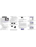
1.2 The Chart Display
The chartplotter includes a small-scale world map, detailed navigation
information is displayed when a chart card is installed.
The chartplotter screen includes a cursor data box which normally provides the
following information:
• The cursor position, in either latitude and longitude or TDs, depending on
your setup
• The vessel’s Course Over Ground (COG) and Speed Over Ground (SOG)
• A scale ruler in the selected units (e.g. nautical miles)
• The units in which chart depth data is displayed
• The cursor’s bearing (BRG) and range (RNG) from your vessel’s current
position
The cursor data box is also used to display the vessel’s position and the range
and bearing to the active waypoint, when the chartplotter is in Home Mode (see
Section 2.5).
A sample chart display, in its default configuration with a chart card installed, is
shown in the top illustration overleaf.
The chart display can show additional information, depending on the current
data and on your setup selections, as shown in the example display in the
bottom illustration overleaf. You can also display the cursor position from other
compatible displays (see Chapter 6).
Note: If required, you can use the setup options to change the units in which
information is displayed, turn off the cursor data box and soft key labels, and
change the chart orientation (see Chapter 6).
The
Chart Display
Summary of Contents for RayChart 630
Page 2: ...RayChart 620 and 630 Owner s Handbook Document number 81155_2 Date 11thMay1999...
Page 3: ......
Page 13: ...x RayChart620and630...
Page 23: ...10 RayChart620and630...
Page 41: ...28 RayChart620and630...
Page 53: ...40 RayChart620and630...
Page 61: ...48 RayChart620and630...
Page 97: ...84 RayChart620and630...
Page 115: ...102 RayChart620and630...
Page 117: ...104 RayChart620and630...
Page 121: ...108 RayChart620and630...
Page 127: ...114 RayChart620and630...