25
Localization (or Calibration, or Local Grid)
This operating mode is used in the following cases:
- The coordinate system should be unknown or its characteristics are not accurate
enough.
- The base station is operated on a reference point whose position only results
from a position determination in autonomous GPS mode.
- A local coordinate system is used for field operations.
In either of these 3 cases, you will have to calibrate your system before starting your
job, using control points. The use of 3 control points or more is highly recommend-
ed to achieve horizontal calibration. This number should be raised up to 4, or more,
to ensure vertical calibration, as this will guarantee the consistency of your control
points.
Click on the
Equip
tab and select
Localization
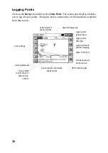
. The screen that now appears is de-
scribed below.
Control coordinates can be entered manually or read from a file stored in the hand-
held computer. When you click
ADD
to add a point, a new screen is displayed (see
figure 25 on next page). You may either enter the points coordinates manually or
select an existing point from the pre-defined list.
Edits the selected point
Deletes the selected point
Adds a new point to the list
Saves the current points list as
a *.dat file
Enables/disables the selecte
point for/from the calibation
process
Points list
Loads a points list from the
specified *.dat file
Provides access to Solution
Monitoring screen
Shows the geographic or plane coor-
dinates of the selected point
Summary of Contents for FAST Survey
Page 1: ...FAST Survey Getting Started Guide www thalesnavigation com THALES NAVIGATION...
Page 4: ...ii...
Page 35: ......

