


0019588_001
2.
While charging, the LED of the battery charger lights up orange.
When the battery is nearly charged, the LED turns yellow.
When the battery is fully charged, the LED turns green.
2.7
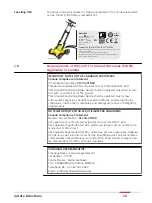
Requirements for Using a GNSS Antenna with the DSX
The DSX can be used with a GNSS antenna to position the radar-scanning data
in an absolute coordinates system and to receive real-time positional correc-
tions while the DSX cart is moving and collecting data.
The antenna should fulfill the following requirements:
•
Multi-frequency (L1 + L2 + L5)
•
Positioning update greater than 5 Hz
•
Bluetooth
•
RTK (Real-Time Kinematic) reference station functionality
•
RTK network
•
Unlimited RTK range
•
DGPS/RTCM
☞
Refer to the equipment list for compatible models.
For the best result achieved, we recommend using a GS18 T antenna with tilt
compensation.
Requirements
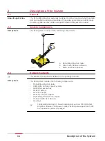
Description of the System
19


