


GLOSSARY
xlv
Sea state
Status of the sea condition due to the weather environment, expressed as a sea state 0 for flat
conditions with minimal wind, to sea state 8 for very rough sea conditions.
SET
The current direction for manual correction or the current speed on the horizontal axis of the 2-axis
log is displayed.
Sleeping AIS target
A target indicating the presence and orientation of a vessel equipped with AIS in a certain
location.
sm Statute
mile
1sm=1609.344m
SOG
Speed Over the Ground
The speed of the ship relative to the earth, measured on board of the ship.
SP Short
Pulse
STAB Stabilization
STC
Sensitivity Time Control
Function of STC reduces the impact of returns from sea state of relatively near from own ship.
STW Speed
Through
Water
The speed of the ship relative to the water surface.
T
TCPA
Time to Closest Point of Approach to own ship
Test target
Radar target of known characteristics used for test requirement.
TM True
Motion
A display across which own ship moves with its own true motion.
Trails
Display Radar Trails (Other Ships' Trails).
True course
The direction of motion relative to ground or to sea, of a target expressed as an angular
displacement from north.
True speed
The speed of a target relative to ground, or to sea.
True vector
A vector representing the predicted true motion of a target, showing course and speed with
reference to the ground or sea.
TT Target
Tracking
A computer process of observing the sequential changes in the position of a radar target in order
to establish its motion. Such a target is a Tracked Target.
TTG Time
To
Go
Time to next waypoint.
TXRX Transceiver
Unit
U
USB
Universal Serial Bus
USB was designed to standardize the connection of computer peripherals.
UTC
Universal Time Coordinated
The international standard of time, kept by atomic clocks around the world.
V
VRM Variable
Range
Marker
An adjustable range ring used to measure the distance to a target.
W
Waypoint
A geographical location on a route indicating an event.
Summary of Contents for JMA-3400 Series
Page 2: ......
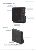
Page 23: ...WARNING LABEL MOUNTING POINT xxi NKE 2103 4 4HS 6 6HS SCANNER UNIT NCD 2364 DISPLAY UNIT ...
Page 31: ...EQUIPMENT APPEARANCE xxix NKE 2043 SCANNER UNIT NKE 2063A AHS SCANNER UNIT ...
Page 32: ...EQUIPMENT APPEARANCE xxx NKE 2103 4 4HS 6 6HS SCANNER UNIT ...
Page 34: ...EQUIPMENT APPEARANCE xxxii Fuse ...
Page 48: ......
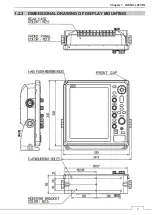
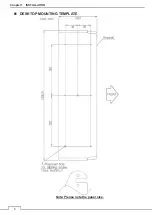
Page 51: ...Chapter 1 INSTALLATION 3 1 2 3 DIMENSIONAL DRAWING OF DISPLAY MOUNTING ...
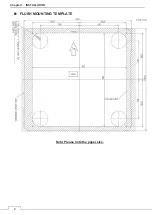
Page 56: ...Chapter 1 INSTALLATION 8 FLUSH MOUNTING TEMPLATE Note Please note the paper size ...
Page 85: ...Chapter 2 THE BASIC OPERATION 37 2 2 OPERATION UNIT ࢫࣆ ձ ղ ճ մ յ ն շ ո չ պ վ տ ւ ջ ռ ս ր ց ...
Page 266: ...Chapter 13 SPECIFICATIONS 218 13 1 SCANNER DIMENSION 13 1 1 NKE 2043 ...
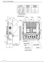
Page 270: ...Chapter 13 SPECIFICATIONS 222 13 2 DISPLAY DIMENSION 13 2 1 NCD 2364 ...
Page 283: ...235 Chapter 13 SPECIFICATIONS MEMO ...
Page 293: ...APPENDIX A 10 MEMO ...
Page 313: ......