background image

Customer Helpline: 0870 873 0080

33

Detailed Route Planning

Map Options

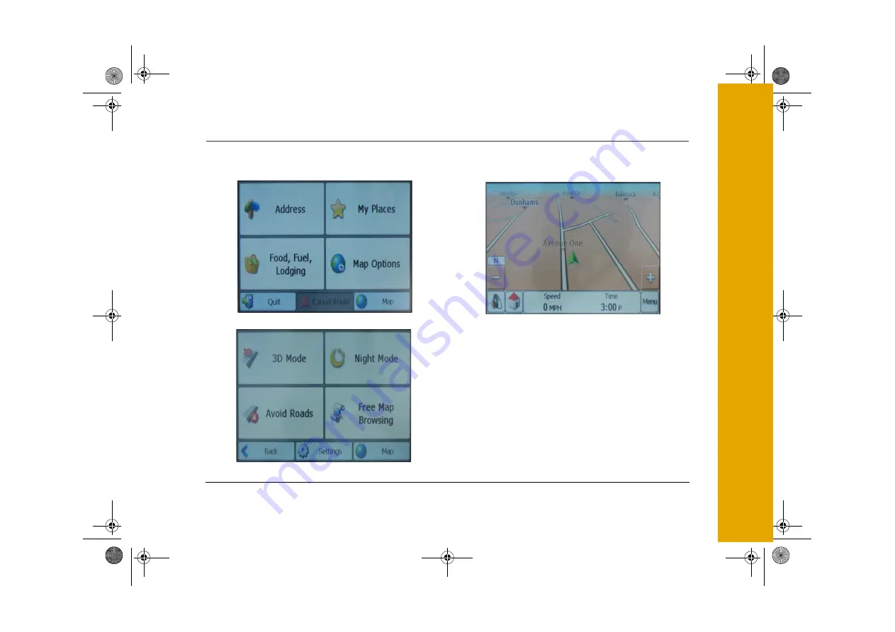
The Map Options menu contains the following options:

2D/3D Mode

Tap the 2D/3D Mode icon to change the display 
between a 2D and a 3D display. The 2D map is 
optmized for daytime viewing and will allow you to 
use the pan and zoom functions.

GNAV22.book  Page 33  Friday, September 22, 2006  11:53 AM

Summary of Contents for GNAV22

Page 1: ...GNAV22 book Page 1 Friday September 22 2006 11 53 AM ...

Page 2: ...Using the Stylus 11 Settings 11 Daylight Saving Time 12 GPS Receiver 12 External Antenna 13 Sidewheel 13 Earphones 13 Switching Off 13 Planning Your First Journey 14 Initial Setup 14 Navigate to an Address 15 Navigate to a Map Location 17 The Navigation Map 18 Menu Icons 20 Map Symbols 20 Journey Completion 20 Detailed Route Planning 21 The Navigation Menu 21 Address 21 Address Modes 22 Address Ac...

Page 3: ...9 Route 39 Map Settings 39 Quick Nav 40 Select Map 41 Start Demo 42 Tutorial 42 About 42 Help 42 Destinator Console 43 PC Requirements 43 Installing the Console 43 Console Toolbar 44 Console Menus 44 Maps 45 Import Favorite Location 46 Map Screen Interface 47 Installing a Map 47 Load Map 48 Remove Map 48 MP3 Player 49 Care and Maintenance 51 Troubleshooting 51 Guarantee 53 GNAV22 book Page 3 Frida...

Page 4: ...ns to operate the system The Global Positioning System The Global Positioning System GPS is a satellite based system that provides location and timing information around the globe GPS is operated and controlled under the sole responsibility of the Government of the United States of America who are responsible for its availability and accuracy Any changes in GPS availability and accuracy or in envi...

Page 5: ...ve environments Do not operate or store your Satellite Navigation System in high temperatures 60o C or in direct sun light Do not store in a microwave or pressurised container Do not pierce or break the battery casing Failure to follow these cautions may cause the battery to leak acid become hot explode or ignite and cause injury or damage If you come into contact with leaked battery acid wash tho...

Page 6: ... experience any problems please check the Troubleshooting guide at the back of this user guide before contacting the customer helpline In the Box In the box you will find Satellite Navigation System Protective Sleeve Mains Power Adapter DC power lead with 12V car adapter Cradle and Car Mount User Guide Disk with extra maps Earphones GNAV22 book Page 6 Friday September 22 2006 11 53 AM ...

Page 7: ...set button 2 MP3 button 10 Charging indicator 3 Map button 11 GPS Antenna 4 Menu button 12 Touch Screen 5 Zoom in out button 13 Stylus 6 Speaker 14 Adjustment button 7 DC In socket 15 Headphone socket 8 SD Card slot used by the MP3 player GNAV22 book Page 7 Friday September 22 2006 11 53 AM ...

Page 8: ...mode recharge by connecting either the mains adapter or the 12V car accessory adapter when the battery is low We recommend that when you use the Satellite Navigation System in your car that you always use the 12V car accessory adapter in order to maintain the battery level If the battery level is low the GPS reception will be reduced In order to optimize signal reception keep the battery charged R...

Page 9: ...three lugs one at the top and two at the bottom These fit into slots on the Satellite Navigation System Slide the bottom lugs into the Satellite Navigation System then click the top lug into the slot To remove the Satellite Navigation System from the cradle push the tab above the top lug Pull the Satellite Navigation System forward of the top lug and then up to release it from the bottom lugs GNAV...

Page 10: ...and push the lever towards the pad until it clicks into place 3 Position the adjustable arm to suit Switching On Note To reduce the chance of the Satellite Navigation System freezing ensure that the ignition is switched on before the Satellite Navigation System is switched on Press and hold down the Power On Off button until the Goodmans logo is displayed The lights behind the buttons will glow Th...

Page 11: ...to press the stylus hard on the screen Settings Note You do not need to enter the Settings menu before you start to navigate Tap the stylus on the Settings icon The following screen will be displayed Tap the Back icon at any time to go back to a previous screen Note It is possible to enter the Settings menu at any time by pressing the Menu button to the right side of the display Back Icon GNAV22 b...

Page 12: ... Greenwich Mean Time The Time Settings screen contains the option to advance the clock by one hour during daylight saving months British Summer Time Tap the Set Daylight Saving icon to advance the clock GPS Receiver Note At least three GPS signals are required for the Satellite Navigation System to operate Note If the Satellite Navigation System is being used for the first time up to 10 minutes ma...

Page 13: ...tenna into the socket on the left side of the GPS antenna You should now receive a valid signal Sidewheel The sidewheel is used to adjust the message volume or the display brightness of the Satellite Navigation System Move the sidewheel to open the control box Move the sidewheel up to increase or down to decrease the volume If necessary tap the Mute icon with the stylus to turn off sound Use the s...

Page 14: ...our Satellite Navigation System navigation system is supplied with the following default settings To find the quickest route To travel by car Allows all types of roads including toll roads tunnels and ferries The distances will be in miles The audio and visual language is English Making changes to these settings is described in a later section Switch the Satellite Navigation System on and tap the ...

Page 15: ...sh to go to tap the Address icon Read the information message and tap OK Tap the keypad to enter the destination city The Satellite Navigation System will automatically search for the closest city for each letter entered To search through an alphabetical list of cities use the up and down arrows at the top right of the keypad Tap Enter GNAV22 book Page 15 Friday September 22 2006 11 53 AM ...

Page 16: ...he destination If the destination displayed is correct tap Go The Satellite Navigation System may take a few seconds to display the route The map displayed will show a green flag indicating the start point of the journey The display will show the direction you need to travel and you will be given verbal prompts The details of the map are given on page 18 GNAV22 book Page 16 Friday September 22 200...

Page 17: ...your last known destination will be displayed You can move the map by placing the stylus on the screen and dragging across Using these operations locate your destination on the map When the destination is found tap the display at the exact location Tap the Go There icon in the box that appears The box also includes options to add to favorites and set as origin Add to favorites includes the address...

Page 18: ...ent street Tap the Volume icon to turn on or turn off sound A red cross over the icon will indicate the volume is turned off Tap the Menu icon to return to the Navigation menu Tap the QuickNav icon to display the route to the specified QuickNav location see page 40 The top directions bar gives information about the selected route The bearing for each section of the route is displayed at the left o...

Page 19: ... Tap the Route icon to display an overview map of the route The overview map shows the entire route and gives distance and time information Specific roads can be excluded from the Satellite Navigation System route calculation Highlight a specific road and tap the avoid icon The Satellite Navigation System will then recalculate the route without the selected road see page 34 GNAV22 book Page 19 Fri...

Page 20: ...e the Satellite Navigation System The Help icon displays technical support information The Done icon confirms the displayed settings Map Symbols Journey Completion The Satellite Navigation System will announce journey completion when you reach your destination Tap the Menu icon to return to the Navigation menu Your current location Your last known destination where the GPS signal was reliable The ...

Page 21: ...the automatic search feature does not find your specific address use the find icon to do a sub search This is particularly useful when the name consists of two or more words The Scroll icons let you move up or down the list of address items The Hide Display Keyboard icon lets you extend or shorten the address list by hiding or displaying the keyboard The select key icon lets you display numeric ch...

Page 22: ...street is selected the first entry within the address number list is a street midpoint 2 Street City Street City displays the following address screens Street City and Address Number This search is useful where an address is being searched for in an area where there are many cities and towns 3 Cross Streets This search displays the following address screens City Street 1 and Street 2 This search i...

Page 23: ... be set as the route origin This is useful when calculating a route that starts at a different point than the current location 2 Show on Map Displays the selected address on the map 3 Add to My Favorites This will include the selected address in a list of favorite locations see page 24 My Places The My Places menu contains information about favorite locations stored and also previous locations vis...

Page 24: ...f location groups All the favorite locations are organised into these groups Note The My Favorites folder is the default folder where all favorites are stored if not assigned to a group To open a group highlight a group with the stylus and tap Enter or tap twice with the stylus A list of favorite locations will be displayed Highlight a location and tap Enter to view the favorite location on the ma...

Page 25: ...avorites Group screen is displayed tap the Actions icon to display the following options 1 The Add Group option opens up the keyboard Enter the name of the group and tap Save The new group will appear on the Favorite groups screen 2 To edit a group highlight the group and tap the Edit icon The keyboard opens with the existing group name highlighted The name of the group can now be changed Tap Save...

Page 26: ... the route origin 2 Show on Map Displays the selected address on the map 3 Edit Favorite Location This option opens up the keyboard with the existing location name highlighted The name of the location can now be changed The location can also be moved to a different favorites group by tapping the left and right arrows 4 Del Favorite Location This option is used to remove a location from the list A ...

Page 27: ...istances are 110 yards 550 yards 0 6 miles and 1 2 miles 2 If the Satellite Navigation System displays in Kilo metres the available alert distances are 100 metres 500 metres 1 kilometre and 2 kilometres Note Alert can be set for a group but not for an individual location Alerts can be disabled for all groups by setting the first Alert to Off Alerts can be disabled for an individual group by tappin...

Page 28: ...n highlighted tap the Actions icon to show the following screen 1 Set as Origin This option allows the selected location to be set as the route origin This is useful when calculating a route that starts at a different point than the current location 2 Add to My Favorites This option will include the selected location in the list of favorite locations see page 24 GNAV22 book Page 28 Friday Septembe...

Page 29: ...move all locations from the History list A warning message is displayed before deletion Tap Yes to confirm deletion Food Fuel and Lodging The Food Fuel and Lodging menu contains information about useful and interesting locations to visit The locations are organised into numerous categories Tap the Food Fuel and Lodging icon to enter the category list Tap More to view another screen of categories G...

Page 30: ...ring text in the POI Category box Tap Enter to accept the highlighted category If the initial search returned no category results tap the Find icon to do a sub search The Find icon is at the top right of the screen This is particularly useful when the category name consists of two or more words When a category has been selected the Satellite Navigation System automatically displays the closest res...

Page 31: ... is known about the area 3 Other Address This option searches for a category near a specified location When this option is tapped the keyboard opens and a location can be specified 4 Search Radius This option is used to specify the category distance from the specified location The distance options available are dependent on the Unit of Measure set with the Map Options see page 38 If the Satellite ...

Page 32: ...cation within Categories has been selected the Actions icon can be tapped to access the following options 1 Set as origin This option allows the selected location to be set as the route origin This is useful when calculating a route that starts at a different point than the current location 2 Show on Map Displays the selected location on the map 3 Add to My Favorites This will include the selected...

Page 33: ...Options menu contains the following options 2D 3D Mode Tap the 2D 3D Mode icon to change the display between a 2D and a 3D display The 2D map is optmized for daytime viewing and will allow you to use the pan and zoom functions GNAV22 book Page 33 Friday September 22 2006 11 53 AM ...

Page 34: ...r conditions Avoid Roads Tap the Avoid Roads icon to specify certain roads to be permanently excluded from your route calculations Use this feature when you want to avoid congested roads unsafe roads or toll roads The Avoid Roads screen displays the Toll Roads and Avoid Roads groups Tap the Actions icon to add edit or delete avoid road groups GNAV22 book Page 34 Friday September 22 2006 11 53 AM ...

Page 35: ...o keep the changes 3 Delete Group Highlight the group and tap the Delete icon The highlighted group will be deleted The Toll Roads and My Roads to Avoid groups cannot be edited or deleted When a group has been highlighted tap the Allow Avoid icon to include or exclude all the roads within that group from route calculations To open a group highlight a group with the stylus and tap Enter or tap twic...

Page 36: ...with the existing road name highlighted The name of the road can now be changed The road can also be moved to a different group by tapping the left and right arrows 3 Delete Item Highlight a road within the group and tap Delete Item This option will remove the highlighted road from the group 4 Show on Map Displays the selected road on the map When a road has been highlighted tap the Allow Avoid ic...

Page 37: ...splay at the exact location The box that appears gives the options to Go There Add to My Favorites or Set as Origin A target symbol indicates the current set origin To navigate to a destination found on the free map go to map options and switch GPS back on The Map Options menu also contains the Settings icon Settings The Settings menu contains the following options Tap Prompts to select the type o...

Page 38: ... signal is too low and unreliable for navigation 4 Drive Carefully This is a friendly reminder at the start of each journey 5 Symbols Directional prompts are displayed in diagram form such as an arrow 6 Text Directional prompts are displayed in written form 7 None No directional prompts are displayed Units of Measure Tap the Units of Measure icon to select the units of measure used in all Satellit...

Page 39: ...n to change the way the Satellite Navigation System calculates the route 1 Quickest route Quickest route is the default setting and selects the route that takes the least time 2 Shortest route Shortest route selects the route that is the least distance Map Settings Tap the map settings icon to customize the map display The following options are available 1 Forward is up This option orients the map...

Page 40: ...ck Nav icon to define the Quick Nav locations When a Quick Nav location is selected you can navigate to that location at any point by tapping the Quick Nav icon at the bottom of the map The following options are available 1 To Predefined Address Tap Set Address to enter the city street and address number for the Quick Nav location 2 To Nearest POI Category Tap To Nearest POI Category to select a c...

Page 41: ...d map used by the Satellite Navigation System Map details and version numbers are given Tap the up and down arrows to highlight a different map The following options are available 1 Refresh This option refreshes the screen when a new memory card is inserted into the device GNAV22 book Page 41 Friday September 22 2006 11 53 AM ...

Page 42: ... simulated route Many of the Satellite Navigation System navigational features are disabled when the demo is running Tap the Quit Demo icon to end the demo Tutorial Tap the Tutorial icon to start the Satellite Navigation System guided tour Use the left and right arrows to scroll through the tutorial display screens End the tutorial by tapping the Red Cross icon About Tap the About icon to display ...

Page 43: ... The Satellite Navigation System Console Installation Wizard prompts you to select the language used for the installation process When you have selected a language click OK 2 Please read the Welcome message and click Next 3 From the Select Directory screen either accept the recommended default directory or browse to a different directory to install the Satellite Navigation System Console Click Nex...

Page 44: ... your PC to the selected My Favorites group on your device Console Menus The console menus are described below File This menu lets you select from the following options Install Software Same as the Install Software toolbar button This menu option lets you install the Satellite Navigation System software to your device Install and Remove Maps Same as the Install and Remove Maps toolbar button Lets ...

Page 45: ...orites Importer The same as the Favorites Importer toolbar button Select a csv file containing Favorites information to import from the PC to your device For more information see Import Favorite Location on page 46 Languages You can select a language that is displayed in the Satellite Navigation System Console Help This menu lets you select from the following options User manual Displays the User ...

Page 46: ...orites Importing file structure must be in csv format Note The Longitude and Latitude are numerical values All the others are string values To import a csv file 1 On the Satellite Navigation System Console click on a standard map This enables the Installing Map and Favorites Importer features 2 Click the Favorites Importer button The Converter dialogue box is displayed 3 Select the csv file specif...

Page 47: ...dy loaded on your device Installing a Map You can install a map by selecting it from the Standard Maps screen in the Satellite Navigation System Console and clicking the Install Remove Maps button The Target Device dialogue box appears Select either Storage Card on a mobile device or Main Memory on a PC The amount of memory available for the selected target device appears on the Target Device Memo...

Page 48: ... have selected your target device and have confirmed that there s sufficient memory click the Install Remove Maps button Your selected maps are installed and appear in the Installed Maps screen Remove Map In the Target Device screen click the Change button and select the location from where to remove the map You can choose from Main Memory Storage Card or Removable Disk This updates the Installed ...

Page 49: ...layed Tap the up and down arrows to scroll through the list of songs and albums Home Repeat Up Play Close Tap the Home icon to return the display to the Main menu screen Tap the Repeat icon once to repeat the highlighted track Tap the Repeat icon again to repeat all the tracks in the library Tap the Repeat icon again to turn off Tap the Up icon to navigate up from the current folder Tap the Play i...

Page 50: ...ons to move through the currently playing track Tap the Play icon to begin playback of the selected track Tap the Stop icon to stop current playback Tap the Repeat icon once to repeat the current track Tap the Repeat icon again to repeat all the tracks due for playback Tap the Up icon to close the player window Up Repeat Stop Forward Back Play GNAV22 book Page 50 Friday September 22 2006 11 53 AM ...

Page 51: ...ocation on the map Try using the free map function to find the location instead The Satellite Navigation System cannot find a GPS signal Note Satellite signals are required for the Satellite Navigation System to function properly There may be occasions within your home or building when the signal strength is limited and navigation may not be possible This is quite normal for products of this type ...

Page 52: ...em does not use the most obvious route This may be because there has been a new road opened that is not in the map s memory If when tracking the obvious route it looks like you are travelling across country then the road is not in the maps memory The Satellite Navigation System is on but will not respond to commands The software can sometimes take a few seconds to respond Try resetting the Satelli...

Page 53: ...ry of purchase The product must be correctly assembled and operated in accordance with the instructions contained in this booklet The guarantee does not cover accidental damage misuse or consumable items The guarantee will be rendered invalid if the product is resold or has been damaged by inexpert repair The manufacturer disclaims any liability for incidental or consequential damages This guarant...

Page 54: ...GNAV22_Rev2_SEP06 GNAV22 book Page 57 Friday September 22 2006 11 53 AM ...

Reviews: