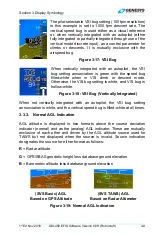


Section 3 Display Symbology
1
st
Ed Nov 2018
IDU-450 EFIS Software Version 8.0H (Rotorcraft)
3-19
NOTE:
There is a one-degree dead band to prevent grid flicker while flying along
one of the boundary latitudes. The grid space switching changes at one
degree less latitude when flying towards the Equator than it does when
flying toward the Poles.
At latitudes greater than 75°, no grid lines are shown. To keep the grid
spacing relatively consistent, at latitudes between 45° and 75°, the
longitude spacing is increased according as follows.
Table 3-8: LAT-LON Resolution Boundaries
Latitude Range
Longitude Grid
Spacing
Heading Boundary
Pole Equator
0° to 46°
24 arc-seconds
46° to 62°
48 arc-seconds
46°
45°
62° to 70°
72 arc-seconds
62°
61°
70° to 74°
96 arc-seconds
70°
69°
74° to 75°
120 arc-seconds
74°
73°
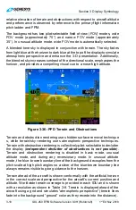
Table 3-9: Terrain and Obstruction Rendering Levels
Feature Coloring
Notes
SVS
BASIC
Shades of brown for
non-water terrain.
Amber and red colors not used
for normal display of terrain.
Deep blue denotes areas of
water and takes precedence over
the shades of brown.
SVS
TAWS
Shades of olive when at
or below 100 ft. below
aircraft altitude.
Shades of brown when
above 100 feet than
aircraft altitude.
TAWS coloring of FLTA
alert or warning cells.
Amber and red colors used for
normal display of terrain and to
show terrain areas causing FLTA
alerts.
Deep blue denotes areas of
water and takes precedence over
other colors.
None
No terrain nor obstructions are shown. Neither,
SVS BASIC
or
SVS TAWS
is selected.