


·
FIS - Flight Information Service (WSI InFlight) (See
page 71)
·
LT - Lightning Strikes (See page 81)
·
CHART - Chart View (See page 86)
·
RADAR - Weather Radar (See page 100)
·
SYS - System Information (See page 105)
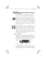
The Message Log displays information from the MX20 or
reported to the MX20 by its external sensors. A flashing
MSG annunciator notifies you of a new message that
should be viewed. The Custom Map function allows you
to completely customize the displayed map by overlaying
selected information. The Custom Map can become
“cluttered” if you choose every option, so use discretion.
The IFR Chart function provides an IFR en route style
map on the display. The VFR Chart function provides a
VFR sectional style map for the display. The Split Screen
function allows up to two of the other functions to be
displayed side by side and an optional vertical profile
across the bottom of the display. The Traffic function
(when installed) shows nearby traffic and details about
each target. The Flight Plan function provides details
about your flight plan and each waypoint. The Terrain
function shows a color coded map of terrain elevation in
relation to your altitude. The Flight Information Services
function, when installed, is capable of displaying text and
graphic
weather
information
with
UAT-
and
WSI-equipped installations. The Lightning function,
when connected to the Goodrich WX500 Stormscope,
controls the overlay of lightning strike information on the
map displays. The Chart View feature provides the
capability to view Jeppesen Sanderson Inc. electronic
charts. Two basic types of charts can be viewed: Approach
charts and airport surface charts. The Radar Function
allows weather radar from the ART2000, ART2100, or
RS-181A to be displayed. The System Information
function lets you set general preferences, show software
version information, and test the display.
2
Getting Started


